Where can I fly my drone in the UK and get £5,000,000 Public Liability Insurance cover? Welcome to Drone Scene!

Wondering where you can legally fly your drone? Looking for great places to fly? Looking for £5m Public Liability Insurance cover? Well look no further!

Welcome to Drone Scene, the place to find great drone flying locations in the UK, view images and videos posted by other pilots and share your flying locations in order to help other UK hobbyists find great locations where they can fly safely too.

Click on a marker pin to view details of that location. You can also add comments and discuss the location in our forum.

×You must login to see Airspace Restrictions, National Trust boundaries and other interactive map layers.

Highclere Castle added to Castles and Fortifications in South East by clinkadink on 01/01/2022

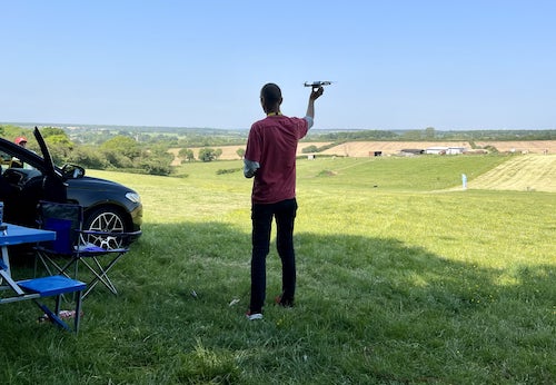
TOAL was from Beacon Hill, outside the Highclere Estate.

The first written records of the estate date back to 749 when an Anglo-Saxon King granted the estate to the Bishops of Winchester. Bishop William of Wykeham built a beautiful medieval palace and gardens on the park.

Later on, the palace was rebuilt as Highclere Place House in 1679 when it was purchased by Sir Robert Sawyer, Attorney General to Charles II and James II and direct grandfather of the current Earl.

In 1771, ‘Capability’ Brown made plans for the alteration of the grounds, water and symmetrical Georgian house at Highclere for the 1st Earl of Carnarvon.

In 1842, Sir Charles Barry – who was also working on the Houses of Parliament at the time – finished his final designs for the 3rd Earl of Carnarvon, transforming Highclere Place House into Highclere Castle.

The Countess’ research has revealed that, in 1867, the Constitution of Canada was drawn up in the British North America Act by 4th Earl of Carnarvon and John A. Macdonald, later the first Prime Minister of Canada.

The history of planes begins at Highclere Castle in 1910, with Sir Geoffrey De Havilland making his first flight on the Highclere Estate at Seven Barrows.

In 1922, the 5th Earl of Carnarvon discovered Tutankhamen’s Tomb with trusted colleague and friend Howard Carter.

During the First World War, Highclere Castle was converted into a hospital for wounded soldiers run by the 5th Countess of Carnarvon.

https://en.wikipedia.org/wiki/Highclere_Castle

Land owner permission requirements unknown.

View and discuss this location in more detail on Grey Arrows.

Co-ordinates: 51.32653, -1.360713 • what3words: ///saga.hillsides.giggled

The originator declared that this location was not inside a Flight Restriction Zone at the time of being flown on 01/01/2022. It remains the responsibility of any pilot to check for any changes before flying at the same location.

Where to fly your drone


Recently added locations

Rhosydd Quarry (By Dren)

Rather wet, muddy walk upto Rhosydd quarry from the Llyn Cwmorthin lake below. Carpark is situated just outside Tanygrisiau, steep narrow roads upto carpark. Gives you an idea of the paths elevation upto plateau. You can fly anywhere here there are no restrictions in the area. Old slate buildings and ruins everywhere

Land owner permission not required.

View and discuss this location on Grey Arrows.

Co-ordinates: 53.00009, -3.978918 • what3words: ///womanly.holly.momentous

Rottingdean (Undercliff Walk) (By Markm0)

You can park in the Marine Cliffs pay and display carpark.

Land owner permission requirements unknown.

View and discuss this location on Grey Arrows.

Co-ordinates: 50.80204, -0.055248 • what3words: ///butter.spud.takeover

Kelsey Park Beckenham (By grandad1950)

A local nature reserve with lots of water fowl and birds to enjoy. Well manicured gardens, Ideal for a relaxing short break

Land owner permission requirements unknown.

View and discuss this location on Grey Arrows.

Co-ordinates: 51.40097, -0.021998 • what3words: ///dome.clips.jazzy

Portmeirion (By Dren)

Parked in carpark, walking through village and beyond lighthouse towards beach, follow gravel path to steps leading down to Sandy beach. Able to TOAL from estuary whilst tide was out. Quick flight upto village keeping my distance due to weight of drone.
Drone scene check before flight showed no warnings

Land owner permission requirements unknown.

View and discuss this location on Grey Arrows.

Co-ordinates: 52.90978, -4.101055 • what3words: ///young.carefully.massaging

Inverness Locks (By Bfarrell)

Another wee fly about at night getting used to the drone.

Nice calm night

Land owner permission not required.

View and discuss this location on Grey Arrows.

Co-ordinates: 57.48257, -4.247438 • what3words: ///universally.daring.locals

Aldourie Castle (By Bfarrell)

Took off from loch end.
A quick scoot down to the Castle. Just breaking in the new drone so I'll be back there for sure.

Land owner permission not required.

View and discuss this location on Grey Arrows.

Co-ordinates: 57.40802, -4.329088 • what3words: ///signal.couriers.steer

Cargill's Leap (By AlbionDrones)

The location of a 17thC Covenanter's escape from the redcoats, a rocky rapids in the River Ericht near Blairgowrie in Perthshire.

Park at the car park and then walk down the steps, and fly from the bridge - currently closed due to storm damage - or cross and walk further along the opposite bank.

Beware the trees and the double cable crossing the river upstream from the passenger footbridge.

Land owner permission not required.

View and discuss this location on Grey Arrows.

Co-ordinates: 56.59906, -3.340641 • what3words: ///renting.ranch.loom

Ballymorran Bay (By TristantheDog)

Great area to view a portion of Strangford Lough with its drowned drumlins created during the last ice age. Toal any where along the waters edge. Note area used by kayaker’s. Also when tide is out usually the are a fair number of wading bird. Also along the road on the land ward side are telephone lines. Other wise great spot.

Land owner permission not required.

View and discuss this location on Grey Arrows.

Co-ordinates: 54.46638, -5.655255 • what3words: ///choice.betraying.rewarding

Malmesbury Abbey (By jason5223)

My TOAL point was the Public pay and display car park 200 metres north of the abbey.
Be aware that the abbey sits about 120 feet above the car park level so be mindful of the height of your drone at this location

Land owner permission requirements unknown.

View and discuss this location on Grey Arrows.

Co-ordinates: 51.58458, -2.098292 • what3words: ///lectured.lawfully.rift

Marlborough High Street Wiltshire (By jason5223)

High Street in the historic town of Marlborough Wiltshire.
Parking on the high street and a very short walk to the churchyard behind the Town Hall.

The Churchyard has a wide open space to TOAL from

Land owner permission not required.

View and discuss this location on Grey Arrows.

Co-ordinates: 51.42143, -1.729977 • what3words: ///hubcaps.drumbeat.noon


Show All Locations

Service provided by