|
 TOAL from M67Q+2V, Tintagel PL34 0DL TOAL from M67Q+2V, Tintagel PL34 0DL
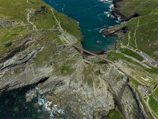
Tintagel Castle is a legendary and dramatic site on the North Cornwall coast, steeped in history and myth, famously associated with King Arthur. It's set on a rugged, windswept peninsula, with ruins spread across the mainland and an island, connected by a striking modern bridge. The landscape features dramatic cliffs, a beautiful cove (Merlin's Cave), and crashing waves.
It's an excellent place to fly a drone for several reasons:
Dramatic Scenery: The combination of ancient ruins, rugged cliffs, the iconic bridge, and the turbulent sea offers incredibly dramatic and visually rich footage.
Unique Perspectives: A drone allows you to capture angles and perspectives that are impossible from the ground, showcasing the scale of the castle and its stunning natural setting. You can highlight the bridge, the isolation of the island, and the vastness of the coastline.
Historical Context: The aerial views can emphasize the strategic, defensive nature of the castle's location and its integration with the natural landscape.
Accessibility to Features: You can get close-up shots of cliff faces, the cove, and the various parts of the castle ruins without physical access limitations.
Important Note for Drone Pilots: When flying near Tintagel Castle, it's crucial to be aware of and respect any local drone regulations, National Trust guidelines (as it's a National Trust site), and general drone safety rules, especially concerning proximity to people, wildlife, and historical structures. Always check for any flight restrictions before flying.
View and discuss this location on Grey Arrows.
Co-ordinates: 50.66867, -4.761829 • what3words: ///schools.bins.patch
|