Where can I fly my drone in the UK and get £5,000,000 Public Liability Insurance cover? Welcome to Drone Scene!

Wondering where you can legally fly your drone? Looking for great places to fly? Looking for £5m Public Liability Insurance cover? Well look no further!

Welcome to Drone Scene, the place to find great drone flying locations in the UK, view images and videos posted by other pilots and share your flying locations in order to help other UK hobbyists find great locations where they can fly safely too.

Click on a marker pin to view details of that location. You can also add comments and discuss the location in our forum.

×You must login to see Airspace Restrictions, National Trust boundaries and other interactive map layers.

Belas Knap added to Iconic Landscapes and Ancient Sites in South West by clinkadink on 22/01/2023

Parking: 51.927883, -1.967025
TOAL: 51.927737, -1.970824

I parked on the on the road 300m to the east of Belas Knap, as instructed by Google Maps. What it didn't mention is that I had to travel on foot through a dense, frozen forest and up a 200m hill. Afterwards, I found out there is a dedicated car park for Belas Knap 750m to the north.

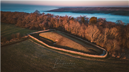
Belas Knap is a Neolithic long barrow or burial mound (about 2 miles south of Winchcombe), and which was built more than 5,500 years ago.

As is sometimes found at ancient burial sites, Belas Knap features a large false entrance and two hidden side-entrances that actually lead into the burial chambers. This may have been to deter grave-robbers or to serve as a ‘spirit door’, through which the souls of the deceased may walk and receive the offerings left by their descendants during ceremonies.

At some point in Belas Knap’s lifetime however, its side doors were blocked up preventing its further use as a burial site. They were reopened however when site was excavated between 1863 and 1865, with the remains of 31 people found inside. Four different burial chambers were unearthed, as well as a collection of skeletons from children and one young adult beneath the false entrance. A circle of flat stones was also discovered in the centre of the mound, along with animal bones and flint artefacts.

The people buried here likely lived a life of hunting, cattle-herding and small scale farming, while two skeletons who died from severe head wounds suggest raiding and conflict may have been common in the period.

The barrow is about 178 feet (54 m) long, about 60 feet (18 m) wide and nearly 14 feet (4.3 m) in height.

Today Belas Knap Long Barrow is managed by English Heritage and has been restored to its original condition, presenting a fascinating look into ancient life in Britain. Once a clearly significant burial site, it is 54 m long, 18 m wide and over 4m high, with the false entrance and side chambers still visible today.

The atmospheric chamber tombs inside the mound now remain open, allowing visitors to enter inside and see them up close. To get a further idea of the site’s significance, information boards give its intriguing history as well as a diagram of the various chambers inside.


https://www.winchcombemuseum.org.uk/belas-knap

Land owner permission not required.

View and discuss this location in more detail on Grey Arrows.

Co-ordinates: 51.92743, -1.970963 • what3words: ///innocence.porridge.handicaps

The originator declared that this location was not inside a Flight Restriction Zone at the time of being flown on 21/01/2023. It remains the responsibility of any pilot to check for any changes before flying at the same location.

Where to fly your drone


Recently added locations

Tilehurst Water Tower (By apreading)

Erected in 1932, Tilehurst Water Tower, is an iconic landmark on the ridge line in Tilehurst, a district in the Western part of Reading. People from Reading know they are near home when they are coming along the M4 from the West and they can see the top of the tower, several miles before they get to Junction 12.

In November 2018 the tower was illuminated in poppy red to mark 100 years since the end of the First World War. The tower remained illuminated, and visible at night from a wide area, until Remembrance Day on 11 November.

It still fulfils its function as a water tower today, and at the top it also houses a number of telephone masts and receivers and also the transmitter for Greatest Hits Radio Berkshire & North Hampshire, a local radio station.

The tower holds a huge 900,000 litres of water, in two 4.5 metre deep tanks and provides around 10 per cent all the water used in Reading, serving 12,000 homes and businesses.

Land owner permission not required.

View and discuss this location on Grey Arrows.

Co-ordinates: 51.45163, -1.047077 • what3words: ///knee.pose.sand

Deangate Ridge Country Park (By RestlessZombi)

This has been the site of many Drone Meetups. Camera Drones, FPV Drones and Fixed Wings have been flown around this area without issue.

Often used by Dog Walkers.

Security Guard is happy with Drones being flown and likes biscuits.

Park in the Car Park for free and walk to site.

Land owner permission not required.

View and discuss this location on Grey Arrows.

Co-ordinates: 51.43191, 0.547509 • what3words: ///skillet.example.forgiven

Scar House Reservoir (By Sleepwalker)

Its a free carpark only about 5 mins away from the first dam if you stick to the left its foot path to the seconed dam but if you dont mind hiking and have appropriate footware then you can do a full circle around the reservoir

Land owner permission requirements unknown.

View and discuss this location on Grey Arrows.

Co-ordinates: 54.1877, -1.907498 • what3words: ///wreck.multiply.recipient

Rhosydd Quarry (By Dren)

Rather wet, muddy walk upto Rhosydd quarry from the Llyn Cwmorthin lake below. Carpark is situated just outside Tanygrisiau, steep narrow roads upto carpark. Gives you an idea of the paths elevation upto plateau. You can fly anywhere here there are no restrictions in the area. Old slate buildings and ruins everywhere

Land owner permission not required.

View and discuss this location on Grey Arrows.

Co-ordinates: 53.00009, -3.978918 • what3words: ///womanly.holly.momentous

Rottingdean (Undercliff Walk) (By Markm0)

You can park in the Marine Cliffs pay and display carpark.

Land owner permission requirements unknown.

View and discuss this location on Grey Arrows.

Co-ordinates: 50.80204, -0.055248 • what3words: ///butter.spud.takeover

Kelsey Park Beckenham (By grandad1950)

A local nature reserve with lots of water fowl and birds to enjoy. Well manicured gardens, Ideal for a relaxing short break

Land owner permission requirements unknown.

View and discuss this location on Grey Arrows.

Co-ordinates: 51.40097, -0.021998 • what3words: ///dome.clips.jazzy

Portmeirion (By Dren)

Parked in carpark, walking through village and beyond lighthouse towards beach, follow gravel path to steps leading down to Sandy beach. Able to TOAL from estuary whilst tide was out. Quick flight upto village keeping my distance due to weight of drone.
Drone scene check before flight showed no warnings

Land owner permission requirements unknown.

View and discuss this location on Grey Arrows.

Co-ordinates: 52.90978, -4.101055 • what3words: ///young.carefully.massaging

Inverness Locks (By Bfarrell)

Another wee fly about at night getting used to the drone.

Nice calm night

Land owner permission not required.

View and discuss this location on Grey Arrows.

Co-ordinates: 57.48257, -4.247438 • what3words: ///universally.daring.locals

Aldourie Castle (By Bfarrell)

Took off from loch end.
A quick scoot down to the Castle. Just breaking in the new drone so I'll be back there for sure.

Land owner permission not required.

View and discuss this location on Grey Arrows.

Co-ordinates: 57.40802, -4.329088 • what3words: ///signal.couriers.steer

Cargill's Leap (By AlbionDrones)

The location of a 17thC Covenanter's escape from the redcoats, a rocky rapids in the River Ericht near Blairgowrie in Perthshire.

Park at the car park and then walk down the steps, and fly from the bridge - currently closed due to storm damage - or cross and walk further along the opposite bank.

Beware the trees and the double cable crossing the river upstream from the passenger footbridge.

Land owner permission not required.

View and discuss this location on Grey Arrows.

Co-ordinates: 56.59906, -3.340641 • what3words: ///renting.ranch.loom


Show All Locations

Service provided by