Where can I fly my drone in the UK and get £5,000,000 Public Liability Insurance cover? Welcome to Drone Scene!

Wondering where you can legally fly your drone? Looking for great places to fly? Looking for £5m Public Liability Insurance cover? Well look no further!

Welcome to Drone Scene, the place to find great drone flying locations in the UK, view images and videos posted by other pilots and share your flying locations in order to help other UK hobbyists find great locations where they can fly safely too.

Click on a marker pin to view details of that location. You can also add comments and discuss the location in our forum.

×You must login to see Airspace Restrictions, National Trust boundaries and other interactive map layers.

 Talbot Hotel Malton 16th Century Building added to Historic Buildings in Yorkshire and the Humber by john768 on 06/08/2022

The Talbot is inseparable from the early sporting history of Malton

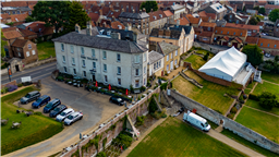
At the core of The Talbot Hotel is a 16th-century private mansion that came to prominence in Malton in the 1660s, at the time of the restoration of the monarchy by King Charles II, and with it the revival in England of the previously banned sport of kings – horse racing.

The North Yorkshire nobility and gentry established Malton as a major centre for horse racing, and for racehorse breeding and training. The mansion that now forms the main part of The Talbot Hotel became an elegant guest house where friends of its owner stayed during the town’s increasingly popular race meetings as well as for fox hunting and hare coursing events. In 1743 the mansion was extensively modernised and converted into a high-class commercial inn, named The Talbot. It became an important coaching inn on the busy road between historic York and Scarborough, the leading port, spa town, and sea-bathing resort. Malton also attracted visitors to its own spa-water spring.

The Watson-Wentworth family, who owned The Talbot as part of their manor of Malton, rose to great prominence in 1765 when Charles Watson-Wentworth, the 2nd Marquess of Rockingham, became Prime Minister. After his death, The Talbot was involved in a great election scandal when the then custodian of the manor, the 4th Earl Fitzwilliam, issued notices to quit to 140 of his Malton tenants who had dared to vote against the earl’s nominees for the town’s two seats in the House of Commons.

Although Malton Races ceased in 1904, The Talbot Hotel continued to be the social hub for the remaining racing community of some of the nation’s top owners, breeders, and trainers. Major expansion of the hotel came after the Second World War, and it was hugely upgraded in 2010 by a £4m refurbishment. The Talbot continues to be owned by the Fitzwilliam Malton Estate and, while under the operational control of the Coaching Inn Group, it supports Malton’s newly emerging reputation as the ‘food capital of Yorkshire’.
Took off from small car park adjecent to small park in Riverside View Post code YO179RB,situated behind the hotel

Land owner permission not required.

View and discuss this location in more detail on Grey Arrows.

Co-ordinates: 54.13381, -0.799776 • what3words: ///readers.twig.shatters

The originator declared that this location was not inside a Flight Restriction Zone at the time of being flown on 06/08/2022. It remains the responsibility of any pilot to check for any changes before flying at the same location.

Where to fly your drone


Recently added locations

Tregoad Holiday Park (By lurch003)

Great place to stay, surrounded by fields and forests, and a great vantage point if you're brave enough to fly towards Looe Island

Land owner permission not required.

View and discuss this location on Grey Arrows.

Co-ordinates: 50.37805, -4.432871 • what3words: ///sectors.tunnel.fruits

Flagstaff Quarry, and The Hoveringham II shipwreck (By Banjonic)

We parked at Penmon Priory and asked the guy in the toll shed if we can get access to the quarry. He gave us the padlock code for the gate so we didn’t have to climb over it. An easy walk across some fields.
There is a ship wreck called the Hoveringham II off the bay which we wanted to get closer to from the quarry.

Land owner permission obtained.

View and discuss this location on Grey Arrows.

Co-ordinates: 53.30466, -4.049213 • what3words: ///waxer.country.takeovers

Kinlochleven overlooking Loch (By Airlessmean)

on the final push of my walk ii had this beautiful view!

Land owner permission not required.

View and discuss this location on Grey Arrows.

Co-ordinates: 56.71656, -4.962602 • what3words: ///digestion.tailing.stewing

Kings house Hotel (By Airlessmean)

bit of kings house in the morning :) nice clouds over the mountain making an awesome atmosphere!

Land owner permission not required.

View and discuss this location on Grey Arrows.

Co-ordinates: 56.652, -4.8401 • what3words: ///accordion.agency.webcams

Bridge of orchy (By Airlessmean)

was a stunning view !

Land owner permission not required.

View and discuss this location on Grey Arrows.

Co-ordinates: 56.51809, -4.770609 • what3words: ///breakaway.pairings.create

island I VOW (By Airlessmean)

passing rowardenan and ivernaid hotel i stopped at a point and captured this stunning little island in the water on the loch lomond

Land owner permission not required.

View and discuss this location on Grey Arrows.

Co-ordinates: 56.27769, -4.696804 • what3words: ///obstruct.vocal.oath

Spud Wood (By AlbionDrones)

Spud Woods in Lymm, park in the free car park, short walk over Grantham's Bridge - over the Bridegwater Canal - and then lots of options as to where to fly.

For a drone meet up turn right and follow the path to the meadow with the picnic bench and 2 other benches and its a nice open field to fly over alongside the woodland and canal - for the adventurous there are the woodland paths to fly through...

Walk straight ahead to the central clering, about 60m wide and about 1/4 mile long, bending left, sheltered between the trees..

Turn left and another much smaller meadow alongside the canal.

Easliy accessible with a shorter walk than Beacon Fell on what appears to be good solid ground.

A good few families walking, and dot walkers, but no-one had issue with the drones being flown, there are no 'no drone' signs, and nothing online I can find - owned by the Woodland Trust, who don't seem to have a drone policy on their website...

Land owner permission requirements unknown.

View and discuss this location on Grey Arrows.

Co-ordinates: 53.38314, -2.448541 • what3words: ///launched.showdown.redouble

Danraven Cliffs (By 20Five)

Dunraven is a great place to visit with the family. Beach, ice cream, castle grounds, woods and cliffside walks.

Parking is currently £5 cash for all day parking. If the main car park is full, which it will be, the warden will guide you to the overflow field which has plenty of spaces.

Wikipedia:
The cliffs are mostly formed of blue lias, a sequence of carboniferous limestone layers from the Triassic period, folded and tilted in places but otherwise level, while Witches Point is composed of Sutton Stone, a lighter-colored limestone which overlays the blue lias and represents an unconformity, with a gap between the two strata of around 150 million years.

Land owner permission not required.

View and discuss this location on Grey Arrows.

Co-ordinates: 51.44084, -3.596313 • what3words: ///treat.sisters.dizziness

Heights of Abraham Matlock (By Woody305)

The Heights of Abraham is a tourist attraction in Derbyshire.

It consists of a hilltop park on top of Masson Hill, accessed from the village by the Heights of Abraham cable car. The heights are named after a supposed resemblance to the Plains of Abraham, also known as the Heights of Abraham, in Quebec, Canada, where James Wolfe died in battle.

Amongst the attractions in the park, which has been open since Victorian times, are cavern and mine tours. There are also views of the dramatic scenery of the valley of the River Derwent. The cable car was opened in 1984 to provide easier access.

The Heights of Abraham are listed as grade II in the register of historic parks and gardens of special historic interest in England.

Land owner permission not required.

View and discuss this location on Grey Arrows.

Co-ordinates: 53.124, -1.554791 • what3words: ///kind.baseballs.activity

St James Church, Coventry (By BudgieUK)

This is a local parish church. The surrounding roads are quite quiet, and parking around the area is easy.

Land owner permission requirements unknown.

View and discuss this location on Grey Arrows.

Co-ordinates: 52.38885, -1.515566 • what3words: ///give.clock.pines


Show All Locations

Service provided by