Where can I fly my drone in the UK and get £5,000,000 Public Liability Insurance cover? Welcome to Drone Scene!

Wondering where you can legally fly your drone? Looking for great places to fly? Looking for £5m Public Liability Insurance cover? Well look no further!

Welcome to Drone Scene, the place to find great drone flying locations in the UK, view images and videos posted by other pilots and share your flying locations in order to help other UK hobbyists find great locations where they can fly safely too.

Click on a marker pin to view details of that location. You can also add comments and discuss the location in our forum.

×You must login to see Airspace Restrictions, National Trust boundaries and other interactive map layers.

Segsbury Camp added to Castles and Fortifications in South East by clinkadink on 16/01/2022

Parked and TOAL where the pin is.

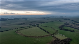
Segsbury Camp or Segsbury Castle, also known as Letcombe Castle, is an Iron Age hill fort on the crest of the Berkshire Downs, near the Ridgeway above Wantage, in the Vale of White Horse district of Oxfordshire, England.

This iron-age hill fort is thought to have been a reasonably large settlement and communal centre for various activities including sheep management and exchange. Today, it is still possible to see the extensive ditch, ramparts and four gateways.

The fort is a short walk from the Ridgeway National Trail, and can be visited as part of the Devil’s Punchbowl and Segsbury Camp Circular walk.

Archeological investigations of Segsbury during the 1990’s revealed a plethora of evidence for human activity in the fort interior and just outside it to the south-west; pits, gullies, post holes, possibly hearths, and finds of iron all suggested that there was a substantial settlement here. The construction of the fort has yet to be dated, although the evidence implies that it began around 6-700 BC with a rampart fronted by a wooden palisade and backed by chalk, which was typical of the era, with two modifications added over the following centuries, the last around 200 BC.

The fort may not have been continuously occupied during this period, but there is evidence to suggest that there was life here at around the time of the Roman Conquest of 43 AD; pottery of the era has been found on the site, and it is possible that the road driven through what is now the southern entrance is Roman in origin.

The fort has extensive ditch and ramparts and four gateways. Excavation at the site by Dr Phené in 1871 discovered a cist grave on the south side of the hill fort rampart. The grave was floored with stone slabs and the sides were walled with flint. Finds included a shield boss and fragments of an urn or drinking cup. Among other finds were human bones and flint scrapers.

It has been suggested that this was a secondary Anglo-Saxon burial, placed at the camp. Further excavation was carried out in 1996 and 1997. The report on this work describes the periodic occupation of the hill fort between the 6th and 2nd centuries BC and suggests that it was a communal centre for various activities, including sheep management and exchange.

https://en.wikipedia.org/wiki/Segsbury_Camp

Land owner permission not required.

View and discuss this location in more detail on Grey Arrows.

Co-ordinates: 51.55802, -1.446562 • what3words: ///thumb.dockers.stubble

The originator declared that this location was not inside a Flight Restriction Zone at the time of being flown on 16/01/2022. It remains the responsibility of any pilot to check for any changes before flying at the same location.

Where to fly your drone


Recently added locations

Blagdon Lake (By richrab)

Blagdon Lake lies in a valley at the northern edge of the Mendip Hills, close to the village of Blagdon and approximately 10 miles (16 km) south of Bristol, England. The lake was created by Bristol Water (Bristol Waterworks Company as it was known then), when it dammed the River Yeo, starting construction in 1898, to designs by Charles Hawksley, and completing this in 1905. The Wrington Vale Light Railway was constructed primarily to bring building materials for the lake.

On the edge of SSI, plenty of birds around the lake, so one to be mindful of.

Land owner permission not required.

View and discuss this location on Grey Arrows.

Co-ordinates: 51.33576, -2.706242 • what3words: ///promoting.throw.cowboys

Burrington Combe (By richrab)

Burrington Combe is a Carboniferous Limestone gorge near the village of Burrington, on the north side of the Mendip Hills Area of Outstanding Natural Beauty, in North Somerset, England.
According to legend Augustus Montague Toplady was inspired to write the hymn Rock of Ages while sheltering under a rock in the combe, although recent scholars have disputed this claim.

The Cobme is in a Amber zone for Scientific or Nature interest.
There is a herd of goats living wild among the rocks.

Land owner permission not required.

View and discuss this location on Grey Arrows.

Co-ordinates: 51.32418, -2.752609 • what3words: ///think.fire.producing

Barrow Tanks (By richrab)

Barrow Gurney Reservoirs (grid reference ST5468) (also known as Barrow Gurney Tanks or Barrow Tanks) are three artificial reservoirs for drinking water near the village of Barrow Gurney, which lies southwest of Bristol, England. They are known by their numbers rather than names.

They are fed by several springs including one which becomes the Land Yeo. Some of the outfall is also used to feed the river which flows to the Bristol Channel.

The Tanks are right on the border of Bristol airport no fly zone.
Parking on the A38 is not practical so TOAL was Dundry Lane.

Land owner permission not required.

View and discuss this location on Grey Arrows.

Co-ordinates: 51.40883, -2.659324 • what3words: ///left.grant.pest

Bruar Woods (By AlbionDrones)

Park at House of Bruar and follow the path towards the falls, turn off before reaching the first bridge for some stunning woodland for a flight

Land owner permission requirements unknown.

View and discuss this location on Grey Arrows.

Co-ordinates: 56.77269, -3.932415 • what3words: ///care.forgives.farmed

Holbeck - Scarborough Southbay (By Paul01)

Great view of Scarborough Southbay from the land formation made when the Holbeck was destroyed in a landslide.

Free parking all year round :-)

Land owner permission requirements unknown.

View and discuss this location on Grey Arrows.

Co-ordinates: 54.26871, -0.390396 • what3words: ///fact.chins.scared

Tilehurst Water Tower (By apreading)

Erected in 1932, Tilehurst Water Tower, is an iconic landmark on the ridge line in Tilehurst, a district in the Western part of Reading. People from Reading know they are near home when they are coming along the M4 from the West and they can see the top of the tower, several miles before they get to Junction 12.

In November 2018 the tower was illuminated in poppy red to mark 100 years since the end of the First World War. The tower remained illuminated, and visible at night from a wide area, until Remembrance Day on 11 November.

It still fulfils its function as a water tower today, and at the top it also houses a number of telephone masts and receivers and also the transmitter for Greatest Hits Radio Berkshire & North Hampshire, a local radio station.

The tower holds a huge 900,000 litres of water, in two 4.5 metre deep tanks and provides around 10 per cent all the water used in Reading, serving 12,000 homes and businesses.

Land owner permission not required.

View and discuss this location on Grey Arrows.

Co-ordinates: 51.45163, -1.047077 • what3words: ///knee.pose.sand

Deangate Ridge Country Park (By RestlessZombi)

This has been the site of many Drone Meetups. Camera Drones, FPV Drones and Fixed Wings have been flown around this area without issue.

Often used by Dog Walkers.

Security Guard is happy with Drones being flown and likes biscuits.

Park in the Car Park for free and walk to site.

Land owner permission not required.

View and discuss this location on Grey Arrows.

Co-ordinates: 51.43191, 0.547509 • what3words: ///skillet.example.forgiven

Scar House Reservoir (By Sleepwalker)

Its a free carpark only about 5 mins away from the first dam if you stick to the left its foot path to the seconed dam but if you dont mind hiking and have appropriate footware then you can do a full circle around the reservoir

Land owner permission requirements unknown.

View and discuss this location on Grey Arrows.

Co-ordinates: 54.1877, -1.907498 • what3words: ///wreck.multiply.recipient

Rhosydd Quarry (By Dren)

Rather wet, muddy walk upto Rhosydd quarry from the Llyn Cwmorthin lake below. Carpark is situated just outside Tanygrisiau, steep narrow roads upto carpark. Gives you an idea of the paths elevation upto plateau. You can fly anywhere here there are no restrictions in the area. Old slate buildings and ruins everywhere

Land owner permission not required.

View and discuss this location on Grey Arrows.

Co-ordinates: 53.00009, -3.978918 • what3words: ///womanly.holly.momentous

Rottingdean (Undercliff Walk) (By Markm0)

You can park in the Marine Cliffs pay and display carpark.

Land owner permission requirements unknown.

View and discuss this location on Grey Arrows.

Co-ordinates: 50.80204, -0.055248 • what3words: ///butter.spud.takeover


Show All Locations

Service provided by