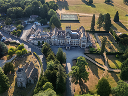
Where can I fly my drone in the UK and get £5,000,000 Public Liability Insurance cover? Welcome to Drone Scene!

Wondering where you can legally fly your drone? Looking for great places to fly? Looking for £5m Public Liability Insurance cover? Well look no further!

Welcome to Drone Scene, the place to find great drone flying locations in the UK, view images and videos posted by other pilots and share your flying locations in order to help other UK hobbyists find great locations where they can fly safely too.

Click on a marker pin to view details of that location. You can also add comments and discuss the location in our forum.

×You must login to see Airspace Restrictions, National Trust boundaries and other interactive map layers.

Where to fly your drone

Filter ()
Cassley (aka Achness) Falls Achness, Lairg, Scotland, Sutherland South (By AlbionDrones)

Perhaps the most beautiful unknown Waterfall in Scotland... Cassley Falls, Achness

Perusing the maps while planning a visit to Raven's Rock Gorge we noticed the nearby notation for the waterfalls of Achness - actually on the signage board as the Cassley Falls - and decided, as we were in the area, we thought we would pay it a short visit.

What a hidden gem of a spot!

There is Car parking for 3 or 4 cars on a single track road, a short 3 to 5 minute walk through beautiful woodland - serenaded by birdsong and teased by the sound of the falls - and then the open vistas of the falls - not massive in height, but the River Cassley is a large river, and the series of falls is both impressive and picturesque.

Add in the fly fisherman seeking Salmon, the sunny day, spring colours on the trees and a perfectly sited bench to sit on, and a relaxing time was had by us all.

I flew with the AVATA2 and AIR3, both of which performed well, there is another set of falls further up the river, perhaps next time we visit we may take a walk up there - we are back in that area on June for a week, although by then I am sure the Midges will be out and looking for targets!

View and discuss this location on Grey Arrows.

Co-ordinates: 57.98836, -4.593042 • what3words: ///flag.apartment.tugging

Wey & Arun Canal. Loxwood canal centre, Chichester (By dandf19)

Loxwood canal centre bewteen Cranleigh and Billingshurst. The canal centre is open for a few hours on Wednesdays, Fridays, Saturdays & Sundays for a few hours. Best to avoid at busy times - plenty walkers, runners, cyclists, ramblers along the tow path. Plenty parkng is via The Onslow Arms - very pleasant looking pub with outside tables overlooking the canal. You can walk in either direction with canal, locks and a few bridges in both directions. Walk some way from the canal centre for variuos TOAL choices.

View and discuss this location on Grey Arrows.

Co-ordinates: 51.07041, -0.517569 • what3words: ///debit.presses.commended

Rousham House & Gardens, West Oxfordshire (By Kirky)

Rousham is completely unspoilt and uncommercialised – One of England’s most important gardens, Rousham represents the first phase of English landscape design and remains almost as its designer William Kent left it. Many of the features that delighted its 18th century visitors are still there for 21st century visitors to enjoy.
A favourite of many great garden designers, in his ‘Around the World in Eighty gardens” Monty Don says “Kent is the great genius of eighteenth-century garden design and Rousham is his masterpiece, one of the greatest gardens in the world”
The house, which has been continuously in the ownership of one family, was built circa 1635 and remodelled by William Kent in the 18th century in a free Gothic style. Further alterations were carried out in the 19th century.
Found this place whilst looking for other locations & it’s a stunning place, gorgeous 360 view surroundings & well worth a visit, was very quiet when I visited although I did speak to one person who seemed very polite & friendly, however I can imagine it gets really busy at peak seasons or weekends, well worth the visit .

View and discuss this location on Grey Arrows.

Co-ordinates: 51.91394, -1.306086 • what3words: ///obscuring.soonest.upward

Souldern Viaduct , Cherwell (By Kirky)

Souldern viaduct is opposite ( other end ) of Aynho viaduct, was out this way doing a couple of other locations so thought id visit Aynho again which is on dronescene when I got chatting to a local nearby as my sat nav kept taking me round in circles & I got lost, on speaking to him about Aynho viaduct he told me there was another one in the opposite direction which confused me as I thought there was only one ( also explains why I went round in circles )

You have to go down wharf lane which is a dead end & farm fields either side so to save confusion if anyone visits,
Souldern is on your left & Aynho is on your right when heading down wharf lane your go over the M40 with the M40 to your back one is on the left the other on the right,
Plenty of places to TOAL & park - stunning views & well worth a visit, was very quiet when I visited weekday midday . You can actually do both viaducts from same TOAL point.

View and discuss this location on Grey Arrows.

Co-ordinates: 51.97378, -1.270509 • what3words: ///beats.piglet.consoles

Manchester United - Trafford Training Centre (By Airlessmean)

Manchester United football club training ground in Carrington – it’s in a unique location with a pleasant surrounding walk and some woodland nearby. I don’t think you can park in the main car park, as I saw workmen coming from the other end of the road.

You can take off from the car park opposite. Just make sure you don’t fly over the tree line — that way, you won’t be encroaching on the "No Drones" area marked for flying over the site.

You can see the whole area clearly from there, including the solar panels in the distance.

View and discuss this location on Grey Arrows.

Co-ordinates: 53.41837, -2.378508 • what3words: ///surfer.replaying.corrects

Henfold, Mole Valley (By grandad1950)

A popular camping and fishing lake in Surrey near Dorking

View and discuss this location on Grey Arrows.

Co-ordinates: 51.1824, -0.29942 • what3words: ///likes.spare.loft

The Eye Catcher , Cherwell (By Kirky)

Came across this place when looking at a location nearby, easy access & lovely surrounding landscapes, there’s a track that goes towards the folly where I parked at the beginning & walked 5 minutes to the folly, a few public about walking their dogs but not that busy when I went ( weekday ) morning,
Could possibly get busier at weekends in all a really nice place & worth a visit,
Wish I had gone a bit later in the day when the sun was lower nonetheless a great place offering plenty of places to TOAL .

The "Eye Catcher" is a historic folly, a sham ruin, located at Steeple Aston in Oxfordshire, England. It was designed by William Kent around 1740 and serves as an important landscape feature at the Ronsham Park estate. The folly is built of Naristone rubble with squared dressings and features arched openings and rubble pinnacles.

View and discuss this location on Grey Arrows.

Co-ordinates: 51.93049, -1.299455 • what3words: ///political.bikers.immediate

Bone Caves of Inchnadamph, Sutherland North and West (By AlbionDrones)

An interesting spot on the NC500, off the beaten track.

The Bone Caves are so named as they contain relics of Eurasian lynx, brown bear, Arctic fox, reindeer (dated to 47,000 BCE), the only evidence of polar bears so far found in Scotland, and human skeletons dated to the 3rd millennium BCE. The skeleton of a bear thought to be 11,000 years old or more was removed from the caves in 2008. The bones were found by cavers in 1995, deep in the Uamh an Claonaite system and have been examined by the National Museums Scotland to determine the age and species. It is presumed the animal died while hibernating, and that its body was later washed further into the underground network.

The route from the free car park is not an easy one, a 4km hike over an uneven rocky path follows the burn up th valley, and then you have 2 choices, the light hand direct up route - very exposed and at times eroded and difficult path, or the longer left hand path that goes past the cave site and winds around the valley at a slightly easier and less exposed ascent.

We went up the rh and came down the lh, given the choice again I would do the LH path every time.

The views are good, the caves not as big as you think at first, but if you have the right gear and torches, then they open out further inside - we didn't go further, were already knackered by the time we arrived, still, the serenity and sacred vibe of the caves made the trip very worthwhile...

Filmed on a Sunday when the EGR610 RAF Low Flying Zone was inactive - hence we could fly drones without issue - this was the day's final stop, followed by the 4KM walk back down to the car - in torrential rain!

View and discuss this location on Grey Arrows.

Co-ordinates: 58.10806, -4.940393 • what3words: ///customers.pacifist.fanfare

St John on the wall, Bristol (By gasbag43)

The Church of St John the Baptist in Bristol, also known as St John on the Wall, is a historic church - the upper church and its medieval vaulted crypt is located at the lower end of Broad Street and is actually built into the old city's medieval walls.

The church was built in the 14th century (and heavily modified in the 19th century) with the tower and steeple over St John's Gate, the last remaining city gateway. The church is very narrow as it is built into and alongside the city walls. Consequently, it is also known as St John's on the Wall.

Im not normally a fan of using a drone to photograph buildings in inner city locations, but what makes this different for me is its location which is slap bang in the middle of large, well known pieces of street art (several of which ive included in the photo of the church on the office blocks behind it)

Broad Street in Bristol is known for a variety of street art, including the work of Conor Harrington, who uses a blend of contemporary and classical styles. The street also features more general graffiti and urban art. The area around Broad Street is part of a broader street art scene that includes Stokes Croft, Southville, and Bedminster.


The area is worth a drone’s-eye view of the art painted high on the nearby buildings, but there are impressive pieces of work at ground level (including a couple of nearby Banksy pieces) – several walking tours of Bristol street art are advertised online and worth a look if this is something that interests you

View and discuss this location on Grey Arrows.

Co-ordinates: 51.45596, -2.595037 • what3words: ///audio.dress.dinner

Cabot Tower, Bristol (By gasbag43)

Cabot Tower is situated in a public park on Brandon Hill, between the city centre, Clifton and Hotwells. It is a grade II listed building.

The tower was built in the 1890s to commemorate the 400th anniversary of the journey of John Cabot from Bristol to land which later became Canada.

The tower is 105 feet (32 m) high and built from red sandstone with cream Bath Stone for ornamentation and emphasis. It consists of a spiral staircase and two viewing platforms where balconies with wrought iron railings overlook the city, the higher of which is approximately 334 feet (102 m) above sea level.

View and discuss this location on Grey Arrows.

Co-ordinates: 51.45374, -2.606914 • what3words: ///plot.solved.bags


Show All Locations

Service provided by