Where can I fly my drone in the UK and get £5,000,000 Public Liability Insurance cover? Welcome to Drone Scene!

Wondering where you can legally fly your drone? Looking for great places to fly? Looking for £5m Public Liability Insurance cover? Well look no further!

Welcome to Drone Scene, the place to find great drone flying locations in the UK, view images and videos posted by other pilots and share your flying locations in order to help other UK hobbyists find great locations where they can fly safely too.

Click on a marker pin to view details of that location. You can also add comments and discuss the location in our forum.

×You must login to see Airspace Restrictions, National Trust boundaries and other interactive map layers.

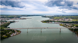
Cleddau Bridge added to Bridges in Wales by clinkadink on 29/09/2023

Parking & TOAL: 51.701730, -4.931898

About 100 m from my folks house, where I where brought up. I used to jump into the cage under the bridge with my mates in the late 70's, and run the full length of the bridge and back - wicked.

That said - this bridge, whilst not anything like the Severn or Humber, has a lot of history - and not all good.

On June 2, 1970, disaster struck the small village of Pembroke Ferry, when a 150 tonne section of the part-built Cleddau Bridge collapsed, killing four men and injuring another 5 people.

At 2.16pm BST, as a section of the bridge was lowered onto the supporting structure below, villagers reported hearing a groaning sound followed by an engulfing cloud of red dust.

The first officer on the scene was dad of two, PC Phil Lloyd, having just clocked into his shift at Pembroke Dock Station when the fire siren sounded.

Recalling the day, Phil, 74 said “I presumed it was just another chimney fire.”

Then at 2.20pm Phil received a call from his mother in law, she lived 30 metres below the bridge.

“When I went into the switchboard the fella said ‘your mother-in-law is on the phone’.”

“She shouted, ‘the bridge has come down!’ and i said ‘don’t be so dull’.”

PC Lloyd’s mother-in-law, Ivy Lewis, lived directly under the bridge, in Pembroke Ferry, on the south side of the river.

With the oil refineries, Milford Haven Port, all being developed in the county, the bridge was a much needed asset, which would give better accessibility and cut down the 20-mile round trip for vehicles.

Arriving at the scene, Phil described it as “utter pandemonium”.

At the time of the collapse, the local gas man was attending Mrs Lewis’ property. She originally assumed that he “had blown the house up”.

It was only when stepping into her garden could she fathom the true cause of the commotion. The whole section of the bridge was resting at a 45-degree angle in her garden.

Astonishly the bridge narrowly missed the below properties. Although it had completely demolished Phil’s aunties coal shed and outdoor toilet.

“Luckily there was a gap between her house and her sister’s house which is where the bridge came down.” Phil said.

“One man had been killed at the scene and two others were taken to hospital but died later. Then when the bridge was lifted, we found another man underneath.”

Construction of the box-section bridge was put on halt immediately.

Within 18 month’s bridges in Germany and Australia, both of the same ill-fated design collapsed with fatal consequences.

The cause of the collapse was later revealed that the diaphragm above the pier of the bridge had not been thick enough and buckled as the 230-foot section was cantilevered out.

Following an inquiry, a number of safety recommendations were made, which included the addition of 500ft of extra steel to strengthen the bridge.

In 1995, on the 25th anniversary of the disaster a memorial plaque to the four men who died, William Baxendale, George Hamilton, James Thompson and local man Evan Phillips.was unveiled.

Unfortunately the plaque was later stolen and has not yet been replaced.

The completed Cleddau Bridge reopened in 1975, making it the largest unsupported span in Europe although costs had escalated to £12m upon completion.

The disaster which shook the small village, laid the foundations for which a new standard was developed in the box girder bridge design.

The Cleddau collapse was regarded as the last major bridge disaster in the UK.

https://en.wikipedia.org/wiki/Cleddau_Bridge

Land owner permission not required.

View and discuss this location in more detail on Grey Arrows.

Co-ordinates: 51.70626, -4.933596 • what3words: ///flaking.chaos.rewarded

The originator declared that this location was not inside a Flight Restriction Zone at the time of being flown on 07/09/2023. It remains the responsibility of any pilot to check for any changes before flying at the same location.

Where to fly your drone


Recently added locations

Drakeholes (By Woody305)

The Duck At Drakeholes. Lovely spot to see Narrow Boats on the Chesterfield Canal and have a cool drink or a bite to eat. TOAL was parked up at side of Wiseton Road.Clear LOS

Land owner permission not required.

View and discuss this location on Grey Arrows.

Co-ordinates: 53.40559, -0.938813 • what3words: ///helpers.pots.supposing

Denbigh Asylum Ruins (By Dren)

Flew here today after much research, no actual access to site as is actively protected by security guards hiding in building wearing kharki, combat clothing was reported on other sites this their attitude to combat trespass. My drone did draw two guards out of cover whilst hovering above incredible old building in poor disrepute.

Land owner permission requirements unknown.

View and discuss this location on Grey Arrows.

Co-ordinates: 53.17417, -3.421029 • what3words: ///hippy.divided.hillsides

Gamelands stone circle (By markas)

Gamelands stone circle lies between the village of Orton and the hamlet of Raisbeck. It is an oval enclosure of around 40 large stones, all of which have fallen, together with three smaller stones. The stones are set into a slight bank. All of the stones are of pink granite with the exception of one which is limestone. The stones are all below one metre in height and are arranged in an oval of 42 metres by 35 metres.

Land owner permission requirements unknown.

View and discuss this location on Grey Arrows.

Co-ordinates: 54.46751, -2.556853 • what3words: ///bonkers.ghosts.opposing

Teignmouth (By richrab)

Teignmouth is a seaside town, fishing port and civil parish in the English county of Devon. It is on the north bank of the estuary mouth of the River Teign, about 12 miles (19 km) south of Exeter.

Parked Car and TOAL from the Ness Car park.

Land owner permission not required.

View and discuss this location on Grey Arrows.

Co-ordinates: 50.53737, -3.499931 • what3words: ///emporium.screeches.breathing

Paignton - Devon (By richrab)

Paignton is a seaside town on the coast of Tor Bay in Devon, England. Together with Torquay and Brixham it forms the borough of Torbay which was created in 1968. The Torbay area is a holiday destination known as the English Riviera.

TOAL from a Bench on the promenade.
Last week in March so not many people about.

Land owner permission not required.

View and discuss this location on Grey Arrows.

Co-ordinates: 50.43277, -3.558799 • what3words: ///among.keeps.brass

Dartmouth - Devon (By richrab)

Dartmouth is a town and civil parish in the English county of Devon. It is a tourist destination set on the western bank of the estuary of the River Dart, which is a long narrow tidal ria that runs inland as far as Totnes. It lies within the South Devon Area of Outstanding Natural Beauty.

TOAL and Parking was on Higher Contour Road. ///roofed.clenching.glider

Land owner permission not required.

View and discuss this location on Grey Arrows.

Co-ordinates: 50.3489, -3.568722 • what3words: ///sings.rezoning.fists

Loch Dunmore, Faskally Forest, Perthshire (By AlbionDrones)

Park up at the Forestry Commission car park - there is a charge, but also toilets - and walk the short distance to the loch to find a spot for TOAL, we chose the path near the bridge and flew from there.

It can get busy at certain times of day and year, especially when the Fantasy Forest is on in the Autumn, but definitely worth a stop, the reflections are awesome in the sheltered and still water...

Land owner permission requirements unknown.

View and discuss this location on Grey Arrows.

Co-ordinates: 56.71111, -3.765409 • what3words: ///galloped.pouch.store

Blagdon Lake (By richrab)

Blagdon Lake lies in a valley at the northern edge of the Mendip Hills, close to the village of Blagdon and approximately 10 miles (16 km) south of Bristol, England. The lake was created by Bristol Water (Bristol Waterworks Company as it was known then), when it dammed the River Yeo, starting construction in 1898, to designs by Charles Hawksley, and completing this in 1905. The Wrington Vale Light Railway was constructed primarily to bring building materials for the lake.

On the edge of SSI, plenty of birds around the lake, so one to be mindful of.

Land owner permission not required.

View and discuss this location on Grey Arrows.

Co-ordinates: 51.33576, -2.706242 • what3words: ///promoting.throw.cowboys

Burrington Combe (By richrab)

Burrington Combe is a Carboniferous Limestone gorge near the village of Burrington, on the north side of the Mendip Hills Area of Outstanding Natural Beauty, in North Somerset, England.
According to legend Augustus Montague Toplady was inspired to write the hymn Rock of Ages while sheltering under a rock in the combe, although recent scholars have disputed this claim.

The Cobme is in a Amber zone for Scientific or Nature interest.
There is a herd of goats living wild among the rocks.

Land owner permission not required.

View and discuss this location on Grey Arrows.

Co-ordinates: 51.32418, -2.752609 • what3words: ///think.fire.producing

Barrow Tanks (By richrab)

Barrow Gurney Reservoirs (grid reference ST5468) (also known as Barrow Gurney Tanks or Barrow Tanks) are three artificial reservoirs for drinking water near the village of Barrow Gurney, which lies southwest of Bristol, England. They are known by their numbers rather than names.

They are fed by several springs including one which becomes the Land Yeo. Some of the outfall is also used to feed the river which flows to the Bristol Channel.

The Tanks are right on the border of Bristol airport no fly zone.
Parking on the A38 is not practical so TOAL was Dundry Lane.

Land owner permission not required.

View and discuss this location on Grey Arrows.

Co-ordinates: 51.40883, -2.659324 • what3words: ///left.grant.pest


Show All Locations

Service provided by