Where can I fly my drone in the UK and get £5,000,000 Public Liability Insurance cover? Welcome to Drone Scene!

Wondering where you can legally fly your drone? Looking for great places to fly? Looking for £5m Public Liability Insurance cover? Well look no further!

Welcome to Drone Scene, the place to find great drone flying locations in the UK, view images and videos posted by other pilots and share your flying locations in order to help other UK hobbyists find great locations where they can fly safely too.

Click on a marker pin to view details of that location. You can also add comments and discuss the location in our forum.

×You must login to see Airspace Restrictions, National Trust boundaries and other interactive map layers.

Cleddau Bridge added to Bridges in Wales by clinkadink on 29/09/2023

Parking & TOAL: 51.701730, -4.931898

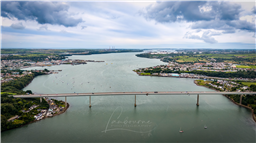
About 100 m from my folks house, where I where brought up. I used to jump into the cage under the bridge with my mates in the late 70's, and run the full length of the bridge and back - wicked.

That said - this bridge, whilst not anything like the Severn or Humber, has a lot of history - and not all good.

On June 2, 1970, disaster struck the small village of Pembroke Ferry, when a 150 tonne section of the part-built Cleddau Bridge collapsed, killing four men and injuring another 5 people.

At 2.16pm BST, as a section of the bridge was lowered onto the supporting structure below, villagers reported hearing a groaning sound followed by an engulfing cloud of red dust.

The first officer on the scene was dad of two, PC Phil Lloyd, having just clocked into his shift at Pembroke Dock Station when the fire siren sounded.

Recalling the day, Phil, 74 said “I presumed it was just another chimney fire.”

Then at 2.20pm Phil received a call from his mother in law, she lived 30 metres below the bridge.

“When I went into the switchboard the fella said ‘your mother-in-law is on the phone’.”

“She shouted, ‘the bridge has come down!’ and i said ‘don’t be so dull’.”

PC Lloyd’s mother-in-law, Ivy Lewis, lived directly under the bridge, in Pembroke Ferry, on the south side of the river.

With the oil refineries, Milford Haven Port, all being developed in the county, the bridge was a much needed asset, which would give better accessibility and cut down the 20-mile round trip for vehicles.

Arriving at the scene, Phil described it as “utter pandemonium”.

At the time of the collapse, the local gas man was attending Mrs Lewis’ property. She originally assumed that he “had blown the house up”.

It was only when stepping into her garden could she fathom the true cause of the commotion. The whole section of the bridge was resting at a 45-degree angle in her garden.

Astonishly the bridge narrowly missed the below properties. Although it had completely demolished Phil’s aunties coal shed and outdoor toilet.

“Luckily there was a gap between her house and her sister’s house which is where the bridge came down.” Phil said.

“One man had been killed at the scene and two others were taken to hospital but died later. Then when the bridge was lifted, we found another man underneath.”

Construction of the box-section bridge was put on halt immediately.

Within 18 month’s bridges in Germany and Australia, both of the same ill-fated design collapsed with fatal consequences.

The cause of the collapse was later revealed that the diaphragm above the pier of the bridge had not been thick enough and buckled as the 230-foot section was cantilevered out.

Following an inquiry, a number of safety recommendations were made, which included the addition of 500ft of extra steel to strengthen the bridge.

In 1995, on the 25th anniversary of the disaster a memorial plaque to the four men who died, William Baxendale, George Hamilton, James Thompson and local man Evan Phillips.was unveiled.

Unfortunately the plaque was later stolen and has not yet been replaced.

The completed Cleddau Bridge reopened in 1975, making it the largest unsupported span in Europe although costs had escalated to £12m upon completion.

The disaster which shook the small village, laid the foundations for which a new standard was developed in the box girder bridge design.

The Cleddau collapse was regarded as the last major bridge disaster in the UK.

https://en.wikipedia.org/wiki/Cleddau_Bridge

Land owner permission not required.

View and discuss this location in more detail on Grey Arrows.

Co-ordinates: 51.70626, -4.933596 • what3words: ///flaking.chaos.rewarded

The originator declared that this location was not inside a Flight Restriction Zone at the time of being flown on 07/09/2023. It remains the responsibility of any pilot to check for any changes before flying at the same location.

Where to fly your drone


Recently added locations

Marsh Road Spalding (By Sammie99)

Drive as far down Marsh Road as you can. There are two concrete areas either side of the road which provide handy parking, watch out for the power lines over head. I don't know what this building's function is or was, I just thought it looked interesting.

Land owner permission not required.

View and discuss this location on Grey Arrows.

Co-ordinates: 52.8552, -0.07247 • what3words: ///require.pens.remaining

Victoria Park, Haywards Heath (By grandad1950)

I didn't expect the fair to be there but it makes a good image.

The park is used for many events throughout the year and gives good views across the town.

Land owner permission requirements unknown.

View and discuss this location on Grey Arrows.

Co-ordinates: 50.99792, -0.104573 • what3words: ///deals.flank.next

Braemar, Highland Scotland (By AlbionDrones)

The small town/village of Braemar, bisected by the Vlune Water, and nestled in the Cairngorm.

Sdly it as extremely windy on ou visit, so I only managed a short flight, but the river is stunning, there are plenty of historic buildings, and being surrounded by woodland and mountains - with a Caastle in the distance it makes for a fine subject...

There are good car parking options, a few decent shops to look around and several TOAL options, marked on the map, feel free to ad other markers as you find them...

Land owner permission requirements unknown.

View and discuss this location on Grey Arrows.

Co-ordinates: 57.00579, -3.399294 • what3words: ///generated.firms.losses

Dalnaglar Castle, Glen Shee (By AlbionDrones)

A stunning Baronial Castle glimpsed from the roadside.

Park up in the car park for the Clach na Coileach, and you can see the castle at about 500m away, behind some trees. Best approach would be to fly a little down the glen, then turn and fly up to the castle, with it being visible rather than being hidden by trees, but as can be seen I was chancing the mizzly weather, so wanted to keep the flight time to an absolute minimum...

Land owner permission requirements unknown.

View and discuss this location on Grey Arrows.

Co-ordinates: 56.76612, -3.398931 • what3words: ///teeth.gracing.mystified

Wakefield Cathedral (By richrab)

Wakefield Cathedral, or the Cathedral Church of All Saints in Wakefield, West Yorkshire, England, is a co-equal Anglican cathedral with Bradford and Ripon Cathedrals, in the Diocese of Leeds and a seat of the Bishop of Leeds. Originally the parish church, it has Anglo Saxon origins and, after enlargement and rebuilding, has the tallest spire in Yorkshire. Its 247-foot (75 m) spire is the tallest structure in the City of Wakefield. The cathedral was designated a Grade I listed building on 14 July 1953.

In a pedestrian zone, there is a lane and small courtyard just behind, Marked as TOAL point.

There is a RED FRZ in place but upon looking it is Helicopters only.
This area is close to the Prison FRZ so don't fly west from here.

Land owner permission not required.

View and discuss this location on Grey Arrows.

Co-ordinates: 53.68299, -1.496811 • what3words: ///guard.weep.rider

Tregoad Holiday Park (By lurch003)

Great place to stay, surrounded by fields and forests, and a great vantage point if you're brave enough to fly towards Looe Island

Land owner permission not required.

View and discuss this location on Grey Arrows.

Co-ordinates: 50.37805, -4.432871 • what3words: ///sectors.tunnel.fruits

Kinlochleven overlooking Loch (By Airlessmean)

on the final push of my walk ii had this beautiful view!

Land owner permission not required.

View and discuss this location on Grey Arrows.

Co-ordinates: 56.71656, -4.962602 • what3words: ///digestion.tailing.stewing

Kings house Hotel (By Airlessmean)

bit of kings house in the morning :) nice clouds over the mountain making an awesome atmosphere!

Land owner permission not required.

View and discuss this location on Grey Arrows.

Co-ordinates: 56.652, -4.8401 • what3words: ///accordion.agency.webcams

Bridge of orchy (By Airlessmean)

was a stunning view !

Land owner permission not required.

View and discuss this location on Grey Arrows.

Co-ordinates: 56.51809, -4.770609 • what3words: ///breakaway.pairings.create

island I VOW (By Airlessmean)

passing rowardenan and ivernaid hotel i stopped at a point and captured this stunning little island in the water on the loch lomond

Land owner permission not required.

View and discuss this location on Grey Arrows.

Co-ordinates: 56.27769, -4.696804 • what3words: ///obstruct.vocal.oath


Show All Locations

Service provided by