Where can I fly my drone in the UK and get £5,000,000 Public Liability Insurance cover? Welcome to Drone Scene!

Wondering where you can legally fly your drone? Looking for great places to fly? Looking for £5m Public Liability Insurance cover? Well look no further!

Welcome to Drone Scene, the place to find great drone flying locations in the UK, view images and videos posted by other pilots and share your flying locations in order to help other UK hobbyists find great locations where they can fly safely too.

Click on a marker pin to view details of that location. You can also add comments and discuss the location in our forum.

×You must login to see Airspace Restrictions, National Trust boundaries and other interactive map layers.

Tenby Castle added to Historic Buildings in Wales by clinkadink on 29/09/2023

Parking: 51.671225, -4.703398
TOAL: 51.672866, -4.695374

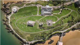
High on a hill above Tenby harbour stand the remains of 13th century castle walls along with a ruined gate and tower. The first castle here was built by an unknown Norman lord sometime before 1153, when it was captured by the Welsh under Lord Rhys. That first castle was defended by earthen banks and ditches. It may stand on the site of a yet earlier castle founded by the Welsh in the 9th century.
The castle was built on a promontory joined to the mainland by a narrow neck of land, and linked to the medieval town walls. The most prominent features of the castle are the D-shaped gatehouse, with barbican defences, and the stump of a stone keep with a stair turret.

The castle defences were strengthened in 1377, but just 9 years later an enquiry found the fortress suffering from neglect, with work needed on the roof timber and leading. It seems efforts to maintain the castle were sporadic at best.

During the Civil War the castle was held by a band of Royalist soldiers for 10 weeks. The Royalists were starved into submission by Parliament.

In 1832 one of the medieval residential buildings beside the gatehouse was transformed into a National School. The building was enlarged a decade later, but closed in 1874. In 1878 the school building was altered once more to serve as the Tenby Museum and Art Gallery. The museum boasts displays on the archaeology, geology, maritime, and natural history of the Tenby area, plus local art and exhibits relating to the Castlemartin (Pembrokeshire) Yeomanry.

In 1865 the space within the castle was drastically altered when an imposing statue of Prince Albert was added at its highest point. Prince Arthur, eldest son of Prince Albert and Queen Victoria, unveiled the statue on 2 August 1865. Just beyond the statue is the Watchtower, built in the 13th century. This consists of a round tower linked to a later staircase tower. It was used by the Admiralty for many years but is now home to a Met Office weather station.

The castle remains include the smallest 'great tower' of any castle in Wales, and may have been inspired by the great tower at Pembroke Castle. Only small sections of the castle walls remain intact. On the north side is a small stretch of wall with medieval arrow slits and a section of the wall walk. You approach the castle through a very simple gate through the curtain wall, defended by a small barbican, leading to the museum.

Also on Castle Hill is The Old Coastguard House, built in the early 19th century as a coastguard station. There are also several old cannons on Castle Hill. These originally formed part of the town defences. They were restored and remounted in the 1960s by the Royal Regiment of Artillery and the Corps of Royal Electrical and Mechanical Engineers from the School of Artillery at Manorbier.

From the late 18th century Castle Hill was a fashionable area for Tenby natives and visitors to promenade and take the views. From 1897 they could also listen to open-air concerts from the Bandstand. The original bandstand was dismantled so its metal could be used for the WWII war effort. It was restored in 1991.

THE TOWN WALLS
Tenby's medieval walls are very well preserved, and indeed may be considered of greater historical interest than the rather scanty castle ruins.

Tenby was sacked by Rhys's son Maelgwyn in 1187, and again by Llewelyn ap Gruffudd in 1260. To add an extra measure of defence the extensive town walls were built by the Norman lord William de Valence. The walls served their purpose, saving Tenby from an attack by Owain Glyndwr's French allies in 1405.

In 1873 the town council wanted to pull down the medieval walls, but were prevented by the efforts of a certain Dr Chater. As a result, we can get a good idea of what most Welsh medieval town walls would have looked like (leaving aside the very grand and extensive walls at major centres like Caernarfon and Conwy).

Castle Hill is very easy to reach from the harbour and is well signposted from around the town. There is no parking on the site, but there are several pay and display parking areas near the harbour.

https://en.wikipedia.org/wiki/Tenby_Castle

Land owner permission not required.

View and discuss this location in more detail on Grey Arrows.

Co-ordinates: 51.67255, -4.694564 • what3words: ///hems.rationing.centuries

The originator declared that this location was not inside a Flight Restriction Zone at the time of being flown on 06/08/2023. It remains the responsibility of any pilot to check for any changes before flying at the same location.

Where to fly your drone


Recently added locations

Marsh Road Spalding (By Sammie99)

Drive as far down Marsh Road as you can. There are two concrete areas either side of the road which provide handy parking, watch out for the power lines over head. I don't know what this building's function is or was, I just thought it looked interesting.

Land owner permission not required.

View and discuss this location on Grey Arrows.

Co-ordinates: 52.8552, -0.07247 • what3words: ///require.pens.remaining

Victoria Park, Haywards Heath (By grandad1950)

I didn't expect the fair to be there but it makes a good image.

The park is used for many events throughout the year and gives good views across the town.

Land owner permission requirements unknown.

View and discuss this location on Grey Arrows.

Co-ordinates: 50.99792, -0.104573 • what3words: ///deals.flank.next

Braemar, Highland Scotland (By AlbionDrones)

The small town/village of Braemar, bisected by the Vlune Water, and nestled in the Cairngorm.

Sdly it as extremely windy on ou visit, so I only managed a short flight, but the river is stunning, there are plenty of historic buildings, and being surrounded by woodland and mountains - with a Caastle in the distance it makes for a fine subject...

There are good car parking options, a few decent shops to look around and several TOAL options, marked on the map, feel free to ad other markers as you find them...

Land owner permission requirements unknown.

View and discuss this location on Grey Arrows.

Co-ordinates: 57.00579, -3.399294 • what3words: ///generated.firms.losses

Dalnaglar Castle, Glen Shee (By AlbionDrones)

A stunning Baronial Castle glimpsed from the roadside.

Park up in the car park for the Clach na Coileach, and you can see the castle at about 500m away, behind some trees. Best approach would be to fly a little down the glen, then turn and fly up to the castle, with it being visible rather than being hidden by trees, but as can be seen I was chancing the mizzly weather, so wanted to keep the flight time to an absolute minimum...

Land owner permission requirements unknown.

View and discuss this location on Grey Arrows.

Co-ordinates: 56.76612, -3.398931 • what3words: ///teeth.gracing.mystified

Wakefield Cathedral (By richrab)

Wakefield Cathedral, or the Cathedral Church of All Saints in Wakefield, West Yorkshire, England, is a co-equal Anglican cathedral with Bradford and Ripon Cathedrals, in the Diocese of Leeds and a seat of the Bishop of Leeds. Originally the parish church, it has Anglo Saxon origins and, after enlargement and rebuilding, has the tallest spire in Yorkshire. Its 247-foot (75 m) spire is the tallest structure in the City of Wakefield. The cathedral was designated a Grade I listed building on 14 July 1953.

In a pedestrian zone, there is a lane and small courtyard just behind, Marked as TOAL point.

There is a RED FRZ in place but upon looking it is Helicopters only.
This area is close to the Prison FRZ so don't fly west from here.

Land owner permission not required.

View and discuss this location on Grey Arrows.

Co-ordinates: 53.68299, -1.496811 • what3words: ///guard.weep.rider

Tregoad Holiday Park (By lurch003)

Great place to stay, surrounded by fields and forests, and a great vantage point if you're brave enough to fly towards Looe Island

Land owner permission not required.

View and discuss this location on Grey Arrows.

Co-ordinates: 50.37805, -4.432871 • what3words: ///sectors.tunnel.fruits

Kinlochleven overlooking Loch (By Airlessmean)

on the final push of my walk ii had this beautiful view!

Land owner permission not required.

View and discuss this location on Grey Arrows.

Co-ordinates: 56.71656, -4.962602 • what3words: ///digestion.tailing.stewing

Kings house Hotel (By Airlessmean)

bit of kings house in the morning :) nice clouds over the mountain making an awesome atmosphere!

Land owner permission not required.

View and discuss this location on Grey Arrows.

Co-ordinates: 56.652, -4.8401 • what3words: ///accordion.agency.webcams

Bridge of orchy (By Airlessmean)

was a stunning view !

Land owner permission not required.

View and discuss this location on Grey Arrows.

Co-ordinates: 56.51809, -4.770609 • what3words: ///breakaway.pairings.create

island I VOW (By Airlessmean)

passing rowardenan and ivernaid hotel i stopped at a point and captured this stunning little island in the water on the loch lomond

Land owner permission not required.

View and discuss this location on Grey Arrows.

Co-ordinates: 56.27769, -4.696804 • what3words: ///obstruct.vocal.oath


Show All Locations

Service provided by