Where can I fly my drone in the UK and get £5,000,000 Public Liability Insurance cover? Welcome to Drone Scene!

Wondering where you can legally fly your drone? Looking for great places to fly? Looking for £5m Public Liability Insurance cover? Well look no further!

Welcome to Drone Scene, the place to find great drone flying locations in the UK, view images and videos posted by other pilots and share your flying locations in order to help other UK hobbyists find great locations where they can fly safely too.

Click on a marker pin to view details of that location. You can also add comments and discuss the location in our forum.

×You must login to see Airspace Restrictions, National Trust boundaries and other interactive map layers.

Casterley Camp added to Castles and Fortifications in South West by clinkadink on 26/02/2023

Parking & TOAL: 51.282268, -1.839873

I parked in the free car park and TOAL'd from there. Note, the eastern edge of the camp is within Upavon FRZ, hence TOAL from the car park, which is outside. However, the camp and surrounding area is in Larkhill danger area, so be aware of your surroundings if flying here.

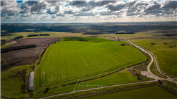
Casterley Camp is an Iron Age univallate hillfort in Wiltshire. The site comprises a large Iron Age/Romano-British enclosure, possibly non-defensive in function, and incomplete. The site was partially excavated in the 19th century.

There are many indications of prehistoric settlement. There was substantial activity on the downs in Neolithic and Bronze Age times and finds include an axe and arrowheads at Casterley Camp.

Casterley Camp itself is probably the earliest settlement and must have been communal with several families living here in the Iron Age. The village, founded in the early Iron Age, was enclosed by a bank and ditch that wsa pierced by three entrances. It is a large site and there were separate enclosures within this bank. The site was occupied throughout the period and much pottery and many implements were found by the Cunningtons in excavation here. These included a spearhead and hammer head, brooches, a button and saddle querns for grinding corn. The pottery included locally made utensils and items imported from present day French and Belgium. The central complex, probably the settlement itself, covers nine acres and this is surrounded by ditched enclosures, opening out of one another, in the 62 acres enclosed by the outer bank.

Occupation of Casterley Camp continued throughout the Roman period and finds include Samian ware pottery, coins from Claudius to Constantine, and items such as pins, bronze earpicks, tweezers, iron knives, nails and brooches.

https://en.wikipedia.org/wiki/Casterley_Camp

Land owner permission not required.

View and discuss this location in more detail on Grey Arrows.

Co-ordinates: 51.28065, -1.83548 • what3words: ///confusion.starch.available

The originator declared that this location was not inside a Flight Restriction Zone at the time of being flown on 26/02/2023. It remains the responsibility of any pilot to check for any changes before flying at the same location.

Where to fly your drone


Recently added locations

Marsh Road Spalding (By Sammie99)

Drive as far down Marsh Road as you can. There are two concrete areas either side of the road which provide handy parking, watch out for the power lines over head. I don't know what this building's function is or was, I just thought it looked interesting.

Land owner permission not required.

View and discuss this location on Grey Arrows.

Co-ordinates: 52.8552, -0.07247 • what3words: ///require.pens.remaining

Victoria Park, Haywards Heath (By grandad1950)

I didn't expect the fair to be there but it makes a good image.

The park is used for many events throughout the year and gives good views across the town.

Land owner permission requirements unknown.

View and discuss this location on Grey Arrows.

Co-ordinates: 50.99792, -0.104573 • what3words: ///deals.flank.next

Braemar, Highland Scotland (By AlbionDrones)

The small town/village of Braemar, bisected by the Vlune Water, and nestled in the Cairngorm.

Sdly it as extremely windy on ou visit, so I only managed a short flight, but the river is stunning, there are plenty of historic buildings, and being surrounded by woodland and mountains - with a Caastle in the distance it makes for a fine subject...

There are good car parking options, a few decent shops to look around and several TOAL options, marked on the map, feel free to ad other markers as you find them...

Land owner permission requirements unknown.

View and discuss this location on Grey Arrows.

Co-ordinates: 57.00579, -3.399294 • what3words: ///generated.firms.losses

Dalnaglar Castle, Glen Shee (By AlbionDrones)

A stunning Baronial Castle glimpsed from the roadside.

Park up in the car park for the Clach na Coileach, and you can see the castle at about 500m away, behind some trees. Best approach would be to fly a little down the glen, then turn and fly up to the castle, with it being visible rather than being hidden by trees, but as can be seen I was chancing the mizzly weather, so wanted to keep the flight time to an absolute minimum...

Land owner permission requirements unknown.

View and discuss this location on Grey Arrows.

Co-ordinates: 56.76612, -3.398931 • what3words: ///teeth.gracing.mystified

Wakefield Cathedral (By richrab)

Wakefield Cathedral, or the Cathedral Church of All Saints in Wakefield, West Yorkshire, England, is a co-equal Anglican cathedral with Bradford and Ripon Cathedrals, in the Diocese of Leeds and a seat of the Bishop of Leeds. Originally the parish church, it has Anglo Saxon origins and, after enlargement and rebuilding, has the tallest spire in Yorkshire. Its 247-foot (75 m) spire is the tallest structure in the City of Wakefield. The cathedral was designated a Grade I listed building on 14 July 1953.

In a pedestrian zone, there is a lane and small courtyard just behind, Marked as TOAL point.

There is a RED FRZ in place but upon looking it is Helicopters only.
This area is close to the Prison FRZ so don't fly west from here.

Land owner permission not required.

View and discuss this location on Grey Arrows.

Co-ordinates: 53.68299, -1.496811 • what3words: ///guard.weep.rider

Tregoad Holiday Park (By lurch003)

Great place to stay, surrounded by fields and forests, and a great vantage point if you're brave enough to fly towards Looe Island

Land owner permission not required.

View and discuss this location on Grey Arrows.

Co-ordinates: 50.37805, -4.432871 • what3words: ///sectors.tunnel.fruits

Kinlochleven overlooking Loch (By Airlessmean)

on the final push of my walk ii had this beautiful view!

Land owner permission not required.

View and discuss this location on Grey Arrows.

Co-ordinates: 56.71656, -4.962602 • what3words: ///digestion.tailing.stewing

Kings house Hotel (By Airlessmean)

bit of kings house in the morning :) nice clouds over the mountain making an awesome atmosphere!

Land owner permission not required.

View and discuss this location on Grey Arrows.

Co-ordinates: 56.652, -4.8401 • what3words: ///accordion.agency.webcams

Bridge of orchy (By Airlessmean)

was a stunning view !

Land owner permission not required.

View and discuss this location on Grey Arrows.

Co-ordinates: 56.51809, -4.770609 • what3words: ///breakaway.pairings.create

island I VOW (By Airlessmean)

passing rowardenan and ivernaid hotel i stopped at a point and captured this stunning little island in the water on the loch lomond

Land owner permission not required.

View and discuss this location on Grey Arrows.

Co-ordinates: 56.27769, -4.696804 • what3words: ///obstruct.vocal.oath


Show All Locations

Service provided by