Where can I fly my drone in the UK and get £5,000,000 Public Liability Insurance cover? Welcome to Drone Scene!

Wondering where you can legally fly your drone? Looking for great places to fly? Looking for £5m Public Liability Insurance cover? Well look no further!

Welcome to Drone Scene, the place to find great drone flying locations in the UK, view images and videos posted by other pilots and share your flying locations in order to help other UK hobbyists find great locations where they can fly safely too.

Click on a marker pin to view details of that location. You can also add comments and discuss the location in our forum.

×You must login to see Airspace Restrictions, National Trust boundaries and other interactive map layers.

Sudeley Castle added to Castles and Fortifications in South West by clinkadink on 22/01/2023

Parking: 51.951392, -1.966314
TOAL: 51.946815, -1.958124

The castle is 1km southeast of Winchcombe and can be accessed from either Vineyard Street or Castle Street. The castle is currently closed, so I couldn't access the car park next to the castle. Instead I parked on Vineyard street and walked up the road, past the Gatehouse and across Beesmoor Brook. Good boots are advised.

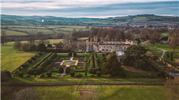
Today Sudeley Castle remains the only private castle in England to have a queen buried within the grounds - Queen Katherine Parr, the last and surviving wife of King Henry VIII – who lived and died in the castle.

Henry himself, Anne Boleyn, Lady Jane Grey, Queen Elizabeth I and Richard III have all played a part in Sudeley’s story. King Charles I found refuge here during the Civil War, when his nephew Prince Rupert established headquarters at the Castle. Following its ‘slighting’ on Cromwell’s orders at the end of the Civil War, Sudeley lay neglected and derelict for nearly 200 years.

Then in 1837, Sudeley was rescued by the wealthy Worcester glove-makers, brothers John and William Dent, who began an ambitious restoration programme, which was continued by their nephew, John Coucher Dent, when he inherited the castle in 1855. His wife, Emma Brocklehurst, threw herself enthusiastically into Sudeley’s restoration, at the same time forging strong links with the nearby town of Winchcombe. It is the results of Emma’s dedication that are so evident in the gardens and exhibitions at Sudeley today.

Sudeley Castle & Gardens is now the home of Elizabeth, Lady Ashcombe, and her son, daughter and their families. The family is committed to the continued preservation of the castle, its treasures and the ongoing restoration and regeneration of the gardens.

https://sudeleycastle.co.uk/

Land owner permission not required.

View and discuss this location in more detail on Grey Arrows.

Co-ordinates: 51.94735, -1.956415 • what3words: ///bogus.eyeful.provoking

The originator declared that this location was not inside a Flight Restriction Zone at the time of being flown on 22/01/2023. It remains the responsibility of any pilot to check for any changes before flying at the same location.

Where to fly your drone


Recently added locations

Dalnaglar Castle, Glen Shee (By AlbionDrones)

A stunning Baronial Castle glimpsed from the roadside.

Park up in the car park for the Clach na Coileach, and you can see the castle at about 500m away, behind some trees. Best approach would be to fly a little down the glen, then turn and fly up to the castle, with it being visible rather than being hidden by trees, but as can be seen I was chancing the mizzly weather, so wanted to keep the flight time to an absolute minimum...

Land owner permission requirements unknown.

View and discuss this location on Grey Arrows.

Co-ordinates: 56.76612, -3.398931 • what3words: ///teeth.gracing.mystified

Wakefield Cathedral (By richrab)

Wakefield Cathedral, or the Cathedral Church of All Saints in Wakefield, West Yorkshire, England, is a co-equal Anglican cathedral with Bradford and Ripon Cathedrals, in the Diocese of Leeds and a seat of the Bishop of Leeds. Originally the parish church, it has Anglo Saxon origins and, after enlargement and rebuilding, has the tallest spire in Yorkshire. Its 247-foot (75 m) spire is the tallest structure in the City of Wakefield. The cathedral was designated a Grade I listed building on 14 July 1953.

In a pedestrian zone, there is a lane and small courtyard just behind, Marked as TOAL point.

There is a RED FRZ in place but upon looking it is Helicopters only.
This area is close to the Prison FRZ so don't fly west from here.

Land owner permission not required.

View and discuss this location on Grey Arrows.

Co-ordinates: 53.68299, -1.496811 • what3words: ///guard.weep.rider

Tregoad Holiday Park (By lurch003)

Great place to stay, surrounded by fields and forests, and a great vantage point if you're brave enough to fly towards Looe Island

Land owner permission not required.

View and discuss this location on Grey Arrows.

Co-ordinates: 50.37805, -4.432871 • what3words: ///sectors.tunnel.fruits

Flagstaff Quarry, and The Hoveringham II shipwreck (By Banjonic)

We parked at Penmon Priory and asked the guy in the toll shed if we can get access to the quarry. He gave us the padlock code for the gate so we didn’t have to climb over it. An easy walk across some fields.
There is a ship wreck called the Hoveringham II off the bay which we wanted to get closer to from the quarry.

Land owner permission obtained.

View and discuss this location on Grey Arrows.

Co-ordinates: 53.30466, -4.049213 • what3words: ///waxer.country.takeovers

Kinlochleven overlooking Loch (By Airlessmean)

on the final push of my walk ii had this beautiful view!

Land owner permission not required.

View and discuss this location on Grey Arrows.

Co-ordinates: 56.71656, -4.962602 • what3words: ///digestion.tailing.stewing

Kings house Hotel (By Airlessmean)

bit of kings house in the morning :) nice clouds over the mountain making an awesome atmosphere!

Land owner permission not required.

View and discuss this location on Grey Arrows.

Co-ordinates: 56.652, -4.8401 • what3words: ///accordion.agency.webcams

Bridge of orchy (By Airlessmean)

was a stunning view !

Land owner permission not required.

View and discuss this location on Grey Arrows.

Co-ordinates: 56.51809, -4.770609 • what3words: ///breakaway.pairings.create

island I VOW (By Airlessmean)

passing rowardenan and ivernaid hotel i stopped at a point and captured this stunning little island in the water on the loch lomond

Land owner permission not required.

View and discuss this location on Grey Arrows.

Co-ordinates: 56.27769, -4.696804 • what3words: ///obstruct.vocal.oath

Spud Wood (By AlbionDrones)

Spud Woods in Lymm, park in the free car park, short walk over Grantham's Bridge - over the Bridegwater Canal - and then lots of options as to where to fly.

For a drone meet up turn right and follow the path to the meadow with the picnic bench and 2 other benches and its a nice open field to fly over alongside the woodland and canal - for the adventurous there are the woodland paths to fly through...

Walk straight ahead to the central clering, about 60m wide and about 1/4 mile long, bending left, sheltered between the trees..

Turn left and another much smaller meadow alongside the canal.

Easliy accessible with a shorter walk than Beacon Fell on what appears to be good solid ground.

A good few families walking, and dot walkers, but no-one had issue with the drones being flown, there are no 'no drone' signs, and nothing online I can find - owned by the Woodland Trust, who don't seem to have a drone policy on their website...

Land owner permission requirements unknown.

View and discuss this location on Grey Arrows.

Co-ordinates: 53.38314, -2.448541 • what3words: ///launched.showdown.redouble

Danraven Cliffs (By 20Five)

Dunraven is a great place to visit with the family. Beach, ice cream, castle grounds, woods and cliffside walks.

Parking is currently £5 cash for all day parking. If the main car park is full, which it will be, the warden will guide you to the overflow field which has plenty of spaces.

Wikipedia:
The cliffs are mostly formed of blue lias, a sequence of carboniferous limestone layers from the Triassic period, folded and tilted in places but otherwise level, while Witches Point is composed of Sutton Stone, a lighter-colored limestone which overlays the blue lias and represents an unconformity, with a gap between the two strata of around 150 million years.

Land owner permission not required.

View and discuss this location on Grey Arrows.

Co-ordinates: 51.44084, -3.596313 • what3words: ///treat.sisters.dizziness


Show All Locations

Service provided by