|
 Parking & TOAL: 51.869025, -2.745608 Parking & TOAL: 51.869025, -2.745608
The first thing to be borne in mind about Pembridge castle is that it is thirty miles south of Pembridge village. The reason for this is that both places share a family name. The village of Pembridge between Kington and Leominster gave its name to an Anglo-Norman family. They in turn gave their name to the second Pembridge castle at Welsh Newton by Monmouth. It should be remembered that the second Pembridge castle is a better description of the castle at Welsh Newton as there is a first Pembridge castle within the village of Pembridge itself. The purpose of the article which follows is to chronicle the history of the Pembridge family and unravel the history of Pembridge castle.
It is not certain when the manor of Pembridge came into the hands of the family that was to bear its name. In Domesday the manor (Penebruge) was held by Alfred Marlborough, the lord of Ewias Harold. Here it was noted that the land had been held by Earl Harold before Domesday at a value of £16, and according to the canons of St Guthlac's he and his father, Earl Godwine, had seized it illegally from them. The land had been waste in 1066 and was now worth £10 10s. Interestingly the land was measured as being of eleven hides minus one virgate. The question is why is one virgate missing from the productive land that the Domesday surveyors were looking for? It has been suggested elsewhere that castles were ignored in the survey simply because they were drains on local resources, rather than sources of revenue. If this is the case at Pembridge it may well suggest that the castle was already in existence in this border area. It would therefore seem likely that Ralph Pembridge (1075-1103+) was the first member of that family name to be granted the town by William Braose of Bramber (1073-c.1094). William apparently became lord of Radnor, some time soon after the Domesday survey. Some time in the period 1119 to 1139 and probably between 10 July 1137 and April 1138, it was noted that all the estates of Alfred Marlborough were in the hands of Miles Gloucester (c.1119-43) except for Pembridge. This was elsewhere noted as being held by William Braose.
Ralph Pembridge was one the leading men of the district who witnessed a grant of Philip Braose at Radnor, probably in the period 1094 to 1120, soon after the death of William Braose about 1094. By 1203 his descendant, Henry Pembridge, held five knights' fees in Herefordshire, which almost certainly included Pembridge. Henry died in 1211 and Ralph Pembridge fined with king John for 100 marks and one good horse to enjoy possession of his father's lands. Of this amount he immediately paid 25 marks into the Treasury. Ralph may well have been dead by 22 November 1221 when first mention is made of another Henry Pembridge who had certainly inherited Pembridge by 1230 when his overlord, William Braose, was executed by Llywelyn ab Iorwerth. The lordship of Radnor was subsequently passed into the custody of Ralph Mortimer of Wigmore (1211-1246) who married one of the Braose heiress's to his own eldest son Roger Mortimer of Wigmore (1232-82). In 1242 Henry Pembridge was noted as holding Pembridge and the adjacent vills for one knight's fee of the honour of Radnor, then in the custody of Ralph Mortimer.
By 1249 it was noted that Henry Pembridge held Burton of Roger Mortimer's land of Radnor and soon after Henry was made escheator of Worcestershire, an office in which he was replaced on 4 May 1251 by Simon Ribbesford, another Mortimer tenant. Around this time Henry appears to have married Elizabeth Gamages, and through her inherited the lordships and castles of Boughrood and Trewern in Elfael. In 1255 Henry was made sheriff of Hereford, and pursued his new office with great diligence, and consequently tripling the paperwork being kept at the Exchequer. At the start of the first Welsh War of Llywelyn ap Gruffydd in 1256 Henry Pembridge and his overlord Roger Mortimer of Wigmore, appear to have acted in unison for on 28 June 1258 a commission of oyer and terminer was given to Gilbert Talbot and Robert Turbeville touching trespasses and excesses committed against Roger Mortimer and Henry Pembridge in the parts of Wales, by Roger Tony, Richard Thunderley and Alan the constable of Painscastle. No doubt this concerned the manors of Boughrood and Trewern, which Henry therefore appears to have been holding as a member of the lordship of Radnor. On 23 February 1259 Henry was ordered to send 100 marks, from where he was serving with the army of Monmouth, to Roger Mortimer as part payment of his debt to the Crown, in order that Roger could continue his war against the Welsh. Roger's war took a decided turn for the worse in November 1262 when he, with Humphrey Bohun, was defeated at Cefnllys by Llywelyn ap Gruffydd. As a consequence on 24 December the king ordered Henry Pembridge and others to defend the Marches, and soon afterwards Henry Pembridge in particular was ordered to defend 'his castle in the Marches'. Whether this castle was one at Pembridge, Pembridge Castle at Welsh Newton, Boughrood or Trewern is unknown, but one would suspect that Boughrood is meant, although all these regions were then directly threatened by Llywelyn.
That Henry Pembridge was ordered to defend one of his castles suggests that he had already taken the baronial side in the brewing conflict that was to be called the Barons' War. This impression is strengthened on 6 March 1264 when Henry Pembridge and other Marchers were ordered to stop Llywelyn, who was attacking the king's men in the Marches. Those actually being attacked at the time were none other than Roger Mortimer and his supporters and it would appear that Henry was not supporting his overlord, if not directly moving against him at this time. Whatever the case, Henry Pembridge survived the battle of Evesham on 4 August 1265 and was at the council of Westminster in September. Here he insulted Prince Edmund and, enraged, set fire to Warwick before being captured by the royalists. Henry was then given into the charge of Roger Mortimer, who had his own grudges to settle. Henry and his family were incarcerated at Wigmore castle and his estates forfeited to his overlord of Radnor. Roger then forced him to make a formal conveyance of Pembridge to him and ratify this before the court of the county at Hereford. Then, holding his sons hostage, Roger took him to Clarendon where he acknowledged his quit-claim before the king. Four instruments recording this are still preserved in the Mortimer cartulary, and well show Roger's determination to gain the rich land of Pembridge. On 16 November 1265 the king ordered the restoration to Henry of all the lands he had lost to the king's enemies. As Roger Mortimer had never been the king's enemy this did not include Pembridge and Henry Pembridge Junior failed in his 1267 attempt to regain the vill, and with this the Pembridge family appear to have accepted the loss, with Pembridge from now on being a demesne land of the lordship of Radnor. They remained however, lords of Pembridge castle by Welsh Newton until the death of Richard Pembridge in 1346.
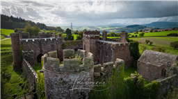
The current ruins of Pembridge castle were founded before 1208 by Matilda St Valery, the Amazonian wife of William Braose (d.1211). The western front of the castle consists of a fine three storey round keep standing in a corner between a great hall and solar block and a much rebuilt twin-towered gatehouse. Although the towers here are unequal there are other gatehouses like this throughout the British Isles. Various English examples survive at Beeston, Bungay, Clifford, Dover, Longtown, St Briavels, the Tower of London and Whittington. In Wales they exist at Caerphilly, Carmarthen, Chepstow, Criccieth, Degannwy, Dinas Bran, Llanstephan, Llawhaden, Oystermouth, Powis, Rhuddlan, Tinboeth and White Castle. In Scotland they can be found at Kildrummy and Urquhart and finally elsewhere in Ireland at Carrickfergus, Castle Roche, Limerick and Roscommon.
The eastern front boasts the castle chapel and two unique turrets. Much of the castle still stands to battlement height, although much Victorian rebuilding has taken place. The castle is now a private house, rarely open to the public.
https://en.wikipedia.org/wiki/Pembridge_Castle
Land owner permission not required.
View and discuss this location in more detail on Grey Arrows.
Co-ordinates: 51.8698, -2.744954 • what3words: ///biggest.compiler.observer
|