Where can I fly my drone in the UK and get £5,000,000 Public Liability Insurance cover? Welcome to Drone Scene!

Wondering where you can legally fly your drone? Looking for great places to fly? Looking for £5m Public Liability Insurance cover? Well look no further!

Welcome to Drone Scene, the place to find great drone flying locations in the UK, view images and videos posted by other pilots and share your flying locations in order to help other UK hobbyists find great locations where they can fly safely too.

Click on a marker pin to view details of that location. You can also add comments and discuss the location in our forum.

×You must login to see Airspace Restrictions, National Trust boundaries and other interactive map layers.

All Saint's Church, Kemble added to Places of Worship in South West by clinkadink on 02/09/2022

Parking and TOAL next to the church on Church Lane.

NOTE: this is inside an FRZ. Permission to fly needs to be obtained from Cotswolds Airport ATC first.

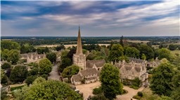
In the year 682 Cedwalla, King of Wessex, gave a grant of land in Kemble to Aldhelm, the Abbot of Malmesbury. It is certain that a church was built about that date. Present records show that a stone building was erected consisting of a nave, south aisle, chancel and western tower between 1100 and 1250. The south porch was built by William de Collerne, Abbot of Malmesbury, in 1280. The tower dates back to about 1250, thespire to about 1480 and the font to 1350. In 1823 the church and spire were severely damaged by lightning during a storm on the 29th December and was not in use for a long time. A large part of the church was rebuilt in 1872-73 and the spire restored in 1964.

The church is in the early English style except for the south chapel. The north aisle was a new addition; otherwise the original stone was used. On the south east buttresses are four 13th century coffin lids with crosses, used to patch the tower. The early English south porch with an image niche above the doorway of keeled roll moulding is worthy of notice.

The south chapel, which is reputed to have been built from the stone of a church at Ewen, has a fine moulded trefoil sedila and piscine, a tomb recess of 1320, and three perpendicular windows. The organ and ease, dated 1788, is almost unique. Only two of its kind were ever built. It was given in memory of the late SJ.Phillips, and is in this chapel, which has been furnished with an altar and chairs by Mr W.S.Boycott in memory of members of his family.

The pulpit was installed at the 1872 restoration, and the very handsome lectern about 1900. The plain octagonal font on a modern base is 14th century. Note the Hanoverian Coat-of-Arms over the doorway.

The monuments of an effigy of a knight,1290, in Purbeck marble, and of Elizabeth Coxe, 1783, Ann Coxe,1790, and Charles Coxe,1808, are fine examples of the period.

The Church yard was closed at the end of the last century and contains some old vaults. The great Yew tree is generally considered to date from Anglo Saxon times: a more recent legend says that Roundheads tied their horses to it in the Civil War. It contains a new tree growing in the trunk of the old one, and experts have given assurance that the tree will live for many years.

Land owner permission requirements unknown.

View and discuss this location in more detail on Grey Arrows.

Co-ordinates: 51.67167, -2.016924 • what3words: ///fans.spearing.camera

The originator declared that this location was inside a flight restriction zone at the time of being flown. Permission to fly was obtained from Cotswold Airport ATC. It remains the responsibility of any pilot to check for any changes before flying at the same location.

Where to fly your drone


Recently added locations

Tregoad Holiday Park (By lurch003)

Great place to stay, surrounded by fields and forests, and a great vantage point if you're brave enough to fly towards Looe Island

Land owner permission not required.

View and discuss this location on Grey Arrows.

Co-ordinates: 50.37805, -4.432871 • what3words: ///sectors.tunnel.fruits

Flagstaff Quarry, and The Hoveringham II shipwreck (By Banjonic)

We parked at Penmon Priory and asked the guy in the toll shed if we can get access to the quarry. He gave us the padlock code for the gate so we didn’t have to climb over it. An easy walk across some fields.
There is a ship wreck called the Hoveringham II off the bay which we wanted to get closer to from the quarry.

Land owner permission obtained.

View and discuss this location on Grey Arrows.

Co-ordinates: 53.30466, -4.049213 • what3words: ///waxer.country.takeovers

Kinlochleven overlooking Loch (By Airlessmean)

on the final push of my walk ii had this beautiful view!

Land owner permission not required.

View and discuss this location on Grey Arrows.

Co-ordinates: 56.71656, -4.962602 • what3words: ///digestion.tailing.stewing

Kings house Hotel (By Airlessmean)

bit of kings house in the morning :) nice clouds over the mountain making an awesome atmosphere!

Land owner permission not required.

View and discuss this location on Grey Arrows.

Co-ordinates: 56.652, -4.8401 • what3words: ///accordion.agency.webcams

Bridge of orchy (By Airlessmean)

was a stunning view !

Land owner permission not required.

View and discuss this location on Grey Arrows.

Co-ordinates: 56.51809, -4.770609 • what3words: ///breakaway.pairings.create

island I VOW (By Airlessmean)

passing rowardenan and ivernaid hotel i stopped at a point and captured this stunning little island in the water on the loch lomond

Land owner permission not required.

View and discuss this location on Grey Arrows.

Co-ordinates: 56.27769, -4.696804 • what3words: ///obstruct.vocal.oath

Spud Wood (By AlbionDrones)

Spud Woods in Lymm, park in the free car park, short walk over Grantham's Bridge - over the Bridegwater Canal - and then lots of options as to where to fly.

For a drone meet up turn right and follow the path to the meadow with the picnic bench and 2 other benches and its a nice open field to fly over alongside the woodland and canal - for the adventurous there are the woodland paths to fly through...

Walk straight ahead to the central clering, about 60m wide and about 1/4 mile long, bending left, sheltered between the trees..

Turn left and another much smaller meadow alongside the canal.

Easliy accessible with a shorter walk than Beacon Fell on what appears to be good solid ground.

A good few families walking, and dot walkers, but no-one had issue with the drones being flown, there are no 'no drone' signs, and nothing online I can find - owned by the Woodland Trust, who don't seem to have a drone policy on their website...

Land owner permission requirements unknown.

View and discuss this location on Grey Arrows.

Co-ordinates: 53.38314, -2.448541 • what3words: ///launched.showdown.redouble

Danraven Cliffs (By 20Five)

Dunraven is a great place to visit with the family. Beach, ice cream, castle grounds, woods and cliffside walks.

Parking is currently £5 cash for all day parking. If the main car park is full, which it will be, the warden will guide you to the overflow field which has plenty of spaces.

Wikipedia:
The cliffs are mostly formed of blue lias, a sequence of carboniferous limestone layers from the Triassic period, folded and tilted in places but otherwise level, while Witches Point is composed of Sutton Stone, a lighter-colored limestone which overlays the blue lias and represents an unconformity, with a gap between the two strata of around 150 million years.

Land owner permission not required.

View and discuss this location on Grey Arrows.

Co-ordinates: 51.44084, -3.596313 • what3words: ///treat.sisters.dizziness

Heights of Abraham Matlock (By Woody305)

The Heights of Abraham is a tourist attraction in Derbyshire.

It consists of a hilltop park on top of Masson Hill, accessed from the village by the Heights of Abraham cable car. The heights are named after a supposed resemblance to the Plains of Abraham, also known as the Heights of Abraham, in Quebec, Canada, where James Wolfe died in battle.

Amongst the attractions in the park, which has been open since Victorian times, are cavern and mine tours. There are also views of the dramatic scenery of the valley of the River Derwent. The cable car was opened in 1984 to provide easier access.

The Heights of Abraham are listed as grade II in the register of historic parks and gardens of special historic interest in England.

Land owner permission not required.

View and discuss this location on Grey Arrows.

Co-ordinates: 53.124, -1.554791 • what3words: ///kind.baseballs.activity

St James Church, Coventry (By BudgieUK)

This is a local parish church. The surrounding roads are quite quiet, and parking around the area is easy.

Land owner permission requirements unknown.

View and discuss this location on Grey Arrows.

Co-ordinates: 52.38885, -1.515566 • what3words: ///give.clock.pines


Show All Locations

Service provided by