Where can I fly my drone in the UK and get £5,000,000 Public Liability Insurance cover? Welcome to Drone Scene!

Wondering where you can legally fly your drone? Looking for great places to fly? Looking for £5m Public Liability Insurance cover? Well look no further!

Welcome to Drone Scene, the place to find great drone flying locations in the UK, view images and videos posted by other pilots and share your flying locations in order to help other UK hobbyists find great locations where they can fly safely too.

Click on a marker pin to view details of that location. You can also add comments and discuss the location in our forum.

×You must login to see Airspace Restrictions, National Trust boundaries and other interactive map layers.

St Andrews Church, Weston added to Places of Worship in West Midlands by D0c.Col on 24/12/2022

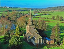
Grade II* Parish church of C13, restored in 1825, 1860 by G.G. Scott and 1872 by Butterfield.

MATERIALS: Ashlar with tooled C19 masonry to the chancel, tile roofs, except for copper roof of south aisle.

PLAN: Aisled nave and chancel, west tower, south porch and north-east vestry.

EXTERIOR: The broad 2-stage early C13 tower has moulded strings, massive clasping buttresses and internal south-west turret. The large lancet west window has a double-chamfered surround, with smaller lancets on north and south sides. Tripartite arcading in the upper stage has blind outer arches, and inner arches subdivided and with louvres. The parapet and octagonal stone spire with lucarnes were added in the 1830s. The remainder of the exterior is almost entirely C19. The nave has 3-bay aisles under lean-to roofs, with 2-light and 3-light Decorated windows, and paired and triple clerestorey windows with trefoil heads. The tall buttressed porch has re-used C13 trefoil-headed entrance, and nave doorway with nook shafts. The re-faced chancel has aisles under lean-to roofs, with re-used 2-light Decorated windows and blind south doorway. The east wall has triple lancets separated by deep buttresses, with a small quatrefoil window in the gable. The gabled north-east vestry has diagonal buttresses.

HISTORY: The west tower is early C13 and the arcades and chancel arch only slightly later. Chancel arcades appear to date from the erection of aisles in 1825, although it has been argued that the piers are C13 but altered in the C19. The chancel was re-faced and re-roofed in the 1840s. The original nave north aisle was taken down in 1685, but the arcade was preserved. A new aisle had been built in 1825 but it was replaced in 1860 by George Gilbert Scott (1811-78). The south aisle was rebuilt and widened in 1872 by William Butterfield (1829-99), who also heightened the nave by adding a clerestorey, with trademark polychrome interior decoration, adding a north vestry and rebuilding the porch using old masonry.

TOAL was from the Church Carpark, which is also open for parking.

Land owner permission not required.

View and discuss this location in more detail on Grey Arrows.

Co-ordinates: 52.84127, -2.039316 • what3words: ///open.intruded.irrigated

The originator declared that this location was not inside a Flight Restriction Zone at the time of being flown on 24/12/2022. It remains the responsibility of any pilot to check for any changes before flying at the same location.

Where to fly your drone


Recently added locations

Drakeholes (By Woody305)

The Duck At Drakeholes. Lovely spot to see Narrow Boats on the Chesterfield Canal and have a cool drink or a bite to eat. TOAL was parked up at side of Wiseton Road.Clear LOS

Land owner permission not required.

View and discuss this location on Grey Arrows.

Co-ordinates: 53.40559, -0.938813 • what3words: ///helpers.pots.supposing

Denbigh Asylum Ruins (By Dren)

Flew here today after much research, no actual access to site as is actively protected by security guards hiding in building wearing kharki, combat clothing was reported on other sites this their attitude to combat trespass. My drone did draw two guards out of cover whilst hovering above incredible old building in poor disrepute.

Land owner permission requirements unknown.

View and discuss this location on Grey Arrows.

Co-ordinates: 53.17417, -3.421029 • what3words: ///hippy.divided.hillsides

Gamelands stone circle (By markas)

Gamelands stone circle lies between the village of Orton and the hamlet of Raisbeck. It is an oval enclosure of around 40 large stones, all of which have fallen, together with three smaller stones. The stones are set into a slight bank. All of the stones are of pink granite with the exception of one which is limestone. The stones are all below one metre in height and are arranged in an oval of 42 metres by 35 metres.

Land owner permission requirements unknown.

View and discuss this location on Grey Arrows.

Co-ordinates: 54.46751, -2.556853 • what3words: ///bonkers.ghosts.opposing

Teignmouth (By richrab)

Teignmouth is a seaside town, fishing port and civil parish in the English county of Devon. It is on the north bank of the estuary mouth of the River Teign, about 12 miles (19 km) south of Exeter.

Parked Car and TOAL from the Ness Car park.

Land owner permission not required.

View and discuss this location on Grey Arrows.

Co-ordinates: 50.53737, -3.499931 • what3words: ///emporium.screeches.breathing

Paignton - Devon (By richrab)

Paignton is a seaside town on the coast of Tor Bay in Devon, England. Together with Torquay and Brixham it forms the borough of Torbay which was created in 1968. The Torbay area is a holiday destination known as the English Riviera.

TOAL from a Bench on the promenade.
Last week in March so not many people about.

Land owner permission not required.

View and discuss this location on Grey Arrows.

Co-ordinates: 50.43277, -3.558799 • what3words: ///among.keeps.brass

Dartmouth - Devon (By richrab)

Dartmouth is a town and civil parish in the English county of Devon. It is a tourist destination set on the western bank of the estuary of the River Dart, which is a long narrow tidal ria that runs inland as far as Totnes. It lies within the South Devon Area of Outstanding Natural Beauty.

TOAL and Parking was on Higher Contour Road. ///roofed.clenching.glider

Land owner permission not required.

View and discuss this location on Grey Arrows.

Co-ordinates: 50.3489, -3.568722 • what3words: ///sings.rezoning.fists

Loch Dunmore, Faskally Forest, Perthshire (By AlbionDrones)

Park up at the Forestry Commission car park - there is a charge, but also toilets - and walk the short distance to the loch to find a spot for TOAL, we chose the path near the bridge and flew from there.

It can get busy at certain times of day and year, especially when the Fantasy Forest is on in the Autumn, but definitely worth a stop, the reflections are awesome in the sheltered and still water...

Land owner permission requirements unknown.

View and discuss this location on Grey Arrows.

Co-ordinates: 56.71111, -3.765409 • what3words: ///galloped.pouch.store

Blagdon Lake (By richrab)

Blagdon Lake lies in a valley at the northern edge of the Mendip Hills, close to the village of Blagdon and approximately 10 miles (16 km) south of Bristol, England. The lake was created by Bristol Water (Bristol Waterworks Company as it was known then), when it dammed the River Yeo, starting construction in 1898, to designs by Charles Hawksley, and completing this in 1905. The Wrington Vale Light Railway was constructed primarily to bring building materials for the lake.

On the edge of SSI, plenty of birds around the lake, so one to be mindful of.

Land owner permission not required.

View and discuss this location on Grey Arrows.

Co-ordinates: 51.33576, -2.706242 • what3words: ///promoting.throw.cowboys

Burrington Combe (By richrab)

Burrington Combe is a Carboniferous Limestone gorge near the village of Burrington, on the north side of the Mendip Hills Area of Outstanding Natural Beauty, in North Somerset, England.
According to legend Augustus Montague Toplady was inspired to write the hymn Rock of Ages while sheltering under a rock in the combe, although recent scholars have disputed this claim.

The Cobme is in a Amber zone for Scientific or Nature interest.
There is a herd of goats living wild among the rocks.

Land owner permission not required.

View and discuss this location on Grey Arrows.

Co-ordinates: 51.32418, -2.752609 • what3words: ///think.fire.producing

Barrow Tanks (By richrab)

Barrow Gurney Reservoirs (grid reference ST5468) (also known as Barrow Gurney Tanks or Barrow Tanks) are three artificial reservoirs for drinking water near the village of Barrow Gurney, which lies southwest of Bristol, England. They are known by their numbers rather than names.

They are fed by several springs including one which becomes the Land Yeo. Some of the outfall is also used to feed the river which flows to the Bristol Channel.

The Tanks are right on the border of Bristol airport no fly zone.
Parking on the A38 is not practical so TOAL was Dundry Lane.

Land owner permission not required.

View and discuss this location on Grey Arrows.

Co-ordinates: 51.40883, -2.659324 • what3words: ///left.grant.pest


Show All Locations

Service provided by