Where can I fly my drone in the UK and get £5,000,000 Public Liability Insurance cover? Welcome to Drone Scene!

Wondering where you can legally fly your drone? Looking for great places to fly? Looking for £5m Public Liability Insurance cover? Well look no further!

Welcome to Drone Scene, the place to find great drone flying locations in the UK, view images and videos posted by other pilots and share your flying locations in order to help other UK hobbyists find great locations where they can fly safely too.

Click on a marker pin to view details of that location. You can also add comments and discuss the location in our forum.

×You must login to see Airspace Restrictions, National Trust boundaries and other interactive map layers.

New Wardour Castle added to Historic Buildings in South West by clinkadink on 27/02/2023

Parking & TOAL: 51.038724, -2.090382

There is free parking to the north of the old castle, but this is with the English Heritage boundary. So I TOAL'd from a passing place in the lane north of the old castle. The new castle (historic building) is approximately 1km northwest of the lane in clear view, but is on private ground.

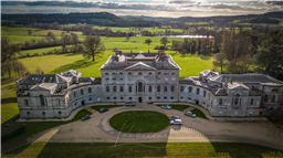
New Wardour Castle is a Grade I listed English country house at Wardour, near Tisbury in Wiltshire, built for the Arundell family. The house is of Palladian style, designed by the architect James Paine, with additions by Giacomo Quarenghi, who was a principal architect of the Imperial Russian capital city, Saint Petersburg.

The building of the house was begun in 1769 and completed in 1776, with additional buildings being added in the 1970s and 1980s. From 1961 to 1990, it was the home of Cranborne Chase School, an independent boarding school for girls.

New Wardour Castle is approximately 0.75 miles (1.2 km) from Old Wardour Castle, which was left as a landscape feature of the parkland of the new house. This was formerly the home of the Arundell family before it was besieged, damaged and slighted in the Civil War.

After the death in 1944 of John Francis, 16th and last Lord Arundell of Wardour, the building was leased. It was designated in 1951 by Historic England as a Grade I listed building, with its grounds later being Grade II* listed.

In 1946 the property was acquired by the Society of Jesus, who in 1955 licensed it to the Leonard Cheshire Foundation for a trial period. The initial idea of the founder, Group Captain Leonard Cheshire, was to use it as a home for rehabilitating prisoners, but in the event it became a home for those who could not be accepted into other Cheshire Homes in the UK. The home officially opened in January 1956 under warden Colonel Ervine Andrews who used part of the grounds as a pig farm to support the home financially. The number of residents was limited to eight since the charity could only renovate part of the building for the residents to live in; the rest of the property was in poor structural condition. Despite an offer from the Ministry of Works of £40,000 to renovate the property, the trustees of the Leonard Cheshire Foundation could not commit to raising the further £20,000 needed to get the work done. The home closed on 1 January 1957, and the five remaining residents moved out.

In 1961 it became the home of Cranborne Chase School. The school built new classrooms, studio dormitories and a dining-room extension on the south-eastern side of the main house, along with three staff houses to the west. The school eventually closed in 1990.

In 1992 the house – along with five cottages, six tennis courts, and a swimming pool in the walled garden – was sold for under £1 million to Nigel Tuersley, and was converted into 10 apartments by designer John Pawson. The two main floors of the central block, incorporating the rotunda and the original state rooms, form the principal apartment. It has eight reception rooms arranged in a circle around a piano nobile at the top of a 60ft rotunda that rises to a magnificent glazed dome supported by eight composite columns. Conran called the staircase "possibly the best staircase in England, if not the world". Extensions and ancillary accommodation added by the school were mostly demolished.

The house was used in the filming of the television mini-series First Born (1988), and in the filming of Billy Elliot, a film released in 2000.

https://view.digital-hub.global/wardour-castle/p/2

Land owner permission not required.

View and discuss this location in more detail on Grey Arrows.

Co-ordinates: 51.04172, -2.104301 • what3words: ///weary.gosh.grub

The originator declared that this location was not inside a Flight Restriction Zone at the time of being flown on 26/02/2023. It remains the responsibility of any pilot to check for any changes before flying at the same location.

Where to fly your drone


Recently added locations

Drakeholes (By Woody305)

The Duck At Drakeholes. Lovely spot to see Narrow Boats on the Chesterfield Canal and have a cool drink or a bite to eat. TOAL was parked up at side of Wiseton Road.Clear LOS

Land owner permission not required.

View and discuss this location on Grey Arrows.

Co-ordinates: 53.40559, -0.938813 • what3words: ///helpers.pots.supposing

Denbigh Asylum Ruins (By Dren)

Flew here today after much research, no actual access to site as is actively protected by security guards hiding in building wearing kharki, combat clothing was reported on other sites this their attitude to combat trespass. My drone did draw two guards out of cover whilst hovering above incredible old building in poor disrepute.

Land owner permission requirements unknown.

View and discuss this location on Grey Arrows.

Co-ordinates: 53.17417, -3.421029 • what3words: ///hippy.divided.hillsides

Gamelands stone circle (By markas)

Gamelands stone circle lies between the village of Orton and the hamlet of Raisbeck. It is an oval enclosure of around 40 large stones, all of which have fallen, together with three smaller stones. The stones are set into a slight bank. All of the stones are of pink granite with the exception of one which is limestone. The stones are all below one metre in height and are arranged in an oval of 42 metres by 35 metres.

Land owner permission requirements unknown.

View and discuss this location on Grey Arrows.

Co-ordinates: 54.46751, -2.556853 • what3words: ///bonkers.ghosts.opposing

Teignmouth (By richrab)

Teignmouth is a seaside town, fishing port and civil parish in the English county of Devon. It is on the north bank of the estuary mouth of the River Teign, about 12 miles (19 km) south of Exeter.

Parked Car and TOAL from the Ness Car park.

Land owner permission not required.

View and discuss this location on Grey Arrows.

Co-ordinates: 50.53737, -3.499931 • what3words: ///emporium.screeches.breathing

Paignton - Devon (By richrab)

Paignton is a seaside town on the coast of Tor Bay in Devon, England. Together with Torquay and Brixham it forms the borough of Torbay which was created in 1968. The Torbay area is a holiday destination known as the English Riviera.

TOAL from a Bench on the promenade.
Last week in March so not many people about.

Land owner permission not required.

View and discuss this location on Grey Arrows.

Co-ordinates: 50.43277, -3.558799 • what3words: ///among.keeps.brass

Dartmouth - Devon (By richrab)

Dartmouth is a town and civil parish in the English county of Devon. It is a tourist destination set on the western bank of the estuary of the River Dart, which is a long narrow tidal ria that runs inland as far as Totnes. It lies within the South Devon Area of Outstanding Natural Beauty.

TOAL and Parking was on Higher Contour Road. ///roofed.clenching.glider

Land owner permission not required.

View and discuss this location on Grey Arrows.

Co-ordinates: 50.3489, -3.568722 • what3words: ///sings.rezoning.fists

Loch Dunmore, Faskally Forest, Perthshire (By AlbionDrones)

Park up at the Forestry Commission car park - there is a charge, but also toilets - and walk the short distance to the loch to find a spot for TOAL, we chose the path near the bridge and flew from there.

It can get busy at certain times of day and year, especially when the Fantasy Forest is on in the Autumn, but definitely worth a stop, the reflections are awesome in the sheltered and still water...

Land owner permission requirements unknown.

View and discuss this location on Grey Arrows.

Co-ordinates: 56.71111, -3.765409 • what3words: ///galloped.pouch.store

Blagdon Lake (By richrab)

Blagdon Lake lies in a valley at the northern edge of the Mendip Hills, close to the village of Blagdon and approximately 10 miles (16 km) south of Bristol, England. The lake was created by Bristol Water (Bristol Waterworks Company as it was known then), when it dammed the River Yeo, starting construction in 1898, to designs by Charles Hawksley, and completing this in 1905. The Wrington Vale Light Railway was constructed primarily to bring building materials for the lake.

On the edge of SSI, plenty of birds around the lake, so one to be mindful of.

Land owner permission not required.

View and discuss this location on Grey Arrows.

Co-ordinates: 51.33576, -2.706242 • what3words: ///promoting.throw.cowboys

Burrington Combe (By richrab)

Burrington Combe is a Carboniferous Limestone gorge near the village of Burrington, on the north side of the Mendip Hills Area of Outstanding Natural Beauty, in North Somerset, England.
According to legend Augustus Montague Toplady was inspired to write the hymn Rock of Ages while sheltering under a rock in the combe, although recent scholars have disputed this claim.

The Cobme is in a Amber zone for Scientific or Nature interest.
There is a herd of goats living wild among the rocks.

Land owner permission not required.

View and discuss this location on Grey Arrows.

Co-ordinates: 51.32418, -2.752609 • what3words: ///think.fire.producing

Barrow Tanks (By richrab)

Barrow Gurney Reservoirs (grid reference ST5468) (also known as Barrow Gurney Tanks or Barrow Tanks) are three artificial reservoirs for drinking water near the village of Barrow Gurney, which lies southwest of Bristol, England. They are known by their numbers rather than names.

They are fed by several springs including one which becomes the Land Yeo. Some of the outfall is also used to feed the river which flows to the Bristol Channel.

The Tanks are right on the border of Bristol airport no fly zone.
Parking on the A38 is not practical so TOAL was Dundry Lane.

Land owner permission not required.

View and discuss this location on Grey Arrows.

Co-ordinates: 51.40883, -2.659324 • what3words: ///left.grant.pest


Show All Locations

Service provided by