Where can I fly my drone in the UK and get £5,000,000 Public Liability Insurance cover? Welcome to Drone Scene!

Wondering where you can legally fly your drone? Looking for great places to fly? Looking for £5m Public Liability Insurance cover? Well look no further!

Welcome to Drone Scene, the place to find great drone flying locations in the UK, view images and videos posted by other pilots and share your flying locations in order to help other UK hobbyists find great locations where they can fly safely too.

Click on a marker pin to view details of that location. You can also add comments and discuss the location in our forum.

×You must login to see Airspace Restrictions, National Trust boundaries and other interactive map layers.

Haywood Junction, Great Haywood added to Rivers and Canals in West Midlands by D0c.Col on 27/11/2022

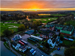
Haywood Junction, photo taken with Mini 3 Pro (my 1st picture with it!).

At Great Haywood, the Trent and Mersey Canal heads north, as it continues its ascent from Derwent Mouth towards its short summit near Stoke on Trent. Haywood Lock is just to the south, while Hoo Mill Lock is a little further to the north. The River Trent runs to the west of the canal, much too small at this point to support navigation. Derwent Mouth, where the canal joins the river, is 39 miles (63 km) from the junction, while Etruria Lock, where the summit level begins, is 18.9 miles (30.4 km) away.

The Staffordshire and Worcestershire Canal heads west from the junction. The Trent and Mersey towpath is carried over it by a bridge, and almost immediately, it crosses the River Trent on an aqueduct. It follows the valley of the River Sow, which joins the Trent below the junction, and soon reaches Tixall Wide, a broad expanse of water, which, although it looks like a lake, is deep enough to allow boats to reach its edges.

There are plenty of attractions nearby including Shugborough Park and Hall, which are now owned by the National Trust, and are located to the south, with Tixall Gatehouse to the north. The canal ascends through Tixall Lock, after which is crossed the Sow on another aqueduct. Tixall Lock is 1.3 miles (2.1 km) from the junction.

Shugborough Hall was begun in 1695, was extended in the 1760s, and some remodelling was carried out at the end of the eighteenth century by Samuel Wyatt. Internally, the plasterwork is magnificent, and the building is grade I listed. Many of the structures within the grounds are also listed. Tixall Lodge is a small octagonal-shaped building with a stone dome, which bears the date 1807. It is grade II listed, as is the roving bridge at the junction. Just to the south of Haywood Lock, a bridge carries a footpath from Great Haywood to Shugborough Hall. The path crosses the Trent at Essex Bridge, a grade I listed structure with fourteen arches, which is only 4 feet (1.2 m) wide. It was probably built in the 1500s, and is virtually unaltered. [source: wikipedia].

There is plenty of parking across the road from the junction in the Canalside Cafe & Farm shop (also featured in drone scene) during weekdays but it does get pretty busy at weekends but I've always managed to park there. They do a great breakfast as well as the normal cafe menu - all excellent!

Land owner permission not required.

View and discuss this location in more detail on Grey Arrows.

Co-ordinates: 52.80483, -2.008535 • what3words: ///iceberg.crunched.built

The originator declared that this location was not inside a Flight Restriction Zone at the time of being flown on 22/11/2022. It remains the responsibility of any pilot to check for any changes before flying at the same location.

Where to fly your drone


Recently added locations

Quarr Abbey, Isle of Wight (By KevNewton)

No permission required. TOAL available on the footpath that runs parallel to the car park. Open 24/7

Land owner permission not required.

View and discuss this location on Grey Arrows.

Co-ordinates: 50.73157, -1.205052 • what3words: ///expect.weeks.puns

Drakeholes (By Woody305)

The Duck At Drakeholes. Lovely spot to see Narrow Boats on the Chesterfield Canal and have a cool drink or a bite to eat. TOAL was parked up at side of Wiseton Road.Clear LOS

Land owner permission not required.

View and discuss this location on Grey Arrows.

Co-ordinates: 53.40559, -0.938813 • what3words: ///helpers.pots.supposing

Denbigh Asylum Ruins (By Dren)

Flew here today after much research, no actual access to site as is actively protected by security guards hiding in building wearing kharki, combat clothing was reported on other sites this their attitude to combat trespass. My drone did draw two guards out of cover whilst hovering above incredible old building in poor disrepute.

Land owner permission requirements unknown.

View and discuss this location on Grey Arrows.

Co-ordinates: 53.17417, -3.421029 • what3words: ///hippy.divided.hillsides

Gamelands stone circle (By markas)

Gamelands stone circle lies between the village of Orton and the hamlet of Raisbeck. It is an oval enclosure of around 40 large stones, all of which have fallen, together with three smaller stones. The stones are set into a slight bank. All of the stones are of pink granite with the exception of one which is limestone. The stones are all below one metre in height and are arranged in an oval of 42 metres by 35 metres.

Land owner permission requirements unknown.

View and discuss this location on Grey Arrows.

Co-ordinates: 54.46751, -2.556853 • what3words: ///bonkers.ghosts.opposing

Teignmouth (By richrab)

Teignmouth is a seaside town, fishing port and civil parish in the English county of Devon. It is on the north bank of the estuary mouth of the River Teign, about 12 miles (19 km) south of Exeter.

Parked Car and TOAL from the Ness Car park.

Land owner permission not required.

View and discuss this location on Grey Arrows.

Co-ordinates: 50.53737, -3.499931 • what3words: ///emporium.screeches.breathing

Paignton - Devon (By richrab)

Paignton is a seaside town on the coast of Tor Bay in Devon, England. Together with Torquay and Brixham it forms the borough of Torbay which was created in 1968. The Torbay area is a holiday destination known as the English Riviera.

TOAL from a Bench on the promenade.
Last week in March so not many people about.

Land owner permission not required.

View and discuss this location on Grey Arrows.

Co-ordinates: 50.43277, -3.558799 • what3words: ///among.keeps.brass

Dartmouth - Devon (By richrab)

Dartmouth is a town and civil parish in the English county of Devon. It is a tourist destination set on the western bank of the estuary of the River Dart, which is a long narrow tidal ria that runs inland as far as Totnes. It lies within the South Devon Area of Outstanding Natural Beauty.

TOAL and Parking was on Higher Contour Road. ///roofed.clenching.glider

Land owner permission not required.

View and discuss this location on Grey Arrows.

Co-ordinates: 50.3489, -3.568722 • what3words: ///sings.rezoning.fists

Loch Dunmore, Faskally Forest, Perthshire (By AlbionDrones)

Park up at the Forestry Commission car park - there is a charge, but also toilets - and walk the short distance to the loch to find a spot for TOAL, we chose the path near the bridge and flew from there.

It can get busy at certain times of day and year, especially when the Fantasy Forest is on in the Autumn, but definitely worth a stop, the reflections are awesome in the sheltered and still water...

Land owner permission requirements unknown.

View and discuss this location on Grey Arrows.

Co-ordinates: 56.71111, -3.765409 • what3words: ///galloped.pouch.store

Blagdon Lake (By richrab)

Blagdon Lake lies in a valley at the northern edge of the Mendip Hills, close to the village of Blagdon and approximately 10 miles (16 km) south of Bristol, England. The lake was created by Bristol Water (Bristol Waterworks Company as it was known then), when it dammed the River Yeo, starting construction in 1898, to designs by Charles Hawksley, and completing this in 1905. The Wrington Vale Light Railway was constructed primarily to bring building materials for the lake.

On the edge of SSI, plenty of birds around the lake, so one to be mindful of.

Land owner permission not required.

View and discuss this location on Grey Arrows.

Co-ordinates: 51.33576, -2.706242 • what3words: ///promoting.throw.cowboys

Burrington Combe (By richrab)

Burrington Combe is a Carboniferous Limestone gorge near the village of Burrington, on the north side of the Mendip Hills Area of Outstanding Natural Beauty, in North Somerset, England.
According to legend Augustus Montague Toplady was inspired to write the hymn Rock of Ages while sheltering under a rock in the combe, although recent scholars have disputed this claim.

The Cobme is in a Amber zone for Scientific or Nature interest.
There is a herd of goats living wild among the rocks.

Land owner permission not required.

View and discuss this location on Grey Arrows.

Co-ordinates: 51.32418, -2.752609 • what3words: ///think.fire.producing


Show All Locations

Service provided by