Where can I fly my drone in the UK and get £5,000,000 Public Liability Insurance cover? Welcome to Drone Scene!

Wondering where you can legally fly your drone? Looking for great places to fly? Looking for £5m Public Liability Insurance cover? Well look no further!

Welcome to Drone Scene, the place to find great drone flying locations in the UK, view images and videos posted by other pilots and share your flying locations in order to help other UK hobbyists find great locations where they can fly safely too.

Click on a marker pin to view details of that location. You can also add comments and discuss the location in our forum.

×You must login to see Airspace Restrictions, National Trust boundaries and other interactive map layers.

Basildon Park added to National Trust in South East by clinkadink on 10/09/2023

Parking & TOAL: 51.493479, -1.115587

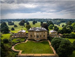
The masterpiece of John Carr of York, this Palladian villa was built for Sir Francis Sykes between 1776 and 1783. It is a beautifully balanced building of warm Bath stone consisting of a main central block joined to individual pavilions by single-storey linkages.

Sykes was the youngest son of a Yorkshire yeoman farmer who made a fortune working for the East India Company on the great Sub-Continent. He held many important posts including Factor & Chief of Kasimbazara and resided at the Court of the Nawab of Bengal, until ill-health forced him to return to England in 1768. He bought Basildon from the estate of Viscount Fane, three years later. Sykes was a close friend of Warren Hastings, the Governor-General of India, who lived at nearby Purley Hall and, along with a number of other 'nabobs' resident in the vicinity, he helped give Berkshire its reputation of being the "English Hindoostan". He was created a baronet in 1781.

Basildon was inherited by Sir Francis' grandson and namesake in 1804, when parts of the house were still incomplete. Unfortunately, Sir Francis Junior inherited massive debts from his spendthrift father and, in 1838, the estate was sold to James Morrison MP, one of the richest of the early Victorian merchant princes. He was a famous art-lover who became instrumental in the setting up of the National Gallery. He exclaimed of Basildon, "What a casket to enclose pictorial gems!". His architect, John Papworth, undertook a number of sympathetic alterations at the house between 1837 and 1842, after which the family took up full residence in the best of Victorian traditions.

The last of the Morrisons died in 1910, after which Basildon often stood empty. It was used as a convalescent home for Berkshire regimental soldiers during the Great War, but subsequently fell into an increasing state of dilapidation. The estate was purchased by the 1st Lord Iliffe in 1928 in order to expand his Yattendon lands and the house was sold on to a George Ferdinando. This man had planned to have the place systematically demolished and re-erected in the United States! A scheme which, fortunately, never came to fruition, though many of the decorative fittings can now be seen in the Waldorf Astoria Hotel.

Miraculously, in 1952, Basildon was repurchased by Lord Iliffe's son and his new bride who set about restoring the place to its present splendour. Many fixtures and fittings were bought from other country houses whose fate was not so fortunate.

https://en.wikipedia.org/wiki/Basildon_Park

Land owner permission not required.

View and discuss this location in more detail on Grey Arrows.

Co-ordinates: 51.49878, -1.121342 • what3words: ///stealthier.curated.tumble

The originator declared that this location was not inside a Flight Restriction Zone at the time of being flown on 10/09/2023. It remains the responsibility of any pilot to check for any changes before flying at the same location.

Where to fly your drone


Recently added locations

Waterwynch Bay / Brownslade Bay (By DaveJaVu)

There is room for parking for a couple of cars at the top of Waterwynch Lane. The driveway itself is a public footpath but is NOT open to vehicles. It is just under a 1km walk to the beach from the main road. Alternatively park on The Croft in Tenby itself, there is a footpath down to the beach and again it's about 1km along the beach to Waterwych Bay. It is fully accessible at medium / low tide. It is *completely* cut off at high tide so do keep a close eye on tide times!

Fantastic spot with miles of beaches, 300ft tall cliffs, and a few caves too! 🤩

Land owner permission not required.

View and discuss this location on Grey Arrows.

Co-ordinates: 51.68632, -4.695196 • what3words: ///inclines.sniff.prestige

Quarr Abbey, Isle of Wight (By KevNewton)

No permission required. TOAL available on the footpath that runs parallel to the car park. Open 24/7

Land owner permission not required.

View and discuss this location on Grey Arrows.

Co-ordinates: 50.73157, -1.205052 • what3words: ///expect.weeks.puns

Drakeholes (By Woody305)

The Duck At Drakeholes. Lovely spot to see Narrow Boats on the Chesterfield Canal and have a cool drink or a bite to eat. TOAL was parked up at side of Wiseton Road.Clear LOS

Land owner permission not required.

View and discuss this location on Grey Arrows.

Co-ordinates: 53.40559, -0.938813 • what3words: ///helpers.pots.supposing

Denbigh Asylum Ruins (By Dren)

Flew here today after much research, no actual access to site as is actively protected by security guards hiding in building wearing kharki, combat clothing was reported on other sites this their attitude to combat trespass. My drone did draw two guards out of cover whilst hovering above incredible old building in poor disrepute.

Land owner permission requirements unknown.

View and discuss this location on Grey Arrows.

Co-ordinates: 53.17417, -3.421029 • what3words: ///hippy.divided.hillsides

Gamelands stone circle (By markas)

Gamelands stone circle lies between the village of Orton and the hamlet of Raisbeck. It is an oval enclosure of around 40 large stones, all of which have fallen, together with three smaller stones. The stones are set into a slight bank. All of the stones are of pink granite with the exception of one which is limestone. The stones are all below one metre in height and are arranged in an oval of 42 metres by 35 metres.

Land owner permission requirements unknown.

View and discuss this location on Grey Arrows.

Co-ordinates: 54.46751, -2.556853 • what3words: ///bonkers.ghosts.opposing

Teignmouth (By richrab)

Teignmouth is a seaside town, fishing port and civil parish in the English county of Devon. It is on the north bank of the estuary mouth of the River Teign, about 12 miles (19 km) south of Exeter.

Parked Car and TOAL from the Ness Car park.

Land owner permission not required.

View and discuss this location on Grey Arrows.

Co-ordinates: 50.53737, -3.499931 • what3words: ///emporium.screeches.breathing

Paignton - Devon (By richrab)

Paignton is a seaside town on the coast of Tor Bay in Devon, England. Together with Torquay and Brixham it forms the borough of Torbay which was created in 1968. The Torbay area is a holiday destination known as the English Riviera.

TOAL from a Bench on the promenade.
Last week in March so not many people about.

Land owner permission not required.

View and discuss this location on Grey Arrows.

Co-ordinates: 50.43277, -3.558799 • what3words: ///among.keeps.brass

Dartmouth - Devon (By richrab)

Dartmouth is a town and civil parish in the English county of Devon. It is a tourist destination set on the western bank of the estuary of the River Dart, which is a long narrow tidal ria that runs inland as far as Totnes. It lies within the South Devon Area of Outstanding Natural Beauty.

TOAL and Parking was on Higher Contour Road. ///roofed.clenching.glider

Land owner permission not required.

View and discuss this location on Grey Arrows.

Co-ordinates: 50.3489, -3.568722 • what3words: ///sings.rezoning.fists

Loch Dunmore, Faskally Forest, Perthshire (By AlbionDrones)

Park up at the Forestry Commission car park - there is a charge, but also toilets - and walk the short distance to the loch to find a spot for TOAL, we chose the path near the bridge and flew from there.

It can get busy at certain times of day and year, especially when the Fantasy Forest is on in the Autumn, but definitely worth a stop, the reflections are awesome in the sheltered and still water...

Land owner permission requirements unknown.

View and discuss this location on Grey Arrows.

Co-ordinates: 56.71111, -3.765409 • what3words: ///galloped.pouch.store

Blagdon Lake (By richrab)

Blagdon Lake lies in a valley at the northern edge of the Mendip Hills, close to the village of Blagdon and approximately 10 miles (16 km) south of Bristol, England. The lake was created by Bristol Water (Bristol Waterworks Company as it was known then), when it dammed the River Yeo, starting construction in 1898, to designs by Charles Hawksley, and completing this in 1905. The Wrington Vale Light Railway was constructed primarily to bring building materials for the lake.

On the edge of SSI, plenty of birds around the lake, so one to be mindful of.

Land owner permission not required.

View and discuss this location on Grey Arrows.

Co-ordinates: 51.33576, -2.706242 • what3words: ///promoting.throw.cowboys


Show All Locations

Service provided by