Where can I fly my drone in the UK and get £5,000,000 Public Liability Insurance cover? Welcome to Drone Scene!

Wondering where you can legally fly your drone? Looking for great places to fly? Looking for £5m Public Liability Insurance cover? Well look no further!

Welcome to Drone Scene, the place to find great drone flying locations in the UK, view images and videos posted by other pilots and share your flying locations in order to help other UK hobbyists find great locations where they can fly safely too.

Click on a marker pin to view details of that location. You can also add comments and discuss the location in our forum.

×You must login to see Airspace Restrictions, National Trust boundaries and other interactive map layers.

Siddington Canal Locks & Bridge added to Rivers and Canals in South West by clinkadink on 21/11/2022

Parking: 51.695617, -1.954274
TOAL: 51.695595, -1.956132

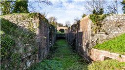
The Thames and Severn Canal is a canal in Gloucestershire in the south of England, which was completed in 1789. It was conceived as part of a canal route from Bristol to London. At its eastern end, it connects to the River Thames at Inglesham Lock near Lechlade, while at its western end, it connects to the Stroudwater Navigation at Wallbridge near Stroud, and thence to the River Severn.

It has one short arm (branch), from Siddington to the town of Cirencester. It includes Sapperton Tunnel, which when built was the longest canal tunnel in Britain, and remains the second-longest complete tunnel. There were always problems with water supply, as no reservoirs were built, while the summit section near the tunnel ran through porous limestone, and there were constant difficulties with leakage. Competition from the railways took much of the canal's traffic by the end of the 19th century, and most of the canal was abandoned in 1927, the remainder in 1941.

Since 1972, the Cotswold Canals Trust has been working to restore both the canal and the Stroudwater Navigation to navigably re-link the Thames and the Severn. A number of the structures have been restored, and some sections are now in water. A major step forward occurred in 2003, when a bid was made to the Heritage Lottery Fund for £82 million to restore both canals. The bid and the project had to be split into smaller sections, but £11.9 million was awarded in 2006 for phase 1a, which with matched funding will restore from 'The Ocean' at Stonehouse to Wallbridge on the Navigation, and from there to Brimscombe Port on the canal. In 2010, British Waterways gave Inglesham Lock to the Trust, and the Inland Waterways Association mounted a national campaign to fund its restoration (and 420 yards (380 m) of canal above). To re-open the whole canal some major engineering obstacles will need to be overcome.

Land owner permission not required.

View and discuss this location in more detail on Grey Arrows.

Co-ordinates: 51.69556, -1.956327 • what3words: ///vowing.stops.comply

The originator declared that this location was not inside a Flight Restriction Zone at the time of being flown on 20/11/2022. It remains the responsibility of any pilot to check for any changes before flying at the same location.

Where to fly your drone


Recently added locations

Tregoad Holiday Park (By lurch003)

Great place to stay, surrounded by fields and forests, and a great vantage point if you're brave enough to fly towards Looe Island

Land owner permission not required.

View and discuss this location on Grey Arrows.

Co-ordinates: 50.37805, -4.432871 • what3words: ///sectors.tunnel.fruits

Flagstaff Quarry, and The Hoveringham II shipwreck (By Banjonic)

We parked at Penmon Priory and asked the guy in the toll shed if we can get access to the quarry. He gave us the padlock code for the gate so we didn’t have to climb over it. An easy walk across some fields.
There is a ship wreck called the Hoveringham II off the bay which we wanted to get closer to from the quarry.

Land owner permission obtained.

View and discuss this location on Grey Arrows.

Co-ordinates: 53.30466, -4.049213 • what3words: ///waxer.country.takeovers

Kinlochleven overlooking Loch (By Airlessmean)

on the final push of my walk ii had this beautiful view!

Land owner permission not required.

View and discuss this location on Grey Arrows.

Co-ordinates: 56.71656, -4.962602 • what3words: ///digestion.tailing.stewing

Kings house Hotel (By Airlessmean)

bit of kings house in the morning :) nice clouds over the mountain making an awesome atmosphere!

Land owner permission not required.

View and discuss this location on Grey Arrows.

Co-ordinates: 56.652, -4.8401 • what3words: ///accordion.agency.webcams

Bridge of orchy (By Airlessmean)

was a stunning view !

Land owner permission not required.

View and discuss this location on Grey Arrows.

Co-ordinates: 56.51809, -4.770609 • what3words: ///breakaway.pairings.create

island I VOW (By Airlessmean)

passing rowardenan and ivernaid hotel i stopped at a point and captured this stunning little island in the water on the loch lomond

Land owner permission not required.

View and discuss this location on Grey Arrows.

Co-ordinates: 56.27769, -4.696804 • what3words: ///obstruct.vocal.oath

Spud Wood (By AlbionDrones)

Spud Woods in Lymm, park in the free car park, short walk over Grantham's Bridge - over the Bridegwater Canal - and then lots of options as to where to fly.

For a drone meet up turn right and follow the path to the meadow with the picnic bench and 2 other benches and its a nice open field to fly over alongside the woodland and canal - for the adventurous there are the woodland paths to fly through...

Walk straight ahead to the central clering, about 60m wide and about 1/4 mile long, bending left, sheltered between the trees..

Turn left and another much smaller meadow alongside the canal.

Easliy accessible with a shorter walk than Beacon Fell on what appears to be good solid ground.

A good few families walking, and dot walkers, but no-one had issue with the drones being flown, there are no 'no drone' signs, and nothing online I can find - owned by the Woodland Trust, who don't seem to have a drone policy on their website...

Land owner permission requirements unknown.

View and discuss this location on Grey Arrows.

Co-ordinates: 53.38314, -2.448541 • what3words: ///launched.showdown.redouble

Danraven Cliffs (By 20Five)

Dunraven is a great place to visit with the family. Beach, ice cream, castle grounds, woods and cliffside walks.

Parking is currently £5 cash for all day parking. If the main car park is full, which it will be, the warden will guide you to the overflow field which has plenty of spaces.

Wikipedia:
The cliffs are mostly formed of blue lias, a sequence of carboniferous limestone layers from the Triassic period, folded and tilted in places but otherwise level, while Witches Point is composed of Sutton Stone, a lighter-colored limestone which overlays the blue lias and represents an unconformity, with a gap between the two strata of around 150 million years.

Land owner permission not required.

View and discuss this location on Grey Arrows.

Co-ordinates: 51.44084, -3.596313 • what3words: ///treat.sisters.dizziness

Heights of Abraham Matlock (By Woody305)

The Heights of Abraham is a tourist attraction in Derbyshire.

It consists of a hilltop park on top of Masson Hill, accessed from the village by the Heights of Abraham cable car. The heights are named after a supposed resemblance to the Plains of Abraham, also known as the Heights of Abraham, in Quebec, Canada, where James Wolfe died in battle.

Amongst the attractions in the park, which has been open since Victorian times, are cavern and mine tours. There are also views of the dramatic scenery of the valley of the River Derwent. The cable car was opened in 1984 to provide easier access.

The Heights of Abraham are listed as grade II in the register of historic parks and gardens of special historic interest in England.

Land owner permission not required.

View and discuss this location on Grey Arrows.

Co-ordinates: 53.124, -1.554791 • what3words: ///kind.baseballs.activity

St James Church, Coventry (By BudgieUK)

This is a local parish church. The surrounding roads are quite quiet, and parking around the area is easy.

Land owner permission requirements unknown.

View and discuss this location on Grey Arrows.

Co-ordinates: 52.38885, -1.515566 • what3words: ///give.clock.pines


Show All Locations

Service provided by