×Filter Applied. Number of filtered matches found: 403

Where can I fly my drone in the UK and get £5,000,000 Public Liability Insurance cover? Welcome to Drone Scene!

Wondering where you can legally fly your drone? Looking for great places to fly? Looking for £5m Public Liability Insurance cover? Well look no further!

Welcome to Drone Scene, the place to find great drone flying locations in the UK, view images and videos posted by other pilots and share your flying locations in order to help other UK hobbyists find great locations where they can fly safely too.

Click on a marker pin to view details of that location. You can also add comments and discuss the location in our forum.

×You must login to see Airspace Restrictions, National Trust boundaries and other interactive map layers.

Where to fly your drone


Filtered locations

Brixham (By richrab)

Brixham Harbour is located on the southern side of Tor Bay and boasts one of the largest fishing fleets in the UK, plus a thriving fish market to support it.

Nice place to TOAL for good views of the Harbour and surrounding area.

Land owner permission not required.

View and discuss this location on Grey Arrows.

Co-ordinates: 50.40076, -3.517543 • what3words: ///river.tungsten.cooking

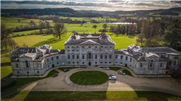
Tottenham House Great Bedwyn Wiltshire (By Kirky)

Tottenham house is a grade 1 listed English country house it sits between great bedwyn & Savernake forest, I’ve been meaning to try & fly this location for a while but had not realised it was under construction, after not wanting a wasted journey I still proceeded to fly,
I did do a bit of research on google & I shall add a couple of links, from what I’ve seen this place looks amazing when in tip top condition & would like to re visit when all work is done,
TOAL & parking was very easy I parked at saint Katherine's church great bedwyn, parked in a car park at the side of the church & walked down a bit of a muddy single track road remembering the location was to my left, where I then cut up through some trees which on looks towards the location, only thing you have to be really carful of is the over hanging trees which you can’t get away from, I hand launched the drone then hovered & slowly moved out from under the trees over a field,
I’m not sure when the renovation will be complete but that’s when it will be worth another visit,

https://en.m.wikipedia.org/wiki/Tottenham_House

https://www.wiltshiretimes.co.uk/news/23469658.billionaire-plans-turn-tottenham-house-family-home/

Land owner permission requirements unknown.

View and discuss this location on Grey Arrows.

Co-ordinates: 51.37406, -1.642842 • what3words: ///same.appealing.spirits

Ashton Gate Stadium (By richrab)

Ashton Gate home of the Bristol Bears.


Ashton Gate is a multi-use stadium in Ashton Gate, Bristol, England, and is the home of Bristol City football club and the Bristol Bears rugby union team. Located in the south-west of the city, just south of the River Avon, it currently has an all-seated capacity of 27,000

TOAL on Smyth Road next to Gores Marsh.
Avoid the Marsh as it is a Park and Bristol council forbid take off and land from parks within the city.

Land owner permission not required.

View and discuss this location on Grey Arrows.

Co-ordinates: 51.44022, -2.620379 • what3words: ///vibrate.places.elbow

St Michael the Archangel, Dundry. (By richrab)

The parish church of St Michael the Archangel in Dundry, Somerset, England has a tower which was built in 1484, with the rest dated 1861. It has been designated as a Grade I listed building.
The four-stage tower was erected, around 1484, as a landmark and is visible from many parts of Bristol

The rest of the church was built in 1861 by G.B. Gabriel, replacing the previous medieval building.

Land owner permission not required.

View and discuss this location on Grey Arrows.

Co-ordinates: 51.39901, -2.637392 • what3words: ///whips.puff.slick

Maiden Castle, Dorset (By Howard)

'Maiden Castle is one of the largest and most complex Iron Age hillforts in Britain. Its vast multiple ramparts enclose an area the size of 50 football pitches, and the site was home to several hundred people in the Iron Age (800 BC–AD 43).' (English Heritage)

There is a car park at the site and an area the size of 50 football pitches to fly from.

Land owner permission requirements unknown.

View and discuss this location on Grey Arrows.

Co-ordinates: 50.69471, -2.467675 • what3words: ///giraffes.request.speeded

St Andrews Church, Chew Magna (By ColinPeachey)

Plenty of parking in The Pelican pub car park, nice little village, can get the whole village in shot with not much height

Land owner permission not required.

View and discuss this location on Grey Arrows.

Co-ordinates: 51.36636, -2.609301 • what3words: ///scrub.visit.older

Abbots Pool (By richrab)

Abbots Pool is a popular walking area 2.5 miles west of Clifton Suspension Bridge.
There are plenty of photo areas above and along the pool, with a few small waterfalls leading off the main body of water.

Lots of tree cover and overhanging tree branches making almost a drone obstacle course.

Access via a small carpark off Manor road with a two minute walk to the pool.

Surrounding the pool is idyllic mature woodland containing some massive oak and beech trees. An abundance of wildlife can be found here and most of the area has been designated as a Local Nature Reserve. It was landscaped, using Pulhamite, an artificial type of rock of historic importance in the 1920s by the Wills family who owned the area until just after the Second World War.

Checking the information signs on prohibited activity, swimming and fishing is not allowed but no mention of Drones.

Land owner permission not required.

View and discuss this location on Grey Arrows.

Co-ordinates: 51.45617, -2.669125 • what3words: ///film.brush.quiet

Locksbrook Cemetery (By ColinPeachey)

I visit this place very week, you can pull in and park by the entrance lodge, or drive slowly through the cemetery to the twin chapels, great views over Bath and the Windsor bridge with all the 1000s of new student apartments being built, can be busy with dog walkers, but i have had at least 20 encounters with walkers in the cemetery over the years and every one was interested in the drones and the photos etc, and most subscribed to my Bath YouTube channel.

Land owner permission requirements unknown.

View and discuss this location on Grey Arrows.

Co-ordinates: 51.38588, -2.386524 • what3words: ///chained.full.lines

Beckfords Tower, Lansdown, Bath (By ColinPeachey)

Beckford's Tower, originally known as Lansdown Tower, is an architectural folly built in neo-classical style on Lansdown Hill, just outside Bath, Somerset, England. The tower and its attached railings are designated as a Grade I listed building. Easy parking in the entrance to Lansdown Cemetery, also great views over Bath and Weston Village.

Land owner permission not required.

View and discuss this location on Grey Arrows.

Co-ordinates: 51.40634, -2.378828 • what3words: ///spout.safe.crest

The Royal Crescent, Bath (By ColinPeachey)

The Royal Crescent is a row of 30 terraced houses laid out in a sweeping crescent in the city of Bath, England. Designed by the architect John Wood, the Younger, and built between 1767 and 1774, it is among the greatest examples of Georgian architecture to be found in the United Kingdom and is a Grade I listed building.

Land owner permission not required.

View and discuss this location on Grey Arrows.

Co-ordinates: 51.38678, -2.368533 • what3words: ///august.than.bind

Alexandra Park View Point, Bath (By ColinPeachey)

Parking bays right by the view point, can be quite busy with people taking selfies with virtually the whole of Bath in the background

Land owner permission not required.

View and discuss this location on Grey Arrows.

Co-ordinates: 51.37439, -2.35815 • what3words: ///fallen.future.libraries

Denny Island at Chew Valley Lake (By ColinPeachey)

Use the picnic area next to the car park, not the main car park with the café and child's play area.

Land owner permission not required.

View and discuss this location on Grey Arrows.

Co-ordinates: 51.34648, -2.607787 • what3words: ///wound.blemishes.crypt

Mells Village (By notnowcato)

Lovely historic village, Fine church and the Talbot is a good spot for lunch.

Land owner permission requirements unknown.

View and discuss this location on Grey Arrows.

Co-ordinates: 51.24129, -2.391796 • what3words: ///backward.inclines.homelands

AFC Bournemouth Stadium (By YGTMedia)

AFC Bournemouth is a professional association football club based in Kings Park, Boscombe, a suburb of Bournemouth, Dorset, England. The club competes in the Premier League, the highest division of English club football. Formed in 1899 as Boscombe, the club adopted their current name in 1971.

Parking in the Public car park next to the ground.

You can take off from the car park.

Avoid all match and event days as its busy. I filmed on a quiet Sunday afternoon.

Becareful of the flight restrictions being close to Bournemouth Airport.

Land owner permission requirements unknown.

View and discuss this location on Grey Arrows.

Co-ordinates: 50.73412, -1.837474 • what3words: ///sooner.powder.risen

The Pepper Box, Salisbury (By Kirky)

The Pepper Box, pepper box hill, Salisbury SP5 3QL.

A nice little place with gorgeous surroundings, a shame the day was very moody when visiting, stunning views all around that I can only imagine are even better on a nicer day, however i did not let this put me off,
The pepper box is on national trust but TOAL was literally 40 - 50 feet across the road off there land, I parked in the car park at the location & walked across the car park then across the cattle grid taking me across the road, where there is a gate slightly set back where's there's an entrance to a big field, I stayed this side of gate on some grass, great thing to the subject was only about 60 - 70 foot away from TOAL point,
was not overly busy but can imagine it does get busy so do be mindful if visiting, dog walkers, family etc, in all just a nice little place; well worth a visit.

Land owner permission requirements unknown.

View and discuss this location on Grey Arrows.

Co-ordinates: 51.02276, -1.698364 • what3words: ///chats.pampering.mash

Wilton House (By clinkadink)

History of Wilton House ...

Wilton Abbey was originally a 9th century nunnery.
Replaced by 12th century Abbey for Benedictine nuns.
Wilton Abbey was dissolved 1536 in the Dissolution of the Monasteries.
It was granted to the 1st Earl of Pembroke by 1544.
He built the first Wilton House in the 1540s.

Wilton House was rebuilt by 4th Earl of Pembroke from 1635.
He set up formal gardens, and planted the Cedars of Lebanon.
Much of the old Wilton House was destroyed in a fire about 1647.
The 4th Earl carried on re-building.
He died 1650.
Re-building completed 1653.

The formal gardens were removed, and grounds landscaped by the 9th Earl in 1730s-1740s.
He built the Palladian Bridge in 1737.
The Riding School was built by the 10th Earl in 1755.
Wilton was altered by the 11th Earl in 1801-1816.

Gardens and fountains were added by the 17th Earl.
Wilton is still seat of the Earl of Pembroke.

https://en.wikipedia.org/wiki/Wilton_House

Land owner permission not required.

View and discuss this location on Grey Arrows.

Co-ordinates: 51.07803, -1.859297 • what3words: ///celebrate.craters.task

Longford Castle (By clinkadink)

Longford Castle was originally built in the late 16th century during the reign of Queen Elizabeth I by the Gorges family to an unusual triangular plan. The caste was built with the proceeds of the contents of one of the Duke of Medina-Sidonia’s galleons which sank in the wake of the Spanish Armada.

In the 18th century the 2nd Earl of Radnor, employed the architect James Wyatt to transform it into a hexagonal palace; a project which was abandoned. It was left to the 4th Earl of Radnor and Victorian architect Anthony Salvin to complete Longford.

Longford Castle, is one of the grandest stately homes in Britain and has been the residence of three families in just over four centuries; the Gorges, the Coleraines, and for over three hundred years, the Bouveries, who continue to live there today.

Laurens Des Bouverie, a Huguenot, came to England from Flanders in 1568 fleeing religious persecution, settled in Kent, was a successful silk merchant, and his descendants acquired land and property which comprises the estates today. The family was ennobled in 1747 with Sir Jacob Des Bouverie becoming the First Viscount Folkestone while his son, William, was created an Earl in 1765. Longford has continued to be home to the Earls of Radnor ever since.

https://en.wikipedia.org/wiki/Longford_Castle

Land owner permission not required.

View and discuss this location on Grey Arrows.

Co-ordinates: 51.03918, -1.75657 • what3words: ///long.sums.drooling

Shipham Hill Quarry (By Kirky)

At the top of the gorge near cheddar, 360 degree stunning views, bit of a nightmare to find this one when using the sat nav, which takes you to warrens hill ( where there is not entry for the quarry ) ignore warrens hill & head for mendips raceway, warrens hill road shipham, there is two sides to warrens hill, so its easier to head for the raceway which will take you there, go past the raceway & you will see places to Toal to your left & right, I Toal'd at the side of a farmers field down the bottom to my right, where the owner turned up in his tractor & was absolutely fine, he got out of his tractor & wanted to talk about his drone he got for Christmas, looked at my screen & said there amazing things,
Apart from that there was no one there, you may get the odd car or van pull up which I see twice at first, I'm assuming just people on a break or a little rest or admiring the views,
gorgeous place would visit again as there's many other lovely places nearby.

NOTE, when you Toal from anywhere within this vicinity do be extra carful as when you are facing west / south west behind you is bristol airports FRZ which is between 900 - 1000 metres behind you.

Land owner permission requirements unknown.

View and discuss this location on Grey Arrows.

Co-ordinates: 51.29402, -2.773533 • what3words: ///demanding.litigate.quietest

Whatley Quarry, Frome (By Kirky)

This place has absolutely breath taking views, situated in Frome, TOAL & parking is an absolute walk in the park.

Where I’ve placed the marker, park there at the end, (if you’re driving) then to your left is an entrance to a bridal way & a small piece of woodland, you walk up through the woods & to your left it opens up to a set of about a dozen shallow steps & you have perfect 180 views at the top, it is fenced off & very safe.

Directions, head to Frome to a place called Mells, you look for a road called Knaptons Hill, do a left onto Holes lane where a few yards down the road you see a cross road with an old red telephone box there, do a left at the junction opposite the red phone box (can’t find a name of the road) single track road you will go along which comes to a dead end which is fine to park, easy to turn around too.

It was completely deserted when I was there but a breath of fresh air, I can imagine it may get people, and dog walkers in & around at times so be mindful of that, but myself & my friend who is from that area, she said it is always very quiet & many many places in the area alike, worth a visit any day !

Stunning place.

Land owner permission requirements unknown.

View and discuss this location on Grey Arrows.

Co-ordinates: 51.23157, -2.394998 • what3words: ///amuses.makeovers.blogging

Lands End (By TMVideos)

The iconic Lands End. You can park in the main carpark which is open all year round. Take time to look around as there is lots of free stuff here and also paid parts. There are arts and crafts studios to the left of the complex. There are also cafes and restaurants.

We took the 1mile walk to Sennen to the north which is an easy walk but has a bit of a hill to get into Sennen. (There are flight restrictions in Sennen due to Lands End Airport)

Brilliant Walk on a sunny day!!

Land owner permission requirements unknown.

View and discuss this location on Grey Arrows.

Co-ordinates: 50.0656, -5.71246 • what3words: ///wider.positions.foreheads

Maenporth to Swanpool (By TMVideos)

This was taken on a walk from Maenporth to Swanpool.

Maenporth and Swanpool have a good carpark that you can park in free from Oct-March. There is a cafe at both beaches open all year round.

The walk is about 1.8miles each way, takes about 40-50mins each way.

Check out my other listings for this area
https://dronescene.co.uk/where-to-fly-drone/maenporth-beach/south-west/3089
https://dronescene.co.uk/where-to-fly-drone/swanpool-beach/south-west/2515
https://dronescene.co.uk/where-to-fly-drone/gyllyngvase-beach/south-west/2687

Land owner permission not required.

View and discuss this location on Grey Arrows.

Co-ordinates: 50.13373, -5.079888 • what3words: ///oasis.atomic.spray

Maenporth Beach (By TMVideos)

Maenporth has a good carpark that you can park in free from Oct-March. There is a cafe open all year round and a lovely walk to the left of the beach which will take you to Swanpool Beach.

Land owner permission not required.

View and discuss this location on Grey Arrows.

Co-ordinates: 50.12543, -5.093817 • what3words: ///green.deals.flat

Milk Hill (By clinkadink)

Milk Hill is the highest point in Wiltshire and is part of the Pewsey Downs, a rolling set of chalk grassland hills between Devizes and Pewsey which are prominent in the landscape and almost invite the passer by to park up and take a stroll along the ridge. At just over 1,000 feet, they are high enough to offer fantastic views of the Pewsey Vale and beyond but low enough to make walking over them not too strenuous.

https://en.wikipedia.org/wiki/Milk_Hill

Land owner permission not required.

View and discuss this location on Grey Arrows.

Co-ordinates: 51.37662, -1.851694 • what3words: ///geek.rooster.widest

Giant's Grave (By clinkadink)

The Giant’s Grave is a long barrow, which is a burial place of Britain’s early farming communities and amongst the oldest visible field monuments (from Early and Middle Neolithic periods 3400-2400 BC).

Used for communal burial, often with only parts of the human remains selected for interment, all are considered to be important. Giant’s Grave was partly excavated in 1865, when a primary deposit including up to four skeletons was discovered with a leaf shaped flint arrowhead close by.

https://en.wikipedia.org/wiki/Wilcot

Land owner permission not required.

View and discuss this location on Grey Arrows.

Co-ordinates: 51.36768, -1.763055 • what3words: ///speeches.flattery.require

Shoulsbury Castle and Five Barrows (By Howard)

Take off and landing was from the side of the road; there are gateways and laybys nearby that facilitate this.

Land owner permission requirements unknown.

View and discuss this location on Grey Arrows.

Co-ordinates: 51.13623, -3.85169 • what3words: ///pure.playing.overheat

Bideford, Devon (By Howard)

I parked in the riverside car park in East-the-Water, facing the Quay and downstream from the Old Bridge. All the flying was at a good height over the river.

Bideford is a port town that has a history that goes back centuries. The Torridge is fully tidal here with a big difference between high and low tides[ I'd say these photos are in the middle of the range.

I was brought up in Bideford but this is the first chance I had to fly a drone there - there's lots of potential all around here!

Land owner permission requirements unknown.

View and discuss this location on Grey Arrows.

Co-ordinates: 51.01661, -4.203429 • what3words: ///ultra.follow.cuddled

Horton Tower (By YGTMedia)

Horton's Tower - Said to have once been the tallest non-religious building in Britain, Horton's Tower near Chalbury Common is a classic example of a folly - monuments built by rich eccentrics with no obvious purpose.

Horton Tower: W3W //smiled.elbowing.strikers

Parking: W3W //smiling.adapt.shops

Land owner permission requirements unknown.

View and discuss this location on Grey Arrows.

Co-ordinates: 50.86009, -1.958131 • what3words: ///risk.reckon.helpfully

Medieval Strip Fields, Taddiport (By Howard)

The strip fields originally supported a leper colony. These two particular strips are what remain of between seven and a dozen fields (reports vary) which were reserved for cultivation by lepers who lived in the village from the 14th until the 17th century when leprosy was eradicated from Britain. The Tythe Map of 1838 shows that seven strips were still in use, though the lepers were long gone.

There are a number of locations to fly from - there is some car parking close to the river at New Bridge, and the strip fields can be viewed from the car park in the town above the river.

Land owner permission requirements unknown.

View and discuss this location on Grey Arrows.

Co-ordinates: 50.94758, -4.148873 • what3words: ///kebab.reporters.initial

Bigsweir Bridge, Wye Valley (By clinkadink)

Parking: 51.742231, -2.671660
TOAL: 51.742878, -2.670014

Wasn't planning this one, but it was on my return journey back south down the Wye Valley. A very pretty bridge over the River Wye.

Bigsweir Bridge is an 1827 road bridge crossing the River Wye, straddling the boundary between the parish of St. Briavels, Gloucestershire, England, and Llandogo, Monmouthshire, Wales.

The elegant cast-iron road bridge was built in 1827 as part of the new turnpike road constructed up the lower part of the Wye valley between Chepstow and Monmouth. The bridge connects the English and Welsh sides of the river, with an abandoned but recently restored toll house on the Welsh side. The bridge comprises a single arch of 50 metres (55 yd) , and was designed by Charles Hollis of London and cast at Merthyr Tydfil.

https://en.wikipedia.org/wiki/Bigsweir_Bridge

Land owner permission not required.

View and discuss this location on Grey Arrows.

Co-ordinates: 51.74274, -2.669498 • what3words: ///shrimps.eventful.drags

Symonds Yat Rock, Wye Valley (By clinkadink)

Parking: 51.837870, -2.635745
TOAL: 51.841040, -2.634554

If anyone gets the chance to pass by here, stop and visit. It is amazing. The views are like being in the Alps. I parked in a Pay & Display carpark, I think it was £3 for 2 hours. The walk from the carpark to the rock is about 20 minutes up an easy path. You pass a log cabin cafe half way up (or down) for refreshments. I had a coffee (black no sugar £2). You cross a foot bridge across the main road below and then you on the rock - with panoramic views 270 degrees over the Wye Valley and river. The photos don't do it justice.

Symonds Yat Rock is home to an Iron Age hillfort built around 2500 years ago. The area is now a Scheduled Ancient Monument. The remains of the ramparts can still be seen in the form of a series of banks and ditches.

More recently, Yat Rock and the Wye Valley are known as the birthplace of British tourism. They have been used as a travel destination since the 18th century after they were popularised by the Reverend William Gilpin, the pioneer of the ‘Picturesque’ movement. His writings influenced the popularity of English landscape painting and inspired the Romantic poets.

Symonds Yat Rock viewpoint is well known as one of the best places in the country to watch Peregrine Falcons. However, with a little patience, there are many other birds that you can seen here. Goshawks can be viewed in detail, Sparrowhawks are frequent and breed in the trees in the valley as do Buzzards which can be seen from above whilst soaring. Ospreys also often stop here in the spring and autumn migration. Tawny Owls are sometimes seen roosting and hooting males are occasionally heard during the day. Barn Owls, Ravens and Kestrels also usually nest nearby.

https://en.wikipedia.org/wiki/Symonds_Yat

Land owner permission not required.

View and discuss this location on Grey Arrows.

Co-ordinates: 51.84103, -2.634689 • what3words: ///city.handyman.amending

St Briavels Castle, Wye Valley (By clinkadink)

Parking & TOAL: 51.737865, -2.641342

It was a complete white out due to low cloud. I was hoping that Briavel would have been high enough for a cloud inversion, alas no. Too good to pass up the chance though, so grabbed a moody, misty shot of the small castle grounds.

Built in the early 12th century, St Briavel’s was an important royal castle on the frontier with Wales and the administrative and judicial centre of the Forest of Dean – a royal hunting ground where the game was protected and the king alone allowed to hunt.

Edward I added a fine twin-towered gatehouse to St Briavel's in 1292. During his reign the castle was a crossbow bolt factory, using local Forest of Dean iron to produce weapons for his campaigns against the Welsh and Scots. After the conquest of Wales the gatehouse became a debtor's prison, and the castle is now a youth hostel, set in wonderful walking country.

https://www.english-heritage.org.uk/visit/places/st-briavels-castle/history/

Land owner permission not required.

View and discuss this location on Grey Arrows.

Co-ordinates: 51.73817, -2.640824 • what3words: ///startles.pram.ample

Lake 6 / Church Pool, Cotswold Water Park (By BudgieUK)

I was attending an event at the hotel, but it was a short walk to the Gateway Centre .... I took the signed footpath by the side of the centre, and TOAL was along the shore of the lake. I searched online, and looked at all the signs and notices I could find and there is no mention of drones.
This area is designated as a SSSI, but it was clear that there was no risk to breeding birds etc.
There is ample parking close by to the Gateway Centre.
Note: this is close to a couple of military bases, and DJI seem to think that this close to an imaginary NFZ, but there are no restrictions at this point

Land owner permission not required.

View and discuss this location on Grey Arrows.

Co-ordinates: 51.6713, -1.895665 • what3words: ///prefix.newlywed.grapevine

Torridge Vale / Dairy Crest milk factory (By Howard)

The derelict former Dairy Crest creamery, Taddiport, Great Torrington, Devon; the so-called Legend Dairy (say it out loud).

The dairy was founded in 1873-4 and closed in 1993. Recent discoveries of asbestos have slowed development of the site, which has been sold for housing. Urbex types have been here many times and there's plenty of graffiti amid the scenes of general desolation.

A road runs through the site and there is parking nearby. The buildings are off-limits but there are gaps in the security everywhere. It is said there have been two suicides at the site and that others have been killed or seriously injured in accidents.

Land owner permission requirements unknown.

View and discuss this location on Grey Arrows.

Co-ordinates: 50.94847, -4.15575 • what3words: ///responses.stylists.harvest

Blackpool Sands (By grandad1950)

Another very fine and unspoilt Devon cove that seldom gets crowded hidden in a valley. Easy parking and TOAL on the beach. Coastal scenery, farms, valley, and woodland ready to be photographed.

Land owner permission requirements unknown.

View and discuss this location on Grey Arrows.

Co-ordinates: 50.31941, -3.609996 • what3words: ///climbing.orders.stunt

Cam Long Down Hillfort (By clinkadink)

Parking & TOAL: 51.709437, -2.299309

Slight signs of the earthworks of a remaining hillfort can be seen on the top of Cam Long Down. On the north side of the hill are several stretches of a slight bank. At the east end of the hill are the remains of "many ancient pit dwellings" among which have been found large quantities of worked flints.

Locals were told as children that the devil decided to dam up the river Severn and drown the people of Gloucestershire in revenge for them building to many churches above Dursely. He filled his wheelbarrow with a big chunk of the Cotswold's, but while taking a rest he met a shoemaker with lots of shoes around his neck to mend. The devil asked the shoemaker direction to the river. The shoemaker told him it was a long way and that he himself had wore out so many shoes getting there. The devil lost heart and dumped the wheelbarrow full of the stone which became Cam Peak. Cam Long Down is thought to be associated with King Arthur and may be the site of the legendary battle of Camlan.

Land owner permission not required.

View and discuss this location on Grey Arrows.

Co-ordinates: 51.69394, -2.327069 • what3words: ///wizard.longingly.bright

Beesands on the south Devon coast (By grandad1950)

Easy parking and TOAL. Small hamlet and fishing boats on the beach with distant views to Start Point. It is on the south west coastal path. If you drive there are very narrow single track lanes to negotiate

Land owner permission requirements unknown.

View and discuss this location on Grey Arrows.

Co-ordinates: 50.25275, -3.656661 • what3words: ///argued.internet.thousands

Kingsbridge Estuary (By grandad1950)

Not a lot of parking . TOAL by the bridge or the sailing club. Good views of the estuary and the old bridge and the surrounding area.

Land owner permission requirements unknown.

View and discuss this location on Grey Arrows.

Co-ordinates: 50.27507, -3.762806 • what3words: ///memory.eternally.buns

Royal Wootton church (By Rustyo200le)

TOAL from field just off Whitehill Lane. There is a small lay-by to park just opposite the field. St Bartholomews church and Town Hall can be easily reached from here.

Land owner permission requirements unknown.

View and discuss this location on Grey Arrows.

Co-ordinates: 51.54128, -1.905323 • what3words: ///tailing.logbook.automate

Plymouth Hoe (By grandad1950)

Parking easy around the Hoe and lots of choice to TOAL. Plenty to see from the lighthouse, the sound, tinside Lido, coast etc. Be aware to stay away from the Marine citadel on the east side of the Hoe.

Land owner permission requirements unknown.

View and discuss this location on Grey Arrows.

Co-ordinates: 50.36457, -4.141384 • what3words: ///remind.garage.lanes

New Lake, Bourton (By Prometheus)

Park in a small pull in next to lake where WTW coordinates take you.

Land owner permission requirements unknown.

View and discuss this location on Grey Arrows.

Co-ordinates: 51.09484, -2.331719 • what3words: ///Object reference not set to an instance of an object.

Woodhenge (By MasterYeti)

This is an English Heritage site so their rules and regs apply for TAOL within the site boundaries. There is plenty of scope to park and fly from public land here though as there is a road that passes directly alongside it with a picnic area on the other side.
I would recommend to definitely be wary though as you are right on the edge of Boscombe Down airspace with Netherhaven also just to the north. Keep your eyes wide open, as being a military flying area there are often aircraft low flying especially helicopters.

Woodhenge is a Neolithic Class II henge and timber circle monument within the Stonehenge World Heritage Site in Wiltshire, England. It is 2 miles (3.2 km) north-east of Stonehenge, in Durrington parish, just north of the town of Amesbury.

More information on the English Heritage site: https://en.wikipedia.org/wiki/Woodhenge

Land owner permission requirements unknown.

View and discuss this location on Grey Arrows.

Co-ordinates: 51.18936, -1.785777 • what3words: ///tornado.wealth.fortress

Severn Beach (By Jonaldo)

Parking is available on Beach Road. This area can be very windy but on a calm day is a nice place to fly.

Land owner permission requirements unknown.

View and discuss this location on Grey Arrows.

Co-ordinates: 51.56391, -2.666872 • what3words: ///goggle.truck.blush

Middle Drove, Glastonbury (By Prometheus)

Park in entrance to a farm gate if not being used by farmer.

Land owner permission not required.

View and discuss this location on Grey Arrows.

Co-ordinates: 51.12987, -2.7096 • what3words: ///zapped.resold.spreading

Croyde Beach (By Prometheus)

Lots of parking. Just follow the VW camper vans and surfers to car park.

Land owner permission not required.

View and discuss this location on Grey Arrows.

Co-ordinates: 51.12755, -4.239006 • what3words: ///renew.swerving.ventures

Boscawen-un stone circle (By Prawntot)

The Boscawen-un farm lane, off the A30 is good for short parking, but do so considerately and don't park in teh farm yard itself. Footpath from the farm yard takes you to the stone circle. It's a stunning location. Although not in an FRZ, it is extremely close to one; Lands End Airport ATC are extremely helpful if you seek prior permission to fly and notify them before and after your flight.

Land owner permission requirements unknown.

View and discuss this location on Grey Arrows.

Co-ordinates: 50.09181, -5.615665 • what3words: ///lanes.bloom.hopping

Longships Lighthouse (By Prawntot)

Boat hire available from various places in and around Sennen Cove. There are also two close(ish) points on land to fly from - a promontory near Lands End or the Sennen Cove look out point (featured in my YouTube video). Fully charged battery and minimal / onshore wind required ;o)

Land owner permission requirements unknown.

View and discuss this location on Grey Arrows.

Co-ordinates: 50.0668, -5.746815 • what3words: ///loaning.rots.against

Thornhill Lakes, Lechlade (By clinkadink)

Parking & TOAL: 51.699347, -1.712372

The western half of Thornhill Hill Lakes are within RAF Fairford FRZ, so take care if you fly here.

A collection of sustainable, bespoke homes set within their own private nature reserve at The Lakes in the beautiful Cotswolds. Each home looks onto outstanding natural beauty of wild, plush greenery, watercourses and stunning lake views. The Bowmoor design offers the owner luxury accommodation spread over 3,902 sqm and two floors. Optional Cantilevered panoramic windows and roof terraces amongst the many other bespoke options available.

https://www.thelakesbyyoo.com/

Land owner permission not required.

View and discuss this location on Grey Arrows.

Co-ordinates: 51.69465, -1.72104 • what3words: ///diver.riper.hurricane

Clovelly (By Rustyo200le)

There is a large free car park at top of the village, but there is an entry fee to enter £8.75 for Adults. The village is built on a steep cobbled street. I took off from the pebble beach at the bottom of the Village. If you don't fancy the hike back up the hill there is a Land Rover which will take you back to the top for a small fee.

Land owner permission not required.

View and discuss this location on Grey Arrows.

Co-ordinates: 50.99823, -4.397798 • what3words: ///moves.joystick.scripted

Brent Knoll Camp (By DroneGeek)

Brent Knoll is a 137-metre-high (449 ft) hill on the Somerset Levels, in Somerset, England. It is located roughly halfway between Weston-super-Mare and Bridgwater, 2.5 miles (4.0 km) from the Bristol Channel coast at Burnham-on-Sea. At the foot of the hill are two villages East Brent and Brent Knoll, which takes its name from the hill but was previously called South Brent.

Brent Knoll Camp has seen human settlement since at least the Bronze Age, becoming an Iron Age Fort about 2,000 BC, which covers an area of 1.6 hectares (16,000 m2)

The Romans used its summit as a fortification.

Parking is available in local streets. A footpath runs from Church Lane, close to St Michael's Church - although this road is narrow.

Land owner permission not required.

View and discuss this location on Grey Arrows.

Co-ordinates: 51.25407, -2.945503 • what3words: ///pelted.fries.vowel

Fosbury Camp Hillfort (By clinkadink)

Parking & TOAL from side of the country lane.

Sitting atop Knolls Down, on the edge of Wiltshire, lies Fosbury Camp – an iron age hillfort and scheduled monument. Attributed to the family tribes of the Atrebates, Fosbury was probably constructed during the Middle Iron Age and although never quite completed this impressive fort rests majestically above the deep valleys and wooded slopes of the North Hampshire Downs.

Most of the site is open access land and accessible from two footpaths, one leading through the top of Oakhill Wood and then into the ‘North Gate’. The other path comes up from Woodside near Vernham Dean – past still visible field terraces to the fort’s main entrance; the East Gateway.

Standing at this portal between a prominent tree covered bank and ditch it’s easy to visualise the original warrior builders, our ancestors, staring back at us spears & slingshot ready! To the left is an incredible giant, an old gnarled beech tree, straight from Tolkein’s Lord of the Rings! Go past here and into the expansive grassy encampment itself and the path follows along the top of the defensive bank with fabulous views both east and west across to Conholt, Chute Causeway Roman Road and further into Hippenscombe valley far down below.

https://en.wikipedia.org/wiki/Fosbury_Camp

Land owner permission not required.

View and discuss this location on Grey Arrows.

Co-ordinates: 51.30671, -1.542317 • what3words: ///gullible.lyrics.eyebrows

Tidcombe Long Barrow (By clinkadink)

Parking & TOAL on the side of the lane.

Dating back to the Early and Middle Neolithic periods (3400-2400 BC). The monument includes a long barrow set on the crest of a NW-facing slope in an area of undulating chalk downland. It survives as a substantial earthwork, broadly rectangular in plan and orientated north-south. The barrow mound is 54m long, 24m wide and varies in height between 3m at the north end and 4m at the chambered south end. The chamber has been partly excavated and consequently appears as a hollowed area containing four large sarsen blocks. A further hollow runs the length of the mound along the top of the monument. This may represent the earliest disturbance of the site which is believed to have been in the 18th century. Flanking the mound are ditches, from which material was quarried during the construction of the monument. These run parallel to the east and west sides of the mound. The eastern ditch survives to 8m wide and 0.5m deep. The western ditch has been largely infilled over the years but can still be traced on the surface as a low earthwork.

https://www.hiddenwiltshire.com/post/tidcombe-hippenscombe-and-the-devil-s-waistcoat

Land owner permission not required.

View and discuss this location on Grey Arrows.

Co-ordinates: 51.32046, -1.590103 • what3words: ///hazy.mallets.rules

Chisbury Camp Hillfort (By clinkadink)

Parking & TOAL from the side of the road.

Chisbury Camp Hillfort, with bivallate & trivallate defences. Storage pits containing Iron Age ‘C’ & pre-Belgic pottery. Silver coin of Verica also a decorated strap union found by a metal detectorist.

The hillfort is multivallate, possessing two, and in some places three circuits of defences which in places are over 50m in overall width. These together enclose an irregular oval area of approximately 5.6ha. The hillfort is bisected by a modern road which utilising gaps in the north-east and south east sides of the defences which may represent the original entrances. Observation of 20th century disturbances has produced evidence of urns, bronze swords and of storage pits containing Late Iron Age pottery.

https://en.wikipedia.org/wiki/Chisbury

Land owner permission not required.

View and discuss this location on Grey Arrows.

Co-ordinates: 51.39209, -1.600208 • what3words: ///examples.shelving.crunching

Polperro (By Jane1)

Flight was from a side walk at Polperro. There were no people around. Lots of seagulls around. Care to be taken.

Land owner permission requirements unknown.

View and discuss this location on Grey Arrows.

Co-ordinates: 50.33062, -4.512921 • what3words: ///monopoly.attending.reflected

Littlecote Roman Villa (By clinkadink)

Parking / TOAL: 51.432341, -1.566057

Free parking is available 100m to the east of the site.

The Roman villa was initially built in about 60AD near the site of a Roman guard post covering a crossing of the River Kennet. Successively rebuilt and enlarged over the next two centuries, in its heyday it boasted 60 rooms, two thermal baths and a number of mosaic floors and hypocausts. The magnificent surviving mosaic floor was built in the mid 4th century. Its central feature depicts Orpheus, god of the underworld and musician to Apollo. It is thought that this was a homage to a religious cult associated with Apollo and Bacchus which flourished at that time. The quality of the mosaic design and the rarity of its overall configuration, with what would have been three semi-circular apses at one end, make it one of the outstanding Roman mosaics in Britain. It is now protected by a roof and there is a raised viewing platform.

https://en.wikipedia.org/wiki/Littlecote_Roman_Villa

Land owner permission not required.

View and discuss this location on Grey Arrows.

Co-ordinates: 51.43335, -1.569484 • what3words: ///metals.lobbed.immediate

Littlecote House (By clinkadink)

Parking / TOAL: 51.432341, -1.566057

Parking is free and easily accessible to the west of the house (see coordinates above).

Littlecote is not one house but three, the earliest dating back to around 1250. The medieval manor was built by the de Calstone family which in 1415 was passed to the Darrell family who added the Tudor manor. The Pophams acquired the house from the Darrells in 1589 and added the Elizabethan manor.

Because of an alleged curse placed on the house, in 1762 there was no male Popham heir. The heiress, Anne Popham, married General William Leyborne and their son Edward William Leyborne had to add the name Popham to his own in order to inherit.

Much of the house as it exists today was constructed by this family in the laye 16th century. The house remained in the hands of the Leyborne Pophams until 1929 when it was sold to the Wills family. They sold it to the entrepreneur Peter de Savary in 1986. It was bought in 1996 by Warner Holidays, part of the Bourne Leisure Group, who built the present hotel in 1997.

https://en.wikipedia.org/wiki/Littlecote_House

Land owner permission not required.

View and discuss this location on Grey Arrows.

Co-ordinates: 51.43139, -1.561199 • what3words: ///text.lushly.almost

Potterne Crop Circle (By clinkadink)

Parking & TOAL: 51.331328, -2.003097

Just outside Potterne, a large crop circle has been made.

Potterne lies to the south of Devizes on the A360 road to Amesbury and Salisbury. The village is on Gault and Upper Greensand, between the chalk of the Marlborough Downs and Salisbury Plain. Part of the eastern edge of the parish is on Oxford and Kimmeridge clays. There are two streams in the parish, one in the north flowing eastwards, and one in the south flowing southwards and then eastwards. Little Tree on One Tree (Little Tree) Hill is said to have been planted to commemorate the battle of Waterloo (1815) at the top of Potterne Field, at 145 metres above sea level. It is a place remembered by Potterne 'Lambs' wherever they may be. Potterne people are known as 'Lambs' because of their boisterous and unruly behaviour in the 19th century.

The name Potterne is generally taken to mean 'the building for pots, or where pots were made'. It has been suggested that it could also refer to the 10th century font in the baptistery connected to the Saxon church. This would have been used for people from a large area around Potterne. The community here was important for two or three centuries before Devizes was established.

https://en.wikipedia.org/wiki/Potterne

Land owner permission requirements unknown.

View and discuss this location on Grey Arrows.

Co-ordinates: 51.33024, -2.000383 • what3words: ///carriage.truckload.storeroom

Furze Knoll Crop Circle (By clinkadink)

Parking & TOAL: 51.393230, -1.961067

Just below Furze Knoll, a giant crop circle has recently been made. It sits in between Avebury and Devizes.

Furze Knoll is a unique, prominent wooded knoll, but it does not seem to have anything of historical significance written about it. But given its prominence in the landscape, the scale and size of it, the fact that it is close to multiple tumuli, earthworks and the Wansdyke, surely means it must have been of significance at some point in time.

Land owner permission not required.

View and discuss this location on Grey Arrows.

Co-ordinates: 51.39058, -1.969462 • what3words: ///apartment.slouched.outfit

Broad Hinton Crop Circle (By clinkadink)

Parking/TOAL: 51.484670, -1.841839

Currently, there is a large crop circle at this location.

Broad Hinton is a village and civil parish in Wiltshire, England, about 5 miles (8 km) southwest of Swindon. The parish includes the hamlets of Uffcott and The Weir.

There are several barrows in the parish, notably on Hackpen Hill. East of The Weir is a Romano-British burial site and possibly the remains of a house of that period.

Bincknoll Castle is an earthwork on a promontory on a chalk escarpment in the northernmost part of the parish. It is the remains of a fortified enclosure, possibly Romano-British in origin, that was re-used in the Middle Ages.


Land owner permission not required.

View and discuss this location on Grey Arrows.

Co-ordinates: 51.48269, -1.851955 • what3words: ///pursuing.sofas.affirming

River Brue, Ansford (By Prometheus)

What Three Words: apron.overlooks.grit
Bridleway WN 2/40 Small pull in type parking area where bridleway meets Wyke Road. River Brue meanders along here but is overgrown on both sides.

Land owner permission requirements unknown.

View and discuss this location on Grey Arrows.

Co-ordinates: 51.10473, -2.495248 • what3words: ///catchers.lease.stews

Lodge Hill, Castle Cary (By Prometheus)

Free parking in Castle Cary. Walk along High Street and walk in to 'Paddock Drain', which leads to Lodge Hill.

Land owner permission requirements unknown.

View and discuss this location on Grey Arrows.

Co-ordinates: 51.08589, -2.507363 • what3words: ///cleanest.afternoon.swung

Cadbury Hill Fort (By Prometheus)

What Three Words for the Hill Fort is tight.curls.apprehend

There is a free car park for the Hill Fort What ThreeWords for the car park are excavated.vitals.oldest

The pedestrian route to the top of the fort is signposted, i.e. walk right out of the car par and then turn left into a steep lane between two cottages. The walk up the lane is steep in places but well worth it. From car park to top of the hill took me around 15 minutes, mostly because I kept stopping. Great views across Somerset.

Land owner permission not required.

View and discuss this location on Grey Arrows.

Co-ordinates: 51.0242, -2.531404 • what3words: ///spelled.seducing.thinking

Gyllyngvase Beach (By TMVideos)

You can park along Cliff Road or if you like you can park in Swan Pool Car Park and then walk to Gyllyngvase. Its a great walk and some nice spots to fly along it.

Land owner permission requirements unknown.

View and discuss this location on Grey Arrows.

Co-ordinates: 50.14462, -5.066669 • what3words: ///cube.market.dices

Will’s Neck, Triscombe, The Quantocks (By Crevitz)

Free parking next to Triscombe Stone (labelled on map). Place is favoured by mountain bikers.

I walked up to Will's Neck, to find a composition for my Camera Setup, as I had some time to kill before sunset - I sent the drone up.

Photo is edited; namely a HDR stack.

Land owner permission not required.

View and discuss this location on Grey Arrows.

Co-ordinates: 51.11074, -3.195412 • what3words: ///adventure.rephrase.monk

Church of the Holy Cross, Ashton Keynes (By clinkadink)

Parking & TOAL: 51.649104, -1.940978

The church we see today was begun in the 12th century but may stand on the site of an earlier building erected by the monks of Cranborne Abbey. After 1102 the church was appropriated by Tewkesbury Abbey, which held the right of presentation until the Reformation.

https://en.wikipedia.org/w/index.php?title=Ashton_Keynes&oldformat=true#Parish_church

Land owner permission not required.

View and discuss this location on Grey Arrows.

Co-ordinates: 51.64834, -1.941073 • what3words: ///scars.shortens.pitchers

Hamworthy Park (By foginwater)

There is a pay and display carpark. Be aware there is a playground nearby and dog walkers along the path. Nonetheless it's a large park with plenty of space to find a quiet corner to TOAL.

Land owner permission requirements unknown.

View and discuss this location on Grey Arrows.

Co-ordinates: 50.71001, -2.004031 • what3words: ///modes.tags.poet

Washfield - Devon Countryside (By foginwater)

Parked on land owners property and had permission from land owner to reach this spot. The road here is very narrow so there aren't many places to pull over and park but I did come across some lay-bys. There will be some public paths that you can explore which will offer some TOAL area. Be very careful and aware of A361 which runs very close to this spot.

Land owner permission obtained.

View and discuss this location on Grey Arrows.

Co-ordinates: 50.92252, -3.515526 • what3words: ///skid.blindfold.example

Powerstock Villiage (By foginwater)

Spent a week in a Shepherds Hut here. Land owner gave me permission to TOAL from one of the paddocks. I gave him this image for free to use as he pleases. Amazing bit of countryside. There only hazards I could note were other birds (which mostly stayed away), and farm animals on the ground that might have been spooked but the drone TOAL. They were all in their respective fields and penned away. However just before I took off the first time, 2 pigs got spooked by something and jumped through an electified fence right near me and I had to abandon take off for a few minutes while the farmer and his family tried to catch them - just goes to show even in an empty field where you think nothing will disturb you ... something just might jump out at you.

Land owner permission obtained.

View and discuss this location on Grey Arrows.

Co-ordinates: 50.76056, -2.685613 • what3words: ///clicker.correct.enormous

Osmington Mills (By foginwater)

I arrived during high tide so decided to take off from next to the Smugglers Inn carpark. Found a quiet corner as far away from people as possible ( please be aware of the overhead power line running through the car park and towards town). I just made sure I was as far away from it as possible. Wind was very calm that day too.

Land owner permission not required.

View and discuss this location on Grey Arrows.

Co-ordinates: 50.63505, -2.376148 • what3words: ///highs.numeral.decisive

Monmouth Beach (By foginwater)

There is a pay and display parking lot near the beach. Be sure to time your flight with low tide. Be aware of the tide because it is a bit of a long trek (10-15 mins depending on personal dexterity and speed) to get out to the areas of the beach that have very large slabs of stone (with fossils on them) that you can easilly TOAL from. It is a very rocky beach, so be sure to prepare yourself for that with good shoes and bring anything else you might need because it's a bit of a long scramble over large stones to get back to the carpark.

Land owner permission not required.

View and discuss this location on Grey Arrows.

Co-ordinates: 50.71627, -2.951245 • what3words: ///reduce.overt.wages

Pendennis Castle (By DeanoG60)

Pendennis Castle in Falmouth, Cornwall. Take off from Castle Beach it's easy to find a quiet spot even at busy times. Roadside parking on Cliff Road is available but can be a pain to find a space sometimes.

Nice little beach side cafe a bit further down at Gylly Beach as well for some refreshments.

Land owner permission requirements unknown.

View and discuss this location on Grey Arrows.

Co-ordinates: 50.14687, -5.047277 • what3words: ///hears.lower.chair

River Avon at the Kellaways (By Rustyo200le)

There's a small layby with room for about 4/5 cars. From there you can follow the well signposted public walk ways following the river Avon. Another thing to note is in the summer one of the fields is full of sunflowers.

Land owner permission requirements unknown.

View and discuss this location on Grey Arrows.

Co-ordinates: 51.48112, -2.07794 • what3words: ///rebounded.padlock.sushi

Poldhu Beech (By TMVideos)

You can park at the top of the cliff road (free) or down in the beach car park (paid).

In order to fly DJI you have to unlock although this is outside the FRZ for Culdrose and Predannack airfield and has no restrictions to fly within the laws on altitude angel.

I normally give the control tower a call to let them know.

Land owner permission not required.

View and discuss this location on Grey Arrows.

Co-ordinates: 50.03482, -5.264503 • what3words: ///couriers.leopard.payer

Gwithian Beach (By TMVideos)

Great place to fly. Parking available in three locations each with access to cafe.

There were quite a few seagulls but the views from the cliff make it great for filming surf and sunsets.

Land owner permission not required.

View and discuss this location on Grey Arrows.

Co-ordinates: 50.22395, -5.397907 • what3words: ///became.vowed.monkey

Yarnbury Castle (By clinkadink)

Parking & TOAL: 51.163305, -1.928006

Yarnbury Castle (ancient hillfort) is just north of the A303 dual carriageway. There is no parking in the close vacinity. The nearest place that I found was a lay-by on the east bound A303 about 800m east of the hillfort.

Yarnbury Castle is the site of a multiphase, multivallate Iron Age hillfort near the village of Steeple Langford, Wiltshire, England. It is dated from 300BC. The site covers an area of 28.5 acres, and was extensively surveyed and investigated by the Royal Commission on the Historical Monuments of England in 1991, with finds of Iron Age and Romano-British pottery, Iron Age and Roman coins, and burials of human remains.

https://en.wikipedia.org/wiki/Yarnbury_Castle

Land owner permission not required.

View and discuss this location on Grey Arrows.

Co-ordinates: 51.16253, -1.950656 • what3words: ///shaped.credit.trickling

Tisbury Tithe Barn (By clinkadink)

Parking & TOAL: 51.068580, -2.070290

I parked and TOAL'd from the free car park around the back of Messum Wiltshire Museum, which is what the barn is now used for.

Tithe Barn, Place Farm, Tisbury, a recently restored 13th Century Monastic Barn. With floor space over one third of an acre, it is reputed to be the largest though not the longest barn of its type in England.

The Great Barn in Tisbury was originally built for the Abbess of Shaftesbury as a storage Barn and was owned by Shaftesbury Abbey until the Dissolution. Together with the farmhouse and gatehouses the barn is part of one of the finest surviving groups of monastic grange buildings in the country.

It is thirteen bays long with a central midstrey and wagon porch facing a smaller wagon porch opposite. The barn has cruck trusses connected by two collars and curved yokes, supporting a thatched roof. The Fonthill Estate has made a tremendous job of cleaning and restoring the barn. It has now been converted into a beautiful art space for Messums of London. Now known as “Messums Wiltshire”, their website carries a history and more photographs of the barn.

The effect inside is tremendous. New lighting has been installed and an office mezzanine with a shop below inserted at one end. The rest of the huge barn is a great open space to display the sculptures.

https://en.wikipedia.org/wiki/Place_Farm,_Tisbury

Land owner permission requirements unknown.

View and discuss this location on Grey Arrows.

Co-ordinates: 51.068, -2.070173 • what3words: ///clash.grips.police

Pewsey White Horse (By clinkadink)

Parking: 51.319524, -1.754289
TOAL: 51.320642, -1.756850

There is a large lay-by at the top of Pewsey Hill about 5 minutes walk southeast of the white horse. Once parked, you walk down the lane, cross the stile, down the farmers field and there's a bench. I TOAL'd from the there. Views to die for over Pewsey Downs.

The white horse was cut by volunteers from Pewsey Fire Brigade in 1937 to commemorate the Coronation of George VI. Originally the date it was cut appeared above the horse, but this has since disappeared. This current horse replaces a lost 18th century one.

https://en.wikipedia.org/wiki/Pewsey_White_Horse

Land owner permission not required.

View and discuss this location on Grey Arrows.

Co-ordinates: 51.32132, -1.756451 • what3words: ///compiled.placidly.ashes

New Wardour Castle (By clinkadink)

Parking & TOAL: 51.038724, -2.090382

There is free parking to the north of the old castle, but this is with the English Heritage boundary. So I TOAL'd from a passing place in the lane north of the old castle. The new castle (historic building) is approximately 1km northwest of the lane in clear view, but is on private ground.

New Wardour Castle is a Grade I listed English country house at Wardour, near Tisbury in Wiltshire, built for the Arundell family. The house is of Palladian style, designed by the architect James Paine, with additions by Giacomo Quarenghi, who was a principal architect of the Imperial Russian capital city, Saint Petersburg.

The building of the house was begun in 1769 and completed in 1776, with additional buildings being added in the 1970s and 1980s. From 1961 to 1990, it was the home of Cranborne Chase School, an independent boarding school for girls.

New Wardour Castle is approximately 0.75 miles (1.2 km) from Old Wardour Castle, which was left as a landscape feature of the parkland of the new house. This was formerly the home of the Arundell family before it was besieged, damaged and slighted in the Civil War.

After the death in 1944 of John Francis, 16th and last Lord Arundell of Wardour, the building was leased. It was designated in 1951 by Historic England as a Grade I listed building, with its grounds later being Grade II* listed.

In 1946 the property was acquired by the Society of Jesus, who in 1955 licensed it to the Leonard Cheshire Foundation for a trial period. The initial idea of the founder, Group Captain Leonard Cheshire, was to use it as a home for rehabilitating prisoners, but in the event it became a home for those who could not be accepted into other Cheshire Homes in the UK. The home officially opened in January 1956 under warden Colonel Ervine Andrews who used part of the grounds as a pig farm to support the home financially. The number of residents was limited to eight since the charity could only renovate part of the building for the residents to live in; the rest of the property was in poor structural condition. Despite an offer from the Ministry of Works of £40,000 to renovate the property, the trustees of the Leonard Cheshire Foundation could not commit to raising the further £20,000 needed to get the work done. The home closed on 1 January 1957, and the five remaining residents moved out.

In 1961 it became the home of Cranborne Chase School. The school built new classrooms, studio dormitories and a dining-room extension on the south-eastern side of the main house, along with three staff houses to the west. The school eventually closed in 1990.

In 1992 the house – along with five cottages, six tennis courts, and a swimming pool in the walled garden – was sold for under £1 million to Nigel Tuersley, and was converted into 10 apartments by designer John Pawson. The two main floors of the central block, incorporating the rotunda and the original state rooms, form the principal apartment. It has eight reception rooms arranged in a circle around a piano nobile at the top of a 60ft rotunda that rises to a magnificent glazed dome supported by eight composite columns. Conran called the staircase "possibly the best staircase in England, if not the world". Extensions and ancillary accommodation added by the school were mostly demolished.

The house was used in the filming of the television mini-series First Born (1988), and in the filming of Billy Elliot, a film released in 2000.

https://view.digital-hub.global/wardour-castle/p/2

Land owner permission not required.

View and discuss this location on Grey Arrows.

Co-ordinates: 51.04172, -2.104301 • what3words: ///weary.gosh.grub

Old Wardour Castle (By clinkadink)

Parking & TOAL: 51.038724, -2.090382

There is free parking to the north of the castle, but this is with the English Heritage boundary. So I TOAL'd from a passing place in the lane north of the castle. Entry to the castle is £7.50 (inc Gift Aid) for non-members.

Old Wardour’s colourful history has left it a memorable combination of medieval castle, Elizabethan mansion, Civil War battleground and 18th-century landscape garden. The remarkable hexagonal castle was built in the 1390s for John, Lord Lovell, a wealthy courtier and soldier. In the 1570s an Elizabethan administrator, Sir Matthew Arundell, added up-to-date Renaissance features. Then, in a Civil War siege of 1644, Henry, Lord Arundell, blew up one side of his own castle, while recapturing it from the Parliamentary army.

In the 1760s and 1770s the 8th Lord Arundell built a country house, New Wardour Castle, nearby, and turned Old Wardour into a picturesque park of ruins, lake and woodland.

https://www.english-heritage.org.uk/visit/places/old-wardour-castle/

https://en.wikipedia.org/wiki/Wardour_Castle

Land owner permission not required.

View and discuss this location on Grey Arrows.

Co-ordinates: 51.03633, -2.088809 • what3words: ///poet.foil.chucked

Chiselbury Hillfort (By clinkadink)

Parking & TOAL: 51.051126, -1.973929

Google Maps sent me down "Old Shaftesbury Drove" (on the south edge of the hillfort). Do NOT go down there. I have been down some farmers tracks in my time, but this takes the biscuit. If you have a 4x4, then maybe ... otherwise don't bother. I entered the mud track from the west, about half way in, it was full of craters. When I finished droning, I decided to continue traversing the track east, instead of going back the way I came. It was just as bad. The track lasts for 5 miles, which took about 45 minutes to get through. Anyone else reading this, don't bother - TOAL from the A30.

Chiselbury Camp is another fine example of an Iron Age hill fort sitting on top of a chalk hill in Wiltshire. Although less well preserved than other hill forts in the county, its shape is clearly discernible from ground level, and more so from the air.

It is the side of the hill and its more recent additions which draws visitors to this site though. A set of regimental badges are carved into the hill. Known as the Fovant Badges, the tradition of carving the badges began in World War One when soldiers were garrisoned nearby. The village of Fovant and the surrounding fields were converted into a military camp, where the soldiers would stay before being transferred to the battle front in France.

https://en.wikipedia.org/wiki/Chiselbury


Land owner permission not required.

View and discuss this location on Grey Arrows.

Co-ordinates: 51.05253, -1.975695 • what3words: ///striving.canine.flagging

Casterley Camp (By clinkadink)

Parking & TOAL: 51.282268, -1.839873

I parked in the free car park and TOAL'd from there. Note, the eastern edge of the camp is within Upavon FRZ, hence TOAL from the car park, which is outside. However, the camp and surrounding area is in Larkhill danger area, so be aware of your surroundings if flying here.

Casterley Camp is an Iron Age univallate hillfort in Wiltshire. The site comprises a large Iron Age/Romano-British enclosure, possibly non-defensive in function, and incomplete. The site was partially excavated in the 19th century.

There are many indications of prehistoric settlement. There was substantial activity on the downs in Neolithic and Bronze Age times and finds include an axe and arrowheads at Casterley Camp.

Casterley Camp itself is probably the earliest settlement and must have been communal with several families living here in the Iron Age. The village, founded in the early Iron Age, was enclosed by a bank and ditch that wsa pierced by three entrances. It is a large site and there were separate enclosures within this bank. The site was occupied throughout the period and much pottery and many implements were found by the Cunningtons in excavation here. These included a spearhead and hammer head, brooches, a button and saddle querns for grinding corn. The pottery included locally made utensils and items imported from present day French and Belgium. The central complex, probably the settlement itself, covers nine acres and this is surrounded by ditched enclosures, opening out of one another, in the 62 acres enclosed by the outer bank.

Occupation of Casterley Camp continued throughout the Roman period and finds include Samian ware pottery, coins from Claudius to Constantine, and items such as pins, bronze earpicks, tweezers, iron knives, nails and brooches.

https://en.wikipedia.org/wiki/Casterley_Camp

Land owner permission not required.

View and discuss this location on Grey Arrows.

Co-ordinates: 51.28065, -1.83548 • what3words: ///confusion.starch.available

Dundridge Park (By RichardLoxley)

An open playing field, good for practising manoeuvres, with some photographic opportunities across the city. There's a dedicated car park in the north east corner.

The park is a designated drone flying area according to the council's bye-laws.

Here's a map of the designated area:
https://www.bristol.gov.uk/files/documents/2902-model-aircraft-dundridge-park/file

Here's a link to the council's information (click on "Model aircraft and drones"):
https://www.bristol.gov.uk/residents/museums-parks-sports-and-culture/parks-and-open-spaces/what-you-can-do-in-our-parks-and-green-spaces

Land owner permission not required.

View and discuss this location on Grey Arrows.

Co-ordinates: 51.44959, -2.530932 • what3words: ///onions.quest.trail

Wells Cathedral (By clinkadink)

Parking/TOAL: 51.210085, -2.640376

I parked for free on Tor Street, about 100m east of the cathedral.

The present Cathedral was begun about 1175 on a new site to the north of an old minster church.

Bishop Reginald de Bohun brought the idea of a revolutionary architectural style from France, and Wells was the first English cathedral to be built entirely in this new Gothic style.

The first building phase took about eighty years, building from east to west, culminating in the magnificent West Front. About 300 of its original medieval statues remain: a glorious theatrical stone backdrop for feast day processions.

The wells or springs, still seen today in the Bishop’s Palace garden (next to the cathedral), are the reason for the original settlement of this area.

Stone Age flints and Roman pottery have been found near the springs and the earliest evidence of worship is a Romano-British burial chamber, which may have been Christian.

Over this a Saxon mortuary chapel was built and in about 705, A.D. King Ine of Wessex gave permission for a minster church to be founded here.

https://en.wikipedia.org/wiki/Wells_Cathedral


Land owner permission not required.

View and discuss this location on Grey Arrows.

Co-ordinates: 51.21045, -2.643448 • what3words: ///squashes.instant.preoccupied

Bruton Dovecote (By clinkadink)

Parking/TOAL: 51.107361, -2.453377

Managed by the National Trust, but there the Bruton Football Club carpark is free to park and makes a good TOAL (outside of the NT boundary).

A historic 16th-century dovecote and watchtower high above the town of Bruton, situated on the Leland walking trail. Managed by the Stourhead Estate (National Trust).

No one knows for certain when the dovecote was built, but it may have served as a watchtower for nearby Bruton Abbey as well as supplying the monks with food. The interior has 200 nesting boxes for pigeons, which gives rise to its alternative name 'The Pigeon Tower'.

The dovecote is made of local stone dressed with stronger Doulton stone. It is square in plan, standing three storeys high, though all the interior flooring and the roof have disappeared. There are gables on all four sides and an arched doorway on the north-east face.

You can see the remains of a fireplace inside - very unusual if it was only a dovecote, for the pigeons wouldn't need a fire! The most likely explanation is that there was a late medieval building here and it was later converted into a dovecote, possibly by the Berkeley family who bought Bruton Abbey after the Dissolution of the Monasteries.

Evidence for use as a watchtower is scanty; an 18th-century sketch shows the dovecote with a chimney on the roof, so it was definitely used for some kind of habitation.

https://en.wikipedia.org/wiki/Bruton_Dovecote


Land owner permission not required.

View and discuss this location on Grey Arrows.

Co-ordinates: 51.10821, -2.452892 • what3words: ///earlobe.views.dissolves

White Sheet Camp (By clinkadink)

Parking: 51.105687, -2.276374
TOAL: 51.109462, -2.276490

There is parking at the bottom of the lane, just off Manor Road. Although the muddy farmers track leading up to White Sheet Camp is about 1km. I did manage to get 3/4 way up there in my car before abandoning it, and walking the rest of the way.

Note: this is National Trust land and there are frequently NOTAMs in place for gliders nearby, so alway check before you head out.

White Sheet Camp is a neolithic enclosure dating back to 3,000 BC, and an Iron Age hill fort at the top. There are also Bronze Age barrows, some of which are clearly visible. It is incredible to think they have survived for 3 to 4,000 years.

The hill is owned and managed by the National Trust, and the land is grazed by livestock.

The walk to the top is steep but rewarding, with views across to the Stourhead estate where you can clearly see the mansion house, the obelisk and in the distance, King Alfred's Tower. Look in another direction and you can make out the town of Mere, and the distinctive Castle Hill which overlooks the settlement.

https://en.wikipedia.org/wiki/White_Sheet_Hill

Land owner permission not required.

View and discuss this location on Grey Arrows.

Co-ordinates: 51.11047, -2.281147 • what3words: ///surpasses.perch.pack

St Leonard's Church (By clinkadink)

Parking: 51.173737, -2.133996
TOAL: 51.172786, -2.132074

I parked down the lane at the fork and walked about 2 minutes up the lane to the abandoned church.

The first record of a church in Sutton Veny (or Great Sutton) occurs in 1240 which was dedicated to St Leonard, and this served the parish until the end of the 19th century.

In 1863 the average congregation was said to be 250. Despite a major restoration in 1831, the low lying damp ground caused the foundations to be extremely unstable, and it was decided in 1866 that St Leonard's Church should be abandoned for a new church built on higher ground 700 yards further to the north west (the present day St Johns the Evangelist).

https://en.wikipedia.org/wiki/St_Leonard%27s_Church,_Sutton_Veny

Land owner permission not required.

View and discuss this location on Grey Arrows.

Co-ordinates: 51.17293, -2.132341 • what3words: ///strutting.reclining.fishery

Swanpool beach (By TMVideos)

There is a carpark here or you can park at Maenporth and walk round to Swanpool (or do it the other way round). Its a lovely walk and then you have various places you can fly as well.

This was in Feb but it would amazing at dawn.

Land owner permission not required.

View and discuss this location on Grey Arrows.

Co-ordinates: 50.14031, -5.076403 • what3words: ///paid.shops.skill

Glastonbury Tor (By AlbionDrones)

An early morning flight on the NT Tor, technically an issue with TOAL on their land, but safer to do so than to try a remote TOAL when others are also potentially flying.

I was up for 7am, and there were 2 other drone flyers in the area, so keep your eyes open and maintain VLOS to ensure no danger of a collision.

Land owner permission requirements unknown.

View and discuss this location on Grey Arrows.

Co-ordinates: 51.14484, -2.698528 • what3words: ///pictures.destiny.browsers

Devil's Pulpit (By coastie)

Devil's Pulpit is accessible from a Forestry Commission car park Tiden Chase Car Park. (///prowl.palaces.deal). The walk is 1.8KM to Devil's Pulpit. It's an easy flat walk. Once there, you have a magnificent view of Tintern Abbey down in the valley below. The abbey is approx. 1KM away.

You can then follow the patch down the valley to the abbey. As of February 2023, the bridge across is closed so you're stuck on the English side of the river.

Land owner permission not required.

View and discuss this location on Grey Arrows.

Co-ordinates: 51.69237, -2.66423 • what3words: ///invoices.barstool.fulfilled

The Severn Bridge (By clinkadink)

Parking: 51.604840, -2.621987
TOAL: 51.605348, -2.626906

The closest place to park to the viewing point is in the Travelodge carpark. Then walk through the now closed Brightside Insurance car park. It takes about 5 minutes.

The Severn Bridge cost £8m to construct and was opened by Queen Elizabeth II on 8 September 1966. It replaced the vehicle ferry between Aust Cliff and Beachley Peninsula and carried the M4 motorway between England and Wales. The main section spans the Severn Estuary. The road continues on a smaller section across the river Wye and, a little further west, over the Wales Coast Path.

Two concrete piers, 988 metres apart, were built up from the bed of the estuary. The Aust pier rests on a limestone outcrop while the Beachley pier rests on hard mudstone. The bridge’s towers were made of high-tensile steel, weighing 2,700 tons in total. From these towers hang the suspension cables which hold up the deck.

An innovative form was developed for the deck to streamline it against the strong winds which sweep along the estuary. The edge of the deck on each side is like a blade, and the wind is smoothly directed over or under the deck. Without this aerodynamic design, the bridge deck would have been much heavier to withstand the wind pressures, which in turn would have required bigger and more expensive support structures.

The high winds caused many accidents, and the bridge was often closed during gales. Congestion began to occur at peak travel times, as traffic using the bridge increased by 63% from 1980 to 1990. In October 1990 a contract was signed for construction downstream of the Second Severn Crossing, to deal with growing traffic and provide a less wind-prone route over the estuary.

Land owner permission not required.

View and discuss this location on Grey Arrows.

Co-ordinates: 51.61398, -2.632241 • what3words: ///remote.funded.coverings

Pulteney Bridge (By clinkadink)

Parking: Sports and leisure centre car park
TOAL: 51.382300, -2.356309

I parked at the Sports and leisure centre car park, about 3 minutes walk south of the bridge, on the east side of the River Avon. Parking cost £1.70 for an hour using the MiPermit app. The bridge is very close to Bath Cathedral and St John The Evangelist's Church, so you can make the most of your visit.

One of the most photographed examples of Georgian architecture in the city and one of only four bridges in the world to have shops across its full span on both sides, Pulteney Bridge was designed in 1769 by Robert Adam.

The bridge is named after Frances Pulteney, wife of William Johnstone Pulteney. William was an important man in Georgian Bath, owning a lot of land in the surrounding area. He had grand plans to create a 'new town' to rival that of John Wood's on the west side of the city.

His grand scheme needed a new bridge and he didn't want just any old bridge, he wanted a spectacular bridge, one which everyone would talk about. The architecture is classical, with pediments, pilasters and tiny leaded domes at either end.

https://en.wikipedia.org/wiki/Pulteney_Bridge

Land owner permission not required.

View and discuss this location on Grey Arrows.

Co-ordinates: 51.38302, -2.357904 • what3words: ///pint.land.scope

Avoncliff Aquaduct (By clinkadink)

Parking/TOAL: 51.340025, -2.280921

There is a small car park just on the north side of the aquaduct, but it was full when I got there. So I parked on the lane leading up to the car park.

The only aquaduct in Britain to have it's own railway station. It is over 100 metres long and 18 metres wide, carries the Kennet & Avon Canal over the River Avon. It was built by the architect and engineer, John Rennie. The same chap who built Dundas Aquaduct just to the north.

https://en.wikipedia.org/wiki/Avoncliff

Land owner permission not required.

View and discuss this location on Grey Arrows.

Co-ordinates: 51.33867, -2.282213 • what3words: ///serenade.crown.collect

Combe Hill Wood (By drogibear)

Free parking is available at the entrance.
For the sat-nav: "Reynald's Way, Glastonbury BA6 8TP"
Location on G-Maps: https://goo.gl/maps/KSe9p67UgrruebGSA

Land owner permission not required.

View and discuss this location on Grey Arrows.

Co-ordinates: 51.09376, -2.716187 • what3words: ///move.fools.access

Belas Knap (By clinkadink)

Parking: 51.927883, -1.967025
TOAL: 51.927737, -1.970824

I parked on the on the road 300m to the east of Belas Knap, as instructed by Google Maps. What it didn't mention is that I had to travel on foot through a dense, frozen forest and up a 200m hill. Afterwards, I found out there is a dedicated car park for Belas Knap 750m to the north.

Belas Knap is a Neolithic long barrow or burial mound (about 2 miles south of Winchcombe), and which was built more than 5,500 years ago.

As is sometimes found at ancient burial sites, Belas Knap features a large false entrance and two hidden side-entrances that actually lead into the burial chambers. This may have been to deter grave-robbers or to serve as a ‘spirit door’, through which the souls of the deceased may walk and receive the offerings left by their descendants during ceremonies.

At some point in Belas Knap’s lifetime however, its side doors were blocked up preventing its further use as a burial site. They were reopened however when site was excavated between 1863 and 1865, with the remains of 31 people found inside. Four different burial chambers were unearthed, as well as a collection of skeletons from children and one young adult beneath the false entrance. A circle of flat stones was also discovered in the centre of the mound, along with animal bones and flint artefacts.

The people buried here likely lived a life of hunting, cattle-herding and small scale farming, while two skeletons who died from severe head wounds suggest raiding and conflict may have been common in the period.

The barrow is about 178 feet (54 m) long, about 60 feet (18 m) wide and nearly 14 feet (4.3 m) in height.

Today Belas Knap Long Barrow is managed by English Heritage and has been restored to its original condition, presenting a fascinating look into ancient life in Britain. Once a clearly significant burial site, it is 54 m long, 18 m wide and over 4m high, with the false entrance and side chambers still visible today.

The atmospheric chamber tombs inside the mound now remain open, allowing visitors to enter inside and see them up close. To get a further idea of the site’s significance, information boards give its intriguing history as well as a diagram of the various chambers inside.


https://www.winchcombemuseum.org.uk/belas-knap

Land owner permission not required.

View and discuss this location on Grey Arrows.

Co-ordinates: 51.92743, -1.970963 • what3words: ///innocence.porridge.handicaps

Sudeley Castle (By clinkadink)

Parking: 51.951392, -1.966314
TOAL: 51.946815, -1.958124

The castle is 1km southeast of Winchcombe and can be accessed from either Vineyard Street or Castle Street. The castle is currently closed, so I couldn't access the car park next to the castle. Instead I parked on Vineyard street and walked up the road, past the Gatehouse and across Beesmoor Brook. Good boots are advised.

Today Sudeley Castle remains the only private castle in England to have a queen buried within the grounds - Queen Katherine Parr, the last and surviving wife of King Henry VIII – who lived and died in the castle.

Henry himself, Anne Boleyn, Lady Jane Grey, Queen Elizabeth I and Richard III have all played a part in Sudeley’s story. King Charles I found refuge here during the Civil War, when his nephew Prince Rupert established headquarters at the Castle. Following its ‘slighting’ on Cromwell’s orders at the end of the Civil War, Sudeley lay neglected and derelict for nearly 200 years.

Then in 1837, Sudeley was rescued by the wealthy Worcester glove-makers, brothers John and William Dent, who began an ambitious restoration programme, which was continued by their nephew, John Coucher Dent, when he inherited the castle in 1855. His wife, Emma Brocklehurst, threw herself enthusiastically into Sudeley’s restoration, at the same time forging strong links with the nearby town of Winchcombe. It is the results of Emma’s dedication that are so evident in the gardens and exhibitions at Sudeley today.

Sudeley Castle & Gardens is now the home of Elizabeth, Lady Ashcombe, and her son, daughter and their families. The family is committed to the continued preservation of the castle, its treasures and the ongoing restoration and regeneration of the gardens.

https://sudeleycastle.co.uk/

Land owner permission not required.

View and discuss this location on Grey Arrows.

Co-ordinates: 51.94735, -1.956415 • what3words: ///bogus.eyeful.provoking

Dowdeswell Reservoir (By clinkadink)

Parking: 51.874381, -2.020935
TOAL: 51.876537, -2.020331

Parking is across the road in Lineover Wood car park, which is free. From there, you walk back down the hill to the road and turn left, then cross the road and there is a clearing next to the farm and reservoir.

The Dowdeswell reservoir was constructed in 1886. It was developed for public water supply and previously supplied the water treatment works that lies below the dam.

The reservoir suffered from poor water quality and unreliable yield and its ownership was transferred from Severn Trent Water to the Environment Agency in the late 1990s.

It was converted into a flood storage reservoir in 1998 so that flooding of the Chelt Valley downstream of the dam might be mitigated by temporary storage in the Dowdeswell basin.

When the reservoir was acquired by the Environment Agency, the storage level was lowered to allow extra room for flood water retention.

https://en.wikipedia.org/wiki/Dowdeswell_Reservoir

Land owner permission not required.

View and discuss this location on Grey Arrows.

Co-ordinates: 51.8761, -2.016272 • what3words: ///host.attend.food

Leckhampton Hill (By clinkadink)

Parking: 51.860256, -2.073443
TOAL: 51.864041, -2.078044

The whole of the Leckhampton Hill and Charlton Kings Common area is of considerable interest as an ancient historic landscape, containing a number of important constituents of the historic environment, including a round barrow and a hillfort.

The whole area has been shaped and altered by humans over thousands of years, to suit their particular needs. It was a burial place and settlement site in pre-history, a sheep run in the medieval period, quarried for the natural resources in the 18th and 19th centuries and, in the middle of the 20th century, was a site for the defence of Britain.

The hill is actually "Leckhampton Camp", which is a univallate hillfort (a term for an earthwork of fortification with just one rampart) believed to date from the Iron Age c800BC-AD43. There are surviving ramparts to the south and east sides and a large ditched feature to the north.

Within the camp, there is a square enclosure and survives as an extremely rare round barrow, a burial mound, within a square enclosure, believed to date from the Iron Age 800BC – 43AD.

The barrow is not always obvious to people walking by, especially when the grass is long. However, following the annual summer grass cutting around the barrow by FOLK it becomes much more noticeable, particularly if you stand on the ramparts by the Trig Point.

https://en.wikipedia.org/wiki/Leckhampton_Hill_and_Charlton_Kings_Common

Land owner permission not required.

View and discuss this location on Grey Arrows.

Co-ordinates: 51.8643, -2.076141 • what3words: ///transcribes.magma.harps

Coate Water Park (By clinkadink)

Parking: 51.544715, -1.744509
TOAL: 51.542906, -1.744086

From the A419, turn off at the Great Western Hospital exit, and travel a mile towards Swindon. Just before the first roundabout, there's The Sun Inn on your left. It has a huge car park, beer garden, does great food and a decent pint. I parked in there (and had a refreshment).

There are many reasons why Coate Water remains one of Swindon’s most popular sites of interest, particularly for local residents. It is a serene place, perfect for walking the dogs or introducing the children to the geese. A 56 acre reservoir, originally built in the 1822 as a waterhead tank for the Wiltshire and West Berkshire canal, takes centre stage, ringed by a charming woodland walk lying adjacent to protected meadows of grasses and wildflowers. It’s a fine day out, a peaceful refuge for visitors and locals alike.

https://en.wikipedia.org/wiki/Coate_Water_Country_Park

Land owner permission not required.

View and discuss this location on Grey Arrows.

Co-ordinates: 51.54111, -1.745503 • what3words: ///monks.fails.dust

Swindon Railway Works (By clinkadink)

Parking/TOAL: 51.565158, -1.796276

Love this place, so much history. Now a massive shopping centre and the home of National Trust and the Steam Museum. If you are in the area, it is well worth a visit.

Swindon Railway Works opened in January 1843 as a repair and maintenance facility for the new Great Western Railway. By 1900 the works had expanded dramatically and employed over 12,000 people. At its peak in the 1930s, the works covered over 300 acres and was capable of producing three locomotives a week.

The railway dominated the fortunes of Swindon until after the Second World War, when new industries moved to the area. The completion of the last steam locomotive for British Railways – Evening Star – at Swindon in 1960, marked a watershed in the history of the works, and in 1963 a large part of the old carriage and wagon works on the eastern side of the Gloucester branch line was closed and sold for redevelopment.

Despite a brief renaissance in the 1970s, the works finally closed in 1986.

The purchase of the works site in 1986 by Tarmac Properties offered the opportunity to redevelop a large part of Swindon that was largely unknown to its population. Surrounded by high walls for most of its history, few Swindonians – apart from those who worked there – had much opportunity to view the heritage which had played such an important part in the development of their town. What also became apparent was the significance of the architectural heritage, which had survived the 150-year occupation of the site by the GWR and its successors. It was within this context that the building now housing STEAM was renovated.

https://en.wikipedia.org/wiki/Swindon_Works


Land owner permission not required.

View and discuss this location on Grey Arrows.

Co-ordinates: 51.56333, -1.797724 • what3words: ///valid.worm.civil

Bigbury Beach / Burgh Island - South Devon (By Bobbysmile)

One of the few relatively easily accessible patches of crown foreshore that you can actually stand on (i.e it isn't a rocky cliff) in South Devon.

Fairly small country lanes for the latter part of the drive, with steep hills, but since surfers love the site you'll see a fair number of 4x4's and vans on the roads so take care.

Parking at the main Bigbury car park is £1.5 an hour, can pay by Ringo and there's a WiFi network to pay for parking as signal is a bit spotty. Toilets and café opne most of the year next to the car park.

Burgh Island is an interesting landmark, with the bar you walk on for access submerged at high tide.

The real highlight here are the surfers. Due to it's orientation, and the river outflow, there's almost always good surf here. The waves and swell can be pretty dramatic, and it isn't always suitable for novices, but you're almost guaranteed to find a couple of people on the water here.

The river/tide interaction can produce some particularly nasty rip currents here (and strong currents in general), so if you do fancy a dip be careful!

In the summer both Bigbury, and Bantham (across the river) become very crowded (so flying may not be possible due to assemblies of people), and the roads are a nightmare. For me, it's best avoided in the peak holiday season.

I have seen a medevac from Bantam with a helicoptern as during the summer there's no way an ambulance would get there in a timely manner. If on duty the lifeguards will give people warning but do keep your ears open as well.

Land owner permission not required.

View and discuss this location on Grey Arrows.

Co-ordinates: 50.28141, -3.896165 • what3words: ///windows.treatable.curated

South Sands Beach (By Joriann)

I flew South Sands Beach June 2022 lovely little cove very close to Salcombe.

TOAL was from a concrete platform overlooking the beach 50.22583648069828, -3.784299660253683

Very busy during the summer.

Parking is not the easiest and is very limited, recommend walking in from Salcombe although I was staying on the Southern Mill Campsite.

Please note that there is the private airfield Bolt Head nearby. No restrictions shown on Drone Scene and there is the National Trust Overbeck Gardens

Land owner permission not required.

View and discuss this location on Grey Arrows.

Co-ordinates: 50.2256, -3.784655 • what3words: ///repay.decreased.butterfly

Gloucester Cathedral (By Barry7)

photo taken mid evening, not a lot of people around, parking on roadside nearby or several car parks within walking distance
nice view of cathedral with lighting, and some good shots of city lit up if done in evening too
suspect area a lot busier during day, so best times early morning or late evening to fly here
Did get warning from DJI that i was i DJI fly zone but as long as you agree to DJI terms then you can still fly there
Was not inside an airport fly zone

Land owner permission not required.

View and discuss this location on Grey Arrows.

Co-ordinates: 51.86731, -2.24679 • what3words: ///engine.young.crown

St Sampson, Cricklade (By clinkadink)

Parking/TOAL: 51.640909, -1.858546

There has been a church on this site since at least AD 890 - not surprising when you consider the age of Cricklade itself, which was a thriving town in the late Saxon era.

One of the finest parish churches in Wiltshire, St Sampson's is a superb medieval building with a striking Perpendicular tower that rises high over this ancient Saxon town.

The dedication to St Sampson is unusual; it is one of only five churches in England dedicated to Sampson, who was a 6th-century Welshman, an abbot of Caldey, and the first Bishop of Dol in Brittany.

At the time of the Domesday Book, the church was held by Westminster Abbey in London. It seems that the Abbey rebuilt the Saxon church around 1080. Remnants of this 11th-century construction can be seen in the lower section of the west wall of the nave.

Much of the current St Sampson's dates to a major rebuilding in the period 1240-1280, though the most striking feature - the central tower - was begun in the early 16th century and finished by the Duke of Northumberland in 1551-1553. Perhaps the tower acts as the Duke's legacy, as he was beheaded for treason shortly after it was completed. The chancel was rebuilt 1350-1370 and a large chapel was added by Sir Edmund Hungerford before his death in 1484.

Back to the tower; it is decorated with large octagonal turrets at each corner. These rise well above the battlemented top of the tower and are capped with striking spirelets. The tower facade is highly decorated with blind arcading and emphasizes just what an imposing and impressive structure it is.

There are remnants of the early Saxon church to be seen in the current building; over the north door (the main entrance) are pieces of a 10th-century cross shaft and part of a grave slab of similar age, both showing traditional Saxon interlace carving patterns.

A Saxon pilaster strip is built into the wall of the south aisle, composed of two carved stones are set high on the south aisle wall; the westernmost stone shows a pair of beasts, while the other stone shows two figures thought to be of Roman origin, but later recarved in the 11th century. Another possible Roman remain is incorporated in the font.

https://en.wikipedia.org/wiki/St_Sampson%27s_Church,_Cricklade

Land owner permission not required.

View and discuss this location on Grey Arrows.

Co-ordinates: 51.64056, -1.857997 • what3words: ///baseless.noticing.toffee

St Mary's Church (By clinkadink)

Parking: 51.583327, -1.863287
TOAL: 51.583380, -1.860633

A stunning 12th century church just outside Purton, near Swindon. It was restored in 1872, which was when they found a skeleton buried inside the north wall of the church.

St Mary's Church is in the village of Purton in north Wiltshire, England. It is an active Anglican parish church in the Diocese of Bristol. It is one of only three churches in England to have both a western tower and a central spire. It has been designated a Grade I listed building by English Heritage.

The surviving parish registers date from 1558 for marriages and burials, 1564 for baptisms; there are gaps between 1641 and 1647 which coincide more or less with the disruptions of the English Civil War.

https://en.wikipedia.org/wiki/St_Mary%27s_Church,_Purton

Land owner permission not required.

View and discuss this location on Grey Arrows.

Co-ordinates: 51.58335, -1.861669 • what3words: ///remaking.broads.venues

Tetbury, Cotswolds AONB (By clinkadink)

Parking/TOAL: 51.635951, -2.161379

The settlement has a history stretching back at least 1300 years, to the time of an ancient hill fort, from the early middle ages.

The first records of Tetbury began in AD681, when King Ethelred of Mercia issued a charter granting land near “Tette’s Minster” to the Abbot and Monks of Malmesbury.

The centre of Tetbury has remained largely unchanged since the 16th and 17th centuries when the town was at the height of prosperity as a major wool town. Most of the buildings that survive in the main street were there during the reign of Queen Elizabeth I but it can be difficult to establish the age because of the 18th and 19th century fronts.

It flourished as a centre for the wool trade (as did many parts of the Cotswolds), and has many surviving examples of buildings from throughout 100s of years of history.

Although wool is no longer the same highly prized commodity that it once was, Tetbury continues to thrive. The town centre features somewhere in the region of 25 antique shops and Tetbury is well known for its wide array of independent establishments.

It’s the second largest town in the Cotswolds, the largest being the aforementioned Cirencester.

https://en.wikipedia.org/wiki/Tetbury

Land owner permission not required.

View and discuss this location on Grey Arrows.

Co-ordinates: 51.63999, -2.150187 • what3words: ///encounter.punctuate.meanest

South Cerney Aerodrome (By clinkadink)

Parking/TOAL: 51.691210, -1.916136

Royal Air Force South Cerney or more simply RAF South Cerney is a former Royal Air Force station located in South Cerney near Cirencester in Gloucestershire, England. It was built during the 1930s to conduct flying training. The airfield was turned over to the British Army in 1971 and is now known as the Duke of Gloucester Barracks.

Land owner permission requirements unknown.

View and discuss this location on Grey Arrows.

Co-ordinates: 51.69091, -1.916356 • what3words: ///flames.tinny.springing

Ashton Keynes Gravel Works (By clinkadink)

Parking: 51.646037, -1.942131
TOAL: 51.645963, -1.948876

A gravel works on the western edge of Ashton Keynes, includes a lot of aged machinery and wide open spaces. A further 300m east is an SSSI where there are a lot of birds and wildlife, so take care when flying.

Land owner permission not required.

View and discuss this location on Grey Arrows.

Co-ordinates: 51.6419, -1.94468 • what3words: ///shark.tutored.glimmers

Pike Corner SSSI Nature Reserve (By clinkadink)

Parking: 51.646037, -1.942131
TOAL: 51.645963, -1.948876

Be careful here, as there are quite a few large birds. I took off and immediately flew to 120m up, kept it in normal mode.

One of the lakes (old flooded quarries) is abnormally blue, even turquoise. Quarry water often has a low pH (due to pyrite oxidation usually) which acts to flocculate and settle out clays and other particulate matter. Presence of micro-organisms tends to turn water greenish.

Pike Corner is a 15.2 hectare biological Site of Special Scientific Interest in north Wiltshire, England, notified in 1986. The site lies southwest of Ashton Keynes village and covers two low-lying meadows in the floodplain of the Swill Brook.

Land owner permission not required.

View and discuss this location on Grey Arrows.

Co-ordinates: 51.6434, -1.949733 • what3words: ///noses.deserved.crouching

Somerford Lagoon (By clinkadink)

Parking/TOAL: 51.646930, -1.962961

Yet another new holiday home village under development at Cotswolds Water Park.

Lower Mill Estate, The Cotswolds is amidst lakeside trails, rivers and hundreds of acres of green space. It boasts an award-winning spa, numerous swimming pools, an outstanding restaurant and an activity hub. Whether you hire a kayak, try your hand at paddle boarding, practice your serve or just enjoy a drink on your private decking.

Luxurious two - six-bedroom holiday lodges within an exclusive private estate ideally situated for winter escapes. With restful, elegant and understated interiors, modern kitchens and bathrooms you can cosy up in front of your wood burner or relax in a private hot tub. With a range of pet-friendly properties or homes with private hot tubs, our holiday lodges have everything you need for the perfect escape.

https://www.habitatescapes.com/inspirations-offers/winter-escapes-at-lower-mill-estate/

Land owner permission not required.

View and discuss this location on Grey Arrows.

Co-ordinates: 51.64541, -1.964107 • what3words: ///wonderfully.raven.blurts

Bedwyn Octagon (By clinkadink)

Parking/TOAL: 51.411070, -1.624057

There is no information about this place, just north east of Savernake Forest. I haven't seen anything like it before, an octagonal area of trees in the middle of farmland.

Land owner permission not required.

View and discuss this location on Grey Arrows.

Co-ordinates: 51.42007, -1.633501 • what3words: ///interview.snapper.crowbar

Eight Walks (By clinkadink)

Parking: 51.403946, -1.670981
TOAL: 51.399743, -1.677402

A few miles south of the historic town of Marlborough lies a sprawling 2,750-acre forest, once a popular hunting area where royalty chased stags past trees that still stand today.

At 3.9 miles, the beech-lined Grand Avenue is the longest in Britain and part of the landscape design implemented by Capability Brown. Arriving at Eight Walks, a striking meeting point of paths.

https://www.forestryengland.uk/savernake-forest

Land owner permission not required.

View and discuss this location on Grey Arrows.

Co-ordinates: 51.39976, -1.67745 • what3words: ///clockwork.trump.resources

Whitminster's A38 Canal Roundabout (By clinkadink)

Parking/TOAL: 51.764994, -2.331531

I heard about this, but hadn't realised it was complete. Retrofitting a canal under a major roundabout on a very busy stretch of the A38.

In 2019, Cotswold Canals Trust was awarded vital funds by Highways England to restore parts of the Stroudwater Navigation including waterway, locks, bridges and wetlands which were destroyed when the A38/A419 roundabout and M5 were built in the late 1960s west of Stonehouse. The completion of this innovative project restores a section of canal that has been missing for nearly 50 years. The renewed stretch is constructed through the busy A38 Whitminster Roundabout, including two new bridges, a canal channel within the roundabout and a towpath under the bridge.

Land owner permission not required.

View and discuss this location on Grey Arrows.

Co-ordinates: 51.76454, -2.330596 • what3words: ///shuttle.dorm.cuddled

Fromebridge Mill (By clinkadink)

Parking/TOAL: 51.764517, -2.334442

The Fromebridge Mill is set in picturesque surroundings beside River Frome, with a large mill pond and waterwheel. The site boasts 3 riverside gardens and the site is steeped in histor. The site dates back 1000 years and was previously a working mill before being converted into its present state in 1999. The brief was to strip out the existing carvery unit and create a brand new, larger unit to cope with the growing demand for food at the site. Whilst completing these works, the whole site was updated with new decoration and floor finishes and the customer toilets completely refurbished.

https://www.greeneking-pubs.co.uk/pubs/gloucestershire/fromebridge-mill/

Land owner permission not required.

View and discuss this location on Grey Arrows.

Co-ordinates: 51.76363, -2.335585 • what3words: ///catching.uncle.swerving

Saul Junction Marina (By clinkadink)

Parking: 51.779862, -2.359493
TOAL: 51.782186, -2.355798

Saul Junction is where the Gloucester & Sharpness Canal meets the Stroudwater Canal and was a great meeting place for ships and crew, boats and boaters from around the world. Yes, we did say ships because Saul Junction is on the route the tall ships take from the River Severn to Gloucester Docks a few miles up the canal.

Today the junction is still popular with boaters and there are many lovely walks along the idyllic waterways. Nearby is Saul Junction Marina and Saul Junction Visitor Centre.

The centre is run by the Cotswold Canals Trust. And while the Canal & River Trust is the charity that cares for 2,000 miles of waterways (including the Gloucester & Sharpness Canal), both charities work together on a number of projects around Saul Junction and the Stroudwater Navigation.

https://www.saulmarina.co.uk/

Land owner permission not required.

View and discuss this location on Grey Arrows.

Co-ordinates: 51.78183, -2.354783 • what3words: ///satellite.these.test

Portavon Waterside & Marina (By clinkadink)

Parking/TOAL: 51.419532, -2.493538

Situated on the River Avon, between Bristol and Bath, Portavon Waterside and Marina is a prime location for your mooring. Here, you have easy access to the River Avon and the Kennet and Avon Canal, in some of England’s most picturesque countryside. In this peaceful, leafy setting, there’s everything you need to enjoy the boating life, including a boat and engine services workshop and a fishing tackle shop. There is ample customer parking, and the pretty market town of Keynsham is within walking distance. Portavon Marina is a tranquil spot to spend time on your boat, while being within easy reach of Bristol and Bath.

https://www.aquavista.com/find-a-marina/portavon-waterside-marina

Land owner permission not required.

View and discuss this location on Grey Arrows.

Co-ordinates: 51.41877, -2.489623 • what3words: ///papers.miles.mobile

Saltford Marina (By clinkadink)

Parking/TOAL: 51.399372, -2.449817

Saltford Marina is a picturesque family owned marina on a stunning stretch of the river Avon. The marina is located between Bath and Bristol. Moorings are offered for both leisure and live aboards. It’s location between Bristol and Bath is ideal for anyone working in the two areas but wanting to return to a tranquil countryside location. There are a range of mooring including those in the marina and on the river front. A short distance away is the historic village of Saltford with pubs, village store and a post office.

https://saltfordmarina.co.uk/

Land owner permission not required.

View and discuss this location on Grey Arrows.

Co-ordinates: 51.39934, -2.448549 • what3words: ///cutback.doors.soaps

Bradford-on-Avon Marina (By clinkadink)

Parking: 51.335170, -2.238595
TOAL: 51.335125, -2.238096

They do a nice pint at the Boat House and has a lovely patio overlooking the marina.

Bradford on Avon Marina is located just on the outskirts of Bradford on Avon on the Trowbridge Road, it offers a full marina service including boat sales and brokerage and has mooring for 100 canal boats. It also the home to Sally Narrow Boats.

https://www.bradfordonavon.co.uk/explore/boat-hire/

Land owner permission not required.

View and discuss this location on Grey Arrows.

Co-ordinates: 51.33548, -2.237396 • what3words: ///however.repair.squeaking

Hilperton Marina (By clinkadink)

Parking: 51.338597, -2.204228
TOAL: 51.338702, -2.203692

In the village of Staverton, near Trowbridge, an ideal base for exploring the western end of the Kennet & Avon canal, Hilperton Marina has 23 narrowboats in all sizes. From 47ft for a group of 2/4, up to our largest boat, the 70ft 12-berth Swan class.

https://www.hilpertonmarina.com/

Land owner permission not required.

View and discuss this location on Grey Arrows.

Co-ordinates: 51.3388, -2.204032 • what3words: ///absorbing.unroll.skinning

Caen Hill Marina (By clinkadink)

TOAL/Parking: 51.351641, -2.048569

Exclusive marina located west of the historic Caen Hill flight on the beautiful Kennet and Avon Canal is open for visitors.

Ideally placed to cruise to Bradford on Avon, Dundas Aqueduct, Bath or Bristol to the west or east to the historic market town of Devizes, and on to Pewsey, Hungerford, Newbury and Reading.

https://www.caenhillmarina.com/

Land owner permission not required.

View and discuss this location on Grey Arrows.

Co-ordinates: 51.35302, -2.054515 • what3words: ///varieties.icebergs.cuts

Devizes Marina Village (By clinkadink)

TOAL/Parking: 51.361902, -1.966489

Devizes Marina is a marina set off the Kennet & Avon Canal, a short distance from the centre of Devizes. Not only does the marina provide residential moorings but we have a boat repair centre where we can do various engineering work as well as running a small shop selling boating equipment. Alongside this, we buy and sell boats for customers, hire out a day boat for visitors and have four holiday lodges that we rent out for short breaks and weekly stays.

https://www.devizesmarina.com/

Land owner permission not required.

View and discuss this location on Grey Arrows.

Co-ordinates: 51.36185, -1.965094 • what3words: ///clashing.pushing.tubes

Queen Anne's Monument (By clinkadink)

Parking & TOAL: 51.711422, -1.990470

The monument stands in the grounds of Cirencester Park. It was erected in 1741 to her memory by the first Earl Bathurst, whom she had created Baron Bathurst in 1712. Queen Anne, who reigned over England, Scotland and Ireland from 1702 until her death in 1714, was the last of the Stuart monarchs and, since she died without surviving issue, the throne passed to a second cousin, who became George I of the House of Hanover.

https://historicengland.org.uk/listing/the-list/list-entry/1187406?section=official-list-entry

Land owner permission not required.

View and discuss this location on Grey Arrows.

Co-ordinates: 51.71463, -1.992491 • what3words: ///protected.reckons.speeding

Cirencester Amphitheatre (By clinkadink)

Parking & TOAL: 51.710237, -1.970934

This site is owned/managed by English Heritage, so TOAL was from outside the boundary.

The Cirencester amphitheatre is one of the largest known examples surviving from the Roman occupation of Britain.

It was built just outside the walls of the town (then known as Corinium) early in the 2nd century AD.

Cirencester was second only to London in size at this period, with a population of over 10,000, and was at its finest just as Roman rule was collapsing throughout the Western Empire.

In AD 408 the last contingents of the regular Roman army left Britain. Without their pay to support the local economy and maintain order, and with no central administration to maintain communications, town life rapidly declined.

Private patrons prepared to pay for the public games could not be found. No longer used for the pursuit of pleasure, the amphitheatre became a fortress in an attempt by the town leaders to safeguard their community.

Its entrances were narrowed and a ditch dug along the southern sides, and remains of timber buildings dating from the 5th century have also been found. These efforts appear to have been in vain. In AD 577 a stronghold believed to be Cirencester is reported as falling to the advancing Saxons.

The amphitheatre then remained abandoned for several centuries.

In the Middle Ages the Abbot of Cirencester enclosed it for use as a rabbit warren. Its local name, the Bull Ring, suggests that it may once have been used for bull-baiting: a return to its original purpose.

https://en.wikipedia.org/wiki/Cirencester_Amphitheatre

Land owner permission not required.

View and discuss this location on Grey Arrows.

Co-ordinates: 51.71146, -1.972193 • what3words: ///motive.bachelor.silver

Gloucester Docks, Gloucester & Sharpness Canal (By clinkadink)

Parking: 51.864407, -2.251596
TOAL: 51.864046, -2.252143

Be aware that Gloucester Prison is 150m to the north. The North Warehouse separates the prison and docks. The photo was taken pointing south-south-west.

Gloucester Docks form the most inland port in the country. Elizabeth I granted Gloucester the status of customs port in 1580. The first customs house was at the Old Quay which stretches north from the lock at the North Quay. The house still stands and still wears the royal coat of arms.

Tolls were collect for many years before 1580. The ‘Old Quay’ was in its day a new quay! The river Severn split into three sections at Gloucester and re-joined further up river. The split in the river was the reason why the Romans built a fort here – it was the most southerly crossing point into Wales.

The most easterly arm of the river came much closer to the city lapping St Mary de Crypt – actually it was the other way around; the church was sited close to what was the river. This was the site of the Roman Quay. The bridge that crossed the river here (Westgate St) was ‘Foreign Bridge’, at the end of Westgate was ‘Westgate Bridge’ crossing the middle arm. The western arm was crossed at ‘Over Bridge’

The eastern arm silted up in the C14th hence the need for a second Quay. River traffic increased in the C18th. The development of the Main Basin and ship canal saw the decline of the second quay after which it became known as the Old Quay.

In 1793 Parliament gave the go ahead to build a ship canal to negate the difficult to negotiate tidal section of the river.

By 1797 the Main Basin had been dug, the canal took another twenty years the last years being influenced by Thomas Telford.

The hole – 16’ deep was dug by hand.

The Barge Arm, an extension of the basin was added (1824) before the canal was linked up (1827), to allow smaller barges to keep out of the way of ships.

In 1849 the Victoria Basin was opened as the port became busier. Warehouses continued to be built until the 1870’s.

Corn from Ireland and Europe, sugar from the Caribbean, timber from Scandinavia were main imports, salt from Worcestershire exported.

Imagine 30 tall ships, barges and other small craft manoeuvring around the docks. Warehouses being filled ships loaded, trams steam engines horses vying for space among the barrel and boxes piled high, imagine the dust from Corn Mills and timber yards the smoke and soot from fires and engines mixing with the sweet talk of labourers and seamen. Welcome to C19th Gloucester.

During the C19th Gloucester flourished through the canal and railway Ages and continued until the rise of motorways and container ships in the 1960’s

https://www.gloucesterdocks.me.uk/studies/historydocks.htm

Land owner permission not required.

View and discuss this location on Grey Arrows.

Co-ordinates: 51.86395, -2.252449 • what3words: ///spice.tinsel.healers

Siddington Canal Locks & Bridge (By clinkadink)

Parking: 51.695617, -1.954274
TOAL: 51.695595, -1.956132

The Thames and Severn Canal is a canal in Gloucestershire in the south of England, which was completed in 1789. It was conceived as part of a canal route from Bristol to London. At its eastern end, it connects to the River Thames at Inglesham Lock near Lechlade, while at its western end, it connects to the Stroudwater Navigation at Wallbridge near Stroud, and thence to the River Severn.

It has one short arm (branch), from Siddington to the town of Cirencester. It includes Sapperton Tunnel, which when built was the longest canal tunnel in Britain, and remains the second-longest complete tunnel. There were always problems with water supply, as no reservoirs were built, while the summit section near the tunnel ran through porous limestone, and there were constant difficulties with leakage. Competition from the railways took much of the canal's traffic by the end of the 19th century, and most of the canal was abandoned in 1927, the remainder in 1941.

Since 1972, the Cotswold Canals Trust has been working to restore both the canal and the Stroudwater Navigation to navigably re-link the Thames and the Severn. A number of the structures have been restored, and some sections are now in water. A major step forward occurred in 2003, when a bid was made to the Heritage Lottery Fund for £82 million to restore both canals. The bid and the project had to be split into smaller sections, but £11.9 million was awarded in 2006 for phase 1a, which with matched funding will restore from 'The Ocean' at Stonehouse to Wallbridge on the Navigation, and from there to Brimscombe Port on the canal. In 2010, British Waterways gave Inglesham Lock to the Trust, and the Inland Waterways Association mounted a national campaign to fund its restoration (and 420 yards (380 m) of canal above). To re-open the whole canal some major engineering obstacles will need to be overcome.

Land owner permission not required.

View and discuss this location on Grey Arrows.

Co-ordinates: 51.69556, -1.956327 • what3words: ///vowing.stops.comply

Sharpness Marina (By clinkadink)

Parking: 51.722944, -2.469222
TOAL: 51.723476, -2.470503

Note the proximity of Berkely FRZ, my TOAL was 70m to the north east, and photo was taken 300m to the north east.

Work began on digging out what was then known as 'The Gloucester and Berkeley Canal' in October 1794, and work started on the Entrance Basin at Sharpness in July 1818.

Sharpness Marina is sited on what was the original entrance to the Lock Gates allowing access to the River Severn when the Canal was completed in 1827.

The first two ships to come through the canal were Meredith, with a cargo of brandy from Charente, France, and Annie, which came from Bristol to pick up salt for the Newfoundland fisheries.

Sharpness New Dock, with lock gates double the size of those already used, was opened officially in November 1874.

The Gloucester & Sharpness Canal was once the broadest and deepest in the world. Even today, it stands out from other navigations because of its sheer scale and impressive engineering.

The new dock at Sharpness was opened in 1874 and is one of the most inland ports in Britain, and the eighth largest in the South West. It serves as the gateway from the River Severn to the Gloucester & Sharpness Canal

Land owner permission not required.

View and discuss this location on Grey Arrows.

Co-ordinates: 51.72612, -2.471867 • what3words: ///incurring.results.fruitcake

Purton Ships Graveyard (By clinkadink)

Parking: 51.737184, -2.448576
TOAL: 51.736943, -2.456074

Purton lies on the southern bank of the River Severn about 1⁄2 mile north of the port of Sharpness. The Severn is the longest river in the United Kingdom.

Known as the Purton Ships Graveyard, the area has a large number of purposely abandoned boats and ships that were beached on this area of the River Severn with the aim of reinforcing the river bank.

A riverbank collapse in 1909 led to concerns about the strong currents of the River and its erosive power putting at risk the Gloucester and Sharpness canal so a quick resolution was required. Between 1909 and 1970’s at regular intervals barges, trows and schooners were taken out on the tide, towed by a tug towards the shore and then charged up the bank. Holes were then made in the hull to allow the tides to deposit the silt inside. Most vessels were beached in the 1950’s and now as a result the ground level has built up meaning you can now see a few barges lying on top of earlier ones.

In total, 66 vessels are beached there between 1939 - 1976.

This unusual site with the vessels in considerable decay forms the largest ship graveyard in the mainland and explanatory boards help visitors understand more about the vessels and site.

https://www.cotswolds.com/things-to-do/purton-ships-graveyard-p2820313

Land owner permission not required.

View and discuss this location on Grey Arrows.

Co-ordinates: 51.73726, -2.455105 • what3words: ///templates.arise.leaned

Purton Lower Bridge (By clinkadink)

Parking: 51.737184, -2.448576
TOAL: 51.737711, -2.450848

Purton is a village on the east bank of the River Severn, 3 miles north of Berkeley, in Gloucestershire, England. The village is in the civil parish of Hinton. It lies opposite the hamlet of Purton on the west bank of the river.

There was a ferry across the river to the other Purton by 1282. In the late 18th and early 19th century, there was also a ford across the river here. The ferry, known as Purton Passage, continued in use until 1879, when it was replaced by the Severn Railway Bridge.

The Gloucester and Sharpness Canal passes through the village.

Purton Lower Bridge is a minor waterways place on the Gloucester and Sharpness Canal between Sharpness Barge Arm (Junction of old and new lines of canal).

Land owner permission not required.

View and discuss this location on Grey Arrows.

Co-ordinates: 51.737, -2.448714 • what3words: ///pupils.clots.reform

Ile's Bridge and Lock (By clinkadink)

Parking: 51.720159, -2.162814
TOAL: 51.719852, -2.162976

Another site of the long, disused Thames & Severn canal.

Standard Thames & Severn canal company designed brick-built bridge, across the tail of the lock on a slight skew. The bricks are handmade and of a dark red colour, laid to a fairly irregular English bond. The bridge has a segmental arch springing from wedge-shaped stone springers – which are continued on the off side as a rubbing strip - and is protected by a simple projecting brick drip mould.

The wing walls are built with an inward ‘batter’ and curve outwards from the arch to end in pilaster terminals. The parapet brickwork is contiguous with that of the wing walls and spandrels rather than being of a separate construction.

The parapet is level over the arch and then originally sloped gently down in a straight line on either side to the ends of the wing walls. The construction of the adjacent turnpike in 1815 led to the approach from the off side being raised, and the parapet was raised in a mix of brick and stone accordingly. It is topped by a plain stone coping.

https://www.cotswoldcanals.net/iles-bridge


Land owner permission not required.

View and discuss this location on Grey Arrows.

Co-ordinates: 51.71982, -2.163139 • what3words: ///estimate.recorders.actual

Baker's Mill Wildlife Reservoir & Thames and Severn Canal (By clinkadink)

Parking: 51.724394, -2.124789
TOAL: 51.724707, -2.121579

The site is not the easiest to get to in a car, unless you have a proper 4x4 with good tyres. I came down a very steep and narrow hill from Oakridge Lynch into the valley below. It is a pot-holed, very narrow lane, covered with mud and leaves this time of year. All the while praying for a turning point at the bottom of the hill. Which there is.

Baker’s Mill Upper Lock is designed to take craft up to the standard dimensions of Thames barges. It is therefore a little over 90 feet long and about 13 feet wide. It had a rise of 8 feet. It was also one of the locks shortened in 1840-41 by about 20 feet by throwing an arch across the top end of the lock and re-siting the sill and the gates. This was to reduce water consumption and was possible because by this time shorter ‘long’ boats had replaced Thames barges on this section.

The chamber was mainly stone lined, with much repair in brick, with a substantial stone coping and stone-edged recesses for the gates. There are two sets of recesses at the top end of the lock, one for the original gates and the other the result of the shortening of the lock. Much of the ironwork seems simply to have been reset. There are surviving traces of ironwork associated with the gate hangings, and some fragments of lock gates as well. There were ground paddles in the side walls above the top gates.

https://www.cotswoldcanals.net/bakers-mill-upper-lock

Land owner permission not required.

View and discuss this location on Grey Arrows.

Co-ordinates: 51.72494, -2.121491 • what3words: ///eaten.rips.owned

Coates Roundhouse (By clinkadink)

Parking & TOAL: 51.701211, -2.047913

The tower is 50m inside of Cotswold Airport FRZ. The photo was taken just outside it.

This is one of the five round houses on the Thames & Severn Canal, built as lengthsman’s cottages between 1791-2. Constructed of coursed rubblestone they were originally rendered. There are ashlar band courses at the upper floor levels and stone surrounds to windows and doors.

This is one of three taller ones, the additional height concealing an inverted conical roof for collecting rainwater. The other two of this type are at Marston Meysey and Inglesham.

The ground floor was designed for stabling, and the upper floors, linked by an internal staircase, for living accommodation. This building was modernised and extended, and the ground-floor portion was incorporated into the living accommodation – as shown by inserted windows, doors and staircase.

The building is derelict, lacking floors or roof, but it has been consolidated and structurally is in reasonable condition. Some internal fixtures survive and it retains handrails for the stairs.

It had its own walled gardens and some outbuildings, now derelict and overgrown.

All 5 original round houses on the Thames & Severn survive. This is the only one that is derelict. The roundhouse belongs to the Bathurst Estate.

https://en.wikipedia.org/wiki/Round_house_(Thames_and_Severn_Canal)

Land owner permission not required.

View and discuss this location on Grey Arrows.

Co-ordinates: 51.70055, -2.045168 • what3words: ///broadcast.booth.sneezing

Sapperton Canal Tunnel (South) (By clinkadink)

Parking & TOAL: 51.701184, -2.047934

When Sapperton Tunnel on the Thames & Severn Canal opened in 1789 it was the longest canal tunnel ever constructed in the United Kingdom at 2.17 miles (3.49km) in length. Today it is the third longest.

Construction started in 1783 and the first boat passed through in April 1789. The last commercial traffic to use the tunnel was in May, 1911.

As early as 1916, roof falls made the tunnel impassable to normal boat traffic.

Today Sapperton Tunnel remains impassable with a number of significant roof falls, and a complete blockage near the Sapperton end.

Length: 3,490m or 2.17 miles (3,817 yards or 173.5 chains)

Nominal width: 4.4m (14ft 4in) height: 4.7m (15ft 4in)

Maximum height of overburden: 66m (216ft)
(The distance between the tunnel roof and the surface ground level above.)

Distance from Wallbridge (Stroud): 7.5 route miles (12km)

Canal ascent from Wallbridge: 73.5m (241ft)
The tunnel is on the summit (highest level) of the canal which is about 111m (360ft) above mean sea level.

Tunnel entrances: Coates (east) & Daneway (west), both in Gloucestershire (UK)

Land owner permission not required.

View and discuss this location on Grey Arrows.

Co-ordinates: 51.70406, -2.050434 • what3words: ///doctor.ounce.cabs

Sapperton Cotswolds Gloucestershire (By Kirky)

Sapperton deep in the heart of the Cotswolds, this place is absolutely stunning, the people are very friendly and there’s a path for everyone, few dog walkers and bike riders, so be mindful of public, it’s a gorgeous place to visit, with breath talking views, TOAL is very easy, I will go here again.

Land owner permission not required.

View and discuss this location on Grey Arrows.

Co-ordinates: 51.72736, -2.089634 • what3words: ///highs.craftsmen.judges

Crofton Wiltshire canal and beam engines pumping station (By Kirky)

Crofton in a small village in Wiltshire, stunning quiet place,very relaxing and tranquil,the crofton pumping station has a lot of history, canal surrounded by outstanding countryside, lots of places to TOAL and easier for sub 250g drones, i well recommend this place.

Land owner permission requirements unknown.

View and discuss this location on Grey Arrows.

Co-ordinates: 51.36058, -1.636448 • what3words: ///gives.pranced.slave

Merlin's Mound (Marlborough Mound) (By clinkadink)

TOAL: 51.416949, -1.741133
Parking: 51.418420, -1.740909

'Merlin's Mound' is also called the 'Marlborough Mound'. Which is a bit of an oxymoron, as in the Brittonic language (Brythonic, basically old Welsh), Merlin is Maerl (pronounced 'Marl') ... which is why it is called "Marl-borough". I.e. the mound came first! The mound is located within Marlborough College walls. As such, it is private land. Which is weird when you think about a national treasure such as this, off limits to the public. Alas, my TOAL was from a public footpath about 250m to the west, with clear view.

Did you know that Merlin's Mound is Silbury Hill's little brother? Built around the same time, a few miles apart.

The construction of a great mound began just over 4,000 years ago, resulting in the monument now dominating the centre of the College. It is the second biggest Neolithic mound in Europe; the largest is Silbury Hill, located five miles to our west. The Marlborough Mound is a 19-metre monument that has been carbon dated to 2,400 BC. It is part of a spectacular ancient landscape which includes the stone circle of Avebury, the Kennet long barrows and other great archaeological treasures. The Mound is said to be the burial place of the wizard Merlin, and the town of Marlborough’s motto is ‘Ubi nunc sapientis ossa Merlini’ (‘Where now lie the bones of wise Merlin’).

https://en.wikipedia.org/wiki/Marlborough_Mound

Land owner permission not required.

View and discuss this location on Grey Arrows.

Co-ordinates: 51.41663, -1.737158 • what3words: ///official.encloses.shark

Warleigh Weir (By clinkadink)

Parking: 51.375371, -2.303995
TOAL: 51.377186, -2.300256

The road down to the weir is very narrow, and this is only just enough room at the bottom to turn the car round. I ended up parking on the side of the A36 at the top of the hill and walked down. You need to cross the railway crossing at the bottom, then turn right in front of the old pumping station.

Warleigh Weir is a river structure located on the River Avon in Somerset, near Bath. The weir was originally built to supply a head of water to a grist mill in Claverton. The weir was subsequently raised by a height of 12 inches between 1809 and 1813 as part of the construction program for the Claverton Pumping Station, which sits on the site of the old grist mill.

The weir is accessed from the adjacent island which is created from the bifurcation of the river running to the Claverton Pumping station and the main flow of the River Avon. The weir and the bridge to the island are both owned by the Canal and River Trust.

https://discoverbath.co.uk/warleigh-weir/

Land owner permission not required.

View and discuss this location on Grey Arrows.

Co-ordinates: 51.37658, -2.300398 • what3words: ///barn.vocal.lovely

6 Round Barrows (By clinkadink)

Parking: 51.411700, -1.830692
TOAL: 51.416662, -1.835364

Named "6 Round Barrows", though I could only make out 3, and these were completely overgrown, and densely covered with trees. No doubt the same age as most barrows around Avebury, about 3500 BC.

Access from the A4, parking just off the road, then a 15 minute walk up the Ridgeway, turn left and your there. Good boots is a must.

It was terrible weather, but views of Silbury Hill, West Kennet Avenue, The Sanctuary and Avebury Henge.

Land owner permission not required.

View and discuss this location on Grey Arrows.

Co-ordinates: 51.4169, -1.835353 • what3words: ///fully.topics.destined

Tiverton Town (By TMVideos)

We stayed in the premier in at Tiverton, It was amazing how if you look one way you are in the country side then the other is the town.

Lovely place to stay with river, bridges and nice historic buildings. I only managed to get this as was in a hurry and the wind was too much the night before.

Land owner permission not required.

View and discuss this location on Grey Arrows.

Co-ordinates: 50.90161, -3.485999 • what3words: ///patrol.unless.bared

New Eastern Villages & Southern Connector Road (By clinkadink)

Parking & TOAL: 51.543862, -1.715403

A new road known as the Southern Connector Road (SCR) will provide a link between the New Eastern Villages (NEV) and Commonhead roundabout, near the Great Western Hospital.

The New Eastern Villages (NEV) is one of the largest greenfield developments in the country. It will consist of 8,000 homes, new schools, employment spaces and community and leisure facilities.

It will be located to the east of the A419 and is estimated to span 724 hectares, with its eastern boundary reaching the point at which the River Cole meets the A420.

Land owner permission not required.

View and discuss this location on Grey Arrows.

Co-ordinates: 51.54515, -1.714869 • what3words: ///certified.reflector.lance

Porthoustock (By TMVideos)

Porthoustock is my go to beach for kayaking down here. You can drive onto the beach and then its very well protected from the swells.

If you go left you have Porthkerris and Porthallow, then if you go right you have the Quarry.

At high tide its a great place to jump of the old silos.

Land owner permission not required.

View and discuss this location on Grey Arrows.

Co-ordinates: 50.05603, -5.064556 • what3words: ///arrives.river.retailing

The Dower House, Stoke Park, Bristol (By Barry7)

owned by Bristol City Council, no signage to say drones banned etc, very few people around , TOAL was inside park but suspect lots places you could take off
parking nearby roads or more likely at The Dower House itself
https://en.wikipedia.org/wiki/The_Dower_House,_Stoke_Park

Land owner permission requirements unknown.

View and discuss this location on Grey Arrows.

Co-ordinates: 51.49306, -2.545438 • what3words: ///headed.acted.admiral

Badminton Estate (By clinkadink)

Parking & TOAL: 51.551914, -2.292954

Used in many movies and TV shows, such as Bridgerton, Pearl Harbour and 28 Days Later, to name a few.

Home to the Duke and Duchess of Beaufort, the Badminton Estate is set within the beautiful South Gloucestershire countryside. The Estate hosts many outdoor events and sporting challenges including the world famous Badminton Horse Trials and can be hired for weddings, corporate activities and filming.

The medieval House was owned by the Boteler family from whom, in 1612, Edward Somerset, fourth Earl of Worcester, purchased the manors of Great and Little Badminton. Some years later, he gave Badminton to one of his sons, Sir Thomas Somerset who was the first to make what would be many significant alterations to the original House.

The Somersets are descended from John of Gaunt, and the dukedom of Beaufort was created by Charles II in 1682, being granted to Sir Thomas’ great nephew, Henry Somerset, 3rd Marquess of Worcester in reward for his service to the Royalists in the Civil War. The first Duke and Duchess carried out extensive works on the House, Gardens and Grounds.

https://www.badmintonestate.com/

https://en.wikipedia.org/wiki/Newark_Park

Land owner permission not required.

View and discuss this location on Grey Arrows.

Co-ordinates: 51.54483, -2.280434 • what3words: ///embers.crusaders.clouds

Newark Park (By clinkadink)

Parking & TOAL: 51.639026, -2.321748

This is a National Trust site, as such, TOAL was performed outside the boundary.

A secluded country estate upon the Cotswold escarpment, providing garden strolls and woodland walks. Newark Park stands proud on top of the Cotswold escarpment, looking down into the Ozleworth valley and to the Mendips beyond. The Newark estate is situated in an unspoilt corner of Gloucestershire, with barely a sign of modern life visible in any direction.

The 'New Worke' was built in 1550 by Nicholas Poyntz, previously an influential English courtier to Henry VIII. The house, garden and estate would grow and develop over 350 years, followed by a short but grave period of decline, to then be lovingly restored by a Texan architect in the 1970s and 80s.

The architecture of Newark House reveals its intriguing history, with a quirky collection of furnishings and impressive views completing its homely feel.

The historical significance of the house is met by that of the garden and estate. It has been a deer park for Tudor hunting parties, the steep track made an impressive carriageway to visitors while the fishing lake and summer house provided a place for recreation and leisure. Now, the tiered garden is a place to gently explore and the paths through the valley and woodlands are popular walking routes. A place to connect to nature throughout the year, there are everchanging seasonal flowers such as snowdrops, aconites and daffodils, wildlife garlic, summer borders and autumn cyclamen.

A place of architectural intrigue, quaint gardens and sprawling parkland there is much to see and do at Newark.

https://www.nationaltrust.org.uk/newark-park

https://en.wikipedia.org/wiki/Newark_Park

Land owner permission not required.

View and discuss this location on Grey Arrows.

Co-ordinates: 51.63632, -2.317766 • what3words: ///weedy.allies.clef

Charlton Park Estate, Wiltshire (By clinkadink)

Parking: 51.602509, -2.079674
TOAL: 51.602321, -2.079033

Charlton Park has been in the possession of the Earls of Suffolk since the last years of the 16th Century.

The Estate covers 4,500 acres and includes the Grade 1 listed Mansion, extensive and picturesque parkland, arable farmland, Cotswold stone period residential properties and a commercial business park.

The beautiful parkland provides a fantastic setting for all events whilst retaining the privacy of the family home and grounds.

https://charltonparkestate.com/

https://en.wikipedia.org/wiki/Charlton_Park,_Wiltshire

Land owner permission requirements unknown.

View and discuss this location on Grey Arrows.

Co-ordinates: 51.60142, -2.069907 • what3words: ///starfish.elsewhere.native

Mountbattern Tower (By Bobbysmile)

Nice little site to fly, offering picturesque views of both Plymouth sound, and city.

Live weather data is available for the tower, but can be fairly intermittent as the station is run by the university. I don't know if it's public so DM me for the link if you're looking to fly here. Can be pretty gusty

Free parking available just round the corner, note parking at the Mountbattern centre itself isn't free but the two car-parks nearby are. Also a regular ferry leaves from the Barbican for £2 per direction (so £4 per return trip)

Can TOAL from up by the tower to get the best line of sight, or from down on the beach or breakwater depending on where you want to fly out to. Up by the tower there's some nice concrete foundation left from previous buildings which offer a nice flat surface to take off and land from.

Land owner permission requirements unknown.

View and discuss this location on Grey Arrows.

Co-ordinates: 50.35957, -4.129965 • what3words: ///decent.trails.reform

Cornwall - Kingsand - The Minnadhu / Kingsand Reef (By Bobbysmile)

Nice green space on the outside of Kingsand for taking images of the town or the intertidal reef. Parking in Kingsand is fairly cheap at the Pay&Display, more expensive during peak season. Roads into town very narrow.

Also the option of walking along the cost-path from Cremyll after taking the ferry from Plymouth. A lovely walk on a nice day and offers plenty of scenic spots along the way should you wish to fly in more places. Either walk back, or get the ferry back from the beach to plymouth to save your legs.

At low tide it's easier to take off from the reef itself as there are far more flat spots. Area is sheltered in a lot of wind directions, take care if you fly out into the sound as this shelter only extends so far.

Land owner permission not required.

View and discuss this location on Grey Arrows.

Co-ordinates: 50.33687, -4.195451 • what3words: ///swear.studio.frames

Praa Sands Beach (By TMVideos)

One of my favourite local beaches.

Plenty of parking with a great cafe and pub at one end.

Take time to walk the length of the beach then head up onto the green on the way back. Stunning views.

Land owner permission not required.

View and discuss this location on Grey Arrows.

Co-ordinates: 50.10065, -5.384364 • what3words: ///point.noisy.clicker

Tewkesbury Abbey, Gloucestershire (By D0c.Col)

Flight took place at 11:00 am on a Sunday so probably one of the busiest times of the week!

Can't miss the Abbey as sign posted miles before Tewkesbury. Parked in the carpark just after the Cricket club opposite the Abbey and just before the Tewkesbury Abbey Caraven Park. The Abbey is very imposing and a local trust agreement has prevented new builds from popping up all around it so access and view is great.

TOAL was at the back of the carpark where there is a public path. Had no issues and a few passers-by using the path were very friendly.

Land owner permission requirements unknown.

View and discuss this location on Grey Arrows.

Co-ordinates: 51.9897, -2.157568 • what3words: ///paramedic.renamed.bugs

The Bluff, Hayle, Cornwall (By TMVideos)

The Bluff in Hayle is the mouth to the Hayle estuary.

You can park in Harveys Towans and head SW onto the beach. If you carry on down the beach towards Gwithian you can get back up on to the main footpath after The Bluff in. Its a great loop walk.

Land owner permission not required.

View and discuss this location on Grey Arrows.

Co-ordinates: 50.19321, -5.434806 • what3words: ///purifier.blacken.emerald

Perranuthnoe (By TMVideos)

I got here at 5am to watch the sun rise but you need to wait until the sun comes over Tregonning hill. Its a lovely on a clear day.

Follow the footpath opposite the carpark for a really nice walk.

Land owner permission not required.

View and discuss this location on Grey Arrows.

Co-ordinates: 50.11207, -5.44673 • what3words: ///targeted.thinkers.unspoiled

Blaise Castle (By Birdysviews)

Bristol Council listed this as a place Drone Owners are allowed to fly, with caution..

Land owner permission not required.

View and discuss this location on Grey Arrows.

Co-ordinates: 51.50486, -2.636944 • what3words: ///finest.line.mixed

Totnes Bridge / Vire Island (By DroneGeek)

Totnes Bridge was designed by the Devon architect Charles Fowler. Constructed in 1828, it replaced an earlier bridge, the foundations of which can be seen at low tide. It leads to the attractive suburb of Bridgetown, to riverside walks, to Steamer Quay (for trips to Dartmouth) and to Vire Island, named after the Normandy town twinned with Totnes.

Totnes can trace its history back to 907 AD when the castle was built.

According to the Historia Regum Britanniae written by Geoffrey of Monmouth in around 1136, "the coast of Totnes" was where Brutus of Troy, the mythical founder of Britain, first came ashore on the island. Set into the pavement of Fore Street is the 'Brutus Stone', a small granite boulder onto which, according to local legend, Brutus first stepped from his ship. As he did so, he was supposed to have declaimed.

TOAL is available from local streets, however as in a town recommend a sub 250g drone.

Land owner permission not required.

View and discuss this location on Grey Arrows.

Co-ordinates: 50.4303, -3.681595 • what3words: ///harmlessly.skill.fraction

Bossington Hill (By Dren)

Parked up on Hill road, which is accessible from town below, having climbed up through narrow twisting back streets the road opens up once on the top. Back streets are very narrow in places. Plenty of open spots to fly from throughout the road to the turning point at the end, 3.5miles from the town. Your greeted with an amazing viewpoint over Porlock Bay beyond.
Heather was beginning to bloom across the moor.
Very windy when we visited. No problems with signal.

Land owner permission requirements unknown.

View and discuss this location on Grey Arrows.

Co-ordinates: 51.2199, -3.543563 • what3words: ///look.quoted.flattered

Cotswolds Airport (was RAF Kemble) (By clinkadink)

Parking and TOAL at 51.667174, -2.048404
Note: this is an active airport and inside an FRZ, therefore permission is needed from Cotswolds Airport ATC prior to flight.

Construction work for RAF Kemble, as it was then named, began in 1936, and the first operational unit to arrive at the station was No. 5 Maintenance Unit RAF on 22 June 1938. In 1940, No. 4 Service Ferry Pool moved to the station from Cardiff, and Kemble became the headquarters for the aircraft ferrying operations of the Air Transport Auxiliary across the country.

From 1966 until 1983, Kemble housed the Red Arrows, the RAF Aerobatic display team; which operated Folland Gnats and BAe Hawks from there. After the Red Arrows moved to RAF Scampton, the station was used by the US Air Force as a maintenance facility, initially for A-10 Thunderbolt aircraft, though followed by Northrop F-5s, McDonnell Douglas F-15 Eagles, Lockheed C-130 Hercules and Boeing KC-135 Stratotankers.

Following the end of the Cold War, the US Air Force left the station and it was returned to the Ministry of Defence (MoD). The British Army made use of the site to store surplus vehicles and equipment, and military flights ended at the station in March 1993.

The MoD initially leased buildings on the former station before selling the site to Ronan Harvey, a local businessman, in March 2001.


https://en.wikipedia.org/wiki/Cotswold_Airport

Land owner permission obtained.

View and discuss this location on Grey Arrows.

Co-ordinates: 51.66713, -2.048471 • what3words: ///lawns.trackers.youngest

All Saint's Church, Kemble (By clinkadink)

Parking and TOAL next to the church on Church Lane.

NOTE: this is inside an FRZ. Permission to fly needs to be obtained from Cotswolds Airport ATC first.

In the year 682 Cedwalla, King of Wessex, gave a grant of land in Kemble to Aldhelm, the Abbot of Malmesbury. It is certain that a church was built about that date. Present records show that a stone building was erected consisting of a nave, south aisle, chancel and western tower between 1100 and 1250. The south porch was built by William de Collerne, Abbot of Malmesbury, in 1280. The tower dates back to about 1250, thespire to about 1480 and the font to 1350. In 1823 the church and spire were severely damaged by lightning during a storm on the 29th December and was not in use for a long time. A large part of the church was rebuilt in 1872-73 and the spire restored in 1964.

The church is in the early English style except for the south chapel. The north aisle was a new addition; otherwise the original stone was used. On the south east buttresses are four 13th century coffin lids with crosses, used to patch the tower. The early English south porch with an image niche above the doorway of keeled roll moulding is worthy of notice.

The south chapel, which is reputed to have been built from the stone of a church at Ewen, has a fine moulded trefoil sedila and piscine, a tomb recess of 1320, and three perpendicular windows. The organ and ease, dated 1788, is almost unique. Only two of its kind were ever built. It was given in memory of the late SJ.Phillips, and is in this chapel, which has been furnished with an altar and chairs by Mr W.S.Boycott in memory of members of his family.

The pulpit was installed at the 1872 restoration, and the very handsome lectern about 1900. The plain octagonal font on a modern base is 14th century. Note the Hanoverian Coat-of-Arms over the doorway.

The monuments of an effigy of a knight,1290, in Purbeck marble, and of Elizabeth Coxe, 1783, Ann Coxe,1790, and Charles Coxe,1808, are fine examples of the period.

The Church yard was closed at the end of the last century and contains some old vaults. The great Yew tree is generally considered to date from Anglo Saxon times: a more recent legend says that Roundheads tied their horses to it in the Civil War. It contains a new tree growing in the trunk of the old one, and experts have given assurance that the tree will live for many years.

Land owner permission requirements unknown.

View and discuss this location on Grey Arrows.

Co-ordinates: 51.67167, -2.016924 • what3words: ///fans.spearing.camera

Sandbanks Ferry (By DroneGeek)

There is another marker on Sandbanks, but doesn't give a good location as the area pinpointed is residential. For the benefit of anyone looking via Dronescene I have opted to pinpoint the ferry.

From this location you will see a lot of vessels and have a good view of Brownsea Island.

I opted for the foreshore by 1 Ferry Way which is a car park. This has parking for one hour for £1.20 or £1.40 via the Just Park app.

You can also park on the local roads via meters. There is access to the beach via Midway Path 300m to the west. If you are disabled then street parking is free, but the car parks are not as it is a different council.

The ferry is very busy, however if the traffic is queuing use the right hand lane then cut in front of the queue and use the right lane to access the car park. You do not need to queue. There are yellow hash markings to facilitate this manoeuvre. Note you cannot join the ferry from the car park without joining the queue!


Land owner permission not required.

View and discuss this location on Grey Arrows.

Co-ordinates: 50.68289, -1.948292 • what3words: ///demand.client.hobby

Clifton Downs (By DroneGeek)

You can fly from Clifton Downs as long as you belong to either FPVUK or BMFA or hold the A2 CofC. Details of the FPVUK on the main forums.

In my TOAL position be aware if the Royal Marines Reserve Building. The downs continue to the north, but at this end you are closer to the Clifton Suspension Bridge.

Note as the River Avon is far below, you might need to be aware of your height above it.

Details at https://www.bristol.gov.uk/residents/museums-parks-sports-and-culture/parks-and-open-spaces/what-you-can-do-in-our-parks-and-green-spaces

The text under drones says (at the time of publishing)

The model aircraft must weigh 7kg or less, without its fuel. The person flying the aircraft must:

be a member of any of the 4 Civil Aviation Authority recognised model aircraft organisations, or hold a CAA A2 Certificate of Competence (A2 CofC) or a CAA General VLOS Certificate (GVC)
register with the Civil Aviation Authority and get a Flyer ID
have public liability insurance
comply with all Civil Aviation Authority regulations at all times
get prior permission from the Parks Service for drone operations outside of A1 or A2 Open category

Land owner permission not required.

View and discuss this location on Grey Arrows.

Co-ordinates: 51.45828, -2.626956 • what3words: ///brief.flown.organ

Somerset and Dorset Heritage Railway (By Barry7)

Friendly staff, nice little cafe in buffet car, some nice trains for short train rides, steam train as well as diesel
Car park for parking, TOAL was there from car roof, don’t think anyone would object if you took off from car park itself if not busy

Land owner permission not required.

View and discuss this location on Grey Arrows.

Co-ordinates: 51.28082, -2.482985 • what3words: ///gates.crumb.playroom

The Art Factory (By DaveJaVu)

Superb urban bando location with some frankly impressive art works - hence the chosen name (I've no idea what this place originally was.)

There is a canal towpath that runs alongside the northern edge of the buildings. There is an (uh-hm) entrance about 50yrds down the path. It's obviously not an official entrance for sure so, enter at your own risk. I was there on a Saturday AM, didn't see a soul but it's clear it's used regularly by local artists / teenagers alike!

Land owner permission requirements unknown.

View and discuss this location on Grey Arrows.

Co-ordinates: 51.71672, -2.183189 • what3words: ///passage.boring.gratitude

Tortworth Court Country Hotel, Tortworth (By Barry7)

Large Country Manor House hotel, very nice grounds with parking available. Be aware, that although I had permission from hotel management, I also had to confirm to DJI that I took responsibility for my flight as hotel is next door to Leyhill Prison, so flight restricted on one side of hotel and height restricted too

Land owner permission obtained.

View and discuss this location on Grey Arrows.

Co-ordinates: 51.63128, -2.443686 • what3words: ///lamenting.echo.mistress

The Clock Tower, Chipping Sodbury (By Barry7)

Clock Tower is on main High Street, just by Information Centre and local Police Station. Parking widely available on High Street if spaces, car park 100 yards away by supermarket as well. Area can be busy during daytime with shoppers, but quieter in evenings except weekends. Some interesting buildings around but care needed because as i said its busy shopping area

Land owner permission not required.

View and discuss this location on Grey Arrows.

Co-ordinates: 51.53803, -2.394737 • what3words: ///hunter.dice.hush

Wooden Bridge, Bibury (By Barry7)

This is a lovely fully wooden bridge, in a lovely little village with trout farm and cafe plus nice hotel with great food.

Land owner permission requirements unknown.

View and discuss this location on Grey Arrows.

Co-ordinates: 51.76033, -1.83514 • what3words: ///outdoors.shrubbery.thirsty

Portishead Marina, Portishead, Bristol (By Barry7)

At time of flight (early morning) no activity at marina so no permission needed. If you wanted to fly during busy times then I believe asking Harbour Master would be appropriate . Plenty of parking on nearby roads, coffee shops and pub on site, nice pastries from 1 shop. Coastal scenery just along shoreline within 200 yards . Lifeboat station also here.

Land owner permission not required.

View and discuss this location on Grey Arrows.

Co-ordinates: 51.4925, -2.756544 • what3words: ///decks.mushroom.obstinate

Churchill Gardens (By savage_corgi)

Public park outside of Old Sarum ATZ. Views of the cathedral, town, and southern countryside. The park gets pretty busy after 0900, but there are several wide open spaces to use with caution. Parkng off A36 with a narrow entrance and height restrictions. My sedan was a tight squeeze so larger vehicles beware.

Land owner permission not required.

View and discuss this location on Grey Arrows.

Co-ordinates: 51.0632, -1.78957 • what3words: ///code.senses.cake

Lyme Regis West (By DroneGeek)

Parking is available in Monmouth Beach car park at £1.50 per hour (at the time of this upload) - you can pay via Just Park app and renew parking from wherever if you want.

I flew from the foreshore just by The Cobb.

Probably best with a sub 250g drone as it can get busy in the summer! However this bit of beach is fairly quiet.

Land owner permission not required.

View and discuss this location on Grey Arrows.

Co-ordinates: 50.71927, -2.937068 • what3words: ///denim.downhill.stub

Watchet Harbour Marina, Somerset (By DroneGeek)

Several possible locations to TOAL. In this instance I took off from the harbour wall.

However this may not be accessible depending upon the weather and other activities.

There are local streets where it is also possible to take off from.

The small town of Watchet is also home to a station on the Heritage Railway - West Somerset Railway so possible to arrive by Steam train as well.

Beware of holiday makers , so a sub-250g drone would be best.

Land owner permission requirements unknown.

View and discuss this location on Grey Arrows.

Co-ordinates: 51.18255, -3.328107 • what3words: ///most.unafraid.depths

Doulting Stone Quarry, Shepton Mallet (By DroneGeek)

There is a layby just past the local school on Chelynch Road. You can easily fly from here.

Some nice countryside around this location as well.

This is an active quarry, but was closed when I visited on a Sunday.

Land owner permission requirements unknown.

View and discuss this location on Grey Arrows.

Co-ordinates: 51.1901, -2.502904 • what3words: ///wooden.screaming.bike

East Somerset Railway, Cranmore Station (By DroneGeek)

Flew from a quiet lane close to the station. Plenty of parking options close by as a quiet rural spot.

If you fancy a cuppa and a bit to eat then the station café is a good option when the steam and diesel trains are running.

There is also a toilet and disabled facilities there.

If people are present then a sub 250g drone might be advisable. However quite possible to fly without being over anybody. As plenty of fields surround the site.

Land owner permission requirements unknown.

View and discuss this location on Grey Arrows.

Co-ordinates: 51.18531, -2.477179 • what3words: ///browser.patrolled.headstone

The Speech House Hotel (By WeeJubya)

https://thespeechhouse.co.uk/

Land owner permission not required.

View and discuss this location on Grey Arrows.

Co-ordinates: 51.80636, -2.552108 • what3words: ///durations.moderated.zinc

Admirals Landing Pub, Bridgwater (By DroneGeek)

Situated alongside the Bridgwater Docks, the Admirals Landing Pub.

Plenty of TOAL locations locally. Car Park just the other side of a small bridge . The pub also has its own car park if you fancy a refreshment or two.

Land owner permission requirements unknown.

View and discuss this location on Grey Arrows.

Co-ordinates: 51.13255, -3.005197 • what3words: ///airports.skate.rips

Woodland Hill (By DroneGeek)

Just outside the NT boundary is a small layby where you can fly from. The car park 200 yards before is within the boundary of NT land.

This is on the junction of the A39 and the small narrow road to Holford.

The layby will often have a mobile café should you need a refreshment.

You can see Hinkley C Nuclear Power Station to the north-east on the coast.

Land owner permission requirements unknown.

View and discuss this location on Grey Arrows.

Co-ordinates: 51.16039, -3.206396 • what3words: ///bets.distanced.stall

Combe House (By DroneGeek)

Combe House is nestled just outside the NT Woodland Hill in North Somerset

This Country house Hotel, restaurant and wedding venue is located along Combe Lane which is where the best TOAL locations are in this small village.

Land owner permission requirements unknown.

View and discuss this location on Grey Arrows.

Co-ordinates: 51.1576, -3.21469 • what3words: ///recliner.tiptoes.mental

St Petrock & St Barnabas, Farringdon, Devon (By DroneGeek)

Grade II* listed church.

This is within a NFZ of Exeter Airport. Permission is required.

Small village with the road to it as narrow as your car.

TOAL options form the quiet road.

The church car park is shared with the local library, which is housed in a garden shed!

Land owner permission requirements unknown.

View and discuss this location on Grey Arrows.

Co-ordinates: 50.71226, -3.392555 • what3words: ///whimpered.officers.piles

Royal Naval Air Station Yeovilton, or RNAS Yeovilton, (HMS Heron) (By DroneGeek)

This is in a very active NFZ

There is a one hour layby from which to fly should permission be obtained.

You will attract the attention of the RNAS police or security so ensure that you have all your paperwork.

It is important to stay outside the base at the request of Air Traffic Control

Helicopters and planes will be in the sky with you, so stay alert.

Land owner permission requirements unknown.

View and discuss this location on Grey Arrows.

Co-ordinates: 51.01295, -2.652645 • what3words: ///plants.rope.twit

St Michael's Hill Tower, Montacute (By DroneGeek)

Montacute Castle was built after the Norman Conquest of England in 1066 by Robert of Mortain. The castle was part of a new settlement called Mons Acutus - literally, sharp hill - built on land that Robert had acquired from Athelney Abbey in exchange for the manor of Purse Caundle

The location for the castle is thought to have been a deliberate political statement by Robert: before the battle of Hastings, the Anglo-Saxons had discovered what they believed to be a holy cross on the hill. Taken into battle by Harold Godwinson who held it in great esteem, "the holy cross" had also been used as the battle cry of the Anglo-Saxon army against the Normans.

The castle was no longer of military value and was left to decline.

Today the site is a scheduled monument. An 18th century folly, St. Michael's Hill Tower, named after the castle chapel, stands on the site today, making use of part of the castle chapel's foundations.

The site is owned by the National Trust and is open to the public.

Land owner permission requirements unknown.

View and discuss this location on Grey Arrows.

Co-ordinates: 50.94979, -2.72236 • what3words: ///sporting.trophy.rewrites

Rame Head / St Michael's Chapel (By Bobbysmile)

Parking for £1 per day right by the NCI lookout station.

NCI station provides live weather which is great for knowing if it's safe to fly, generally nice friendly people so pop in for a chat.

Getting to the parking involves steep small lanes, not one to take a wide vehicle or something you feel too precious about having some plant scratches on.

TOAL from the open field is often safer than from St Michael's itself, which can be a bit gusty. Save this one for a calm day, even if the forecast says calm, you can almost guarantee on site it will be windyer.

Land owner permission not required.

View and discuss this location on Grey Arrows.

Co-ordinates: 50.3137, -4.222944 • what3words: ///postcard.rejected.loudness

Godrevy Lighthouse (By WeeJubya)

The closest car park is on National Trust ground, for which they do not allow drone TO/L.
I took off from the nearest road, and flew out over the beach to get the shot.

Land owner permission not required.

View and discuss this location on Grey Arrows.

Co-ordinates: 50.24243, -5.400413 • what3words: ///skirting.thin.prune

Coxside slipway (By Bobbysmile)

Small beach and green space which is a great TOAL point for getting images of the barbican and any number of marinas.

Land owner permission requirements unknown.

View and discuss this location on Grey Arrows.

Co-ordinates: 50.36615, -4.12955 • what3words: ///owner.nurse.pepper

Lee Moor Quarry (By DroneGeek)

Lee Moor (Devon) is a small village so plenty of unrestricted roads (no footpaths) or green spaces to TOAL.

Beware of sheep that roam freely (and their many droppings!) and horse riders and the odd local wandering around. Oh and various overhead wires.

Close to large quarries

Land owner permission not required.

View and discuss this location on Grey Arrows.

Co-ordinates: 50.44019, -4.01171 • what3words: ///gobblers.cherish.precluded

Tidenham Chase (By ennisjohn)

View of the "old Severn bridge" from over River Wye near Tintern quarry.
TOAL was from a track accessed by foot from just off the main road.

Land owner permission requirements unknown.

View and discuss this location on Grey Arrows.

Co-ordinates: 51.6805, -2.656885 • what3words: ///behalf.soft.notice

North Devon AONB (By DroneGeek)

Both street parking and beach parking is available.

Land owner permission requirements unknown.

View and discuss this location on Grey Arrows.

Co-ordinates: 51.05107, -4.225018 • what3words: ///layover.surprises.afterglow

Whistley Down - RAF Harrowbeer (By Bobbysmile)

WWII Airfield just outside Yelverton. Can park on the airfield for free

NB: The airfield itself is within the boundary of Dartmoor National park so TOAL is not permitted, the exterior road pretty much matches the boundary of Dartmoor, so just hop over to the other side of the road, there's a nice flat spot with a bench that used to be a bus stop which works well (where the pin actually is)

Land owner permission requirements unknown.

View and discuss this location on Grey Arrows.

Co-ordinates: 50.49173, -4.102363 • what3words: ///delusions.orchestra.lied

Steer Point (By Bobbysmile)

Public footpath offering great views down the river towards all the small boat moorings.

Free on street parking in Brixton, then about 45 mins walk. Note a small segment of the footpath can be underwater at high tide!

Land owner permission not required.

View and discuss this location on Grey Arrows.

Co-ordinates: 50.33583, -4.040821 • what3words: ///wizard.screen.belong

St. Michael's Mount / Marazion (By Bobbysmile)

Paid parking in Marazion, walk east to the edge of the NT owned beach. Take care with the meadows wildlife reserve to the north.

Plenty of open beach to TOAL at low tide, still a decent amount at high, beach gets very busy in the summer peak period.

You'll need permission from Penzance heliport to fly in the FRZ, they don't currently [13/07/2022] operate flights on a Sunday so that's your best shot for getting a permit.

St Michaels itself is a mix of private and NT, but you get decent shots from a distance regardless.

Land owner permission requirements unknown.

View and discuss this location on Grey Arrows.

Co-ordinates: 50.12826, -5.489946 • what3words: ///bucked.vets.sheds

Wacker Quay (By Bobbysmile)

Parking available on site - Free

Perhaps not the prettiest location, particularly on low tide, but nice open space with good sightliness to practice in, is quiet during the week. Can see Scraesdon fort at altitude.

Take care for birds & dog walkers

Land owner permission not required.

View and discuss this location on Grey Arrows.

Co-ordinates: 50.37357, -4.266727 • what3words: ///hotel.gearbox.ferried

Stourhead (By LordParker)

Park on the road next the church, pop it up from there. Best at dusk, sunlight makes the lake reflect to much. First try across there and will be going back to get better footage.

Land owner permission not required.

View and discuss this location on Grey Arrows.

Co-ordinates: 51.10416, -2.322049 • what3words: ///regress.expansion.superbly

Landacre Bridge (By FFf)

Got emailed permission to use Exmoor labs for TOAL, although there are roads and car parks on Exmoor

Land owner permission obtained.

View and discuss this location on Grey Arrows.

Co-ordinates: 51.11222, -3.692132 • what3words: ///deflation.parting.spaces

Corfe Castle (By LordParker)

Corfe Castle is a fortification standing above the village of the same name on the Isle of Purbeck peninsula in the English county of Dorset. Built by William the Conqueror, the castle dates to the 11th century and commands a gap in the Purbeck Hills on the route between Wareham and Swanage. The first phase was one of the earliest castles in England to be built at least partly using stone when the majority were built with earth and timber. Corfe Castle underwent major structural changes in the 12th and 13th centuries.


In 1572, Corfe Castle left the Crown's control when Elizabeth I sold it to Sir Christopher Hatton. Sir John Bankes bought the castle in 1635, and was the owner during the English Civil War. His wife, Lady Mary Bankes, led the defence of the castle when it was twice besieged by Parliamentarian forces. The first siege, in 1643, was unsuccessful, but by 1645 Corfe was one of the last remaining royalist strongholds in southern England and fell to a siege ending in an assault. In March that year Corfe Castle was slighted on Parliament's orders. Owned by the National Trust, the castle is open to the public and in 2018 received around 237,000 visitors.

I made sure i wasnt on NT land so i chose the location below

shorturl.at/dfCJM

Land owner permission not required.

View and discuss this location on Grey Arrows.

Co-ordinates: 50.6402, -2.059057 • what3words: ///quits.slime.part

Harlyn Bay (By jordans)

Plenty of parking for the beach, can pay using the JustPark app. Plenty of places to take off and land on the beach when quiet, headland is easy to walk up and good to fly when the beach is too busy.

Land owner permission not required.

View and discuss this location on Grey Arrows.

Co-ordinates: 50.53994, -4.995174 • what3words: ///appointed.excusing.yawned

Bat's Castle (By stevenjball1)

Two interesting iron age settlements within easy walking distance of each other on the hills just outside Dunster. We parked at the Netcombe Bottom car park, which is also home to the 'Tall Tree's Trail'. There are numerous footpaths and bridleways in the area.

Land owner permission not required.

View and discuss this location on Grey Arrows.

Co-ordinates: 51.16905, -3.448098 • what3words: ///diplomats.crate.unable

Bissoe Railway bridge (By Datmandan)

Beautiful railway bridge with the supports from an older bridge still showing. The loctation tagged is a car park where you can then walk across the road to a nice secluded area for TOAL. Image taken with a DJI Air 2S.

Land owner permission requirements unknown.

View and discuss this location on Grey Arrows.

Co-ordinates: 50.22598, -5.109108 • what3words: ///cooked.vocab.flips

Fernycombe Beach (By Bobbysmile)

Parking up in Kingstown recreational ground, then either a 2-mile walk via Wonwell Beach or a slightly shorter walk through the permissive path through a national trust owned farm (not currently on any maps). Another option is to Kayak/SUP out to the crown owned beach

Crown foreshore starts at the same point as the national trust land. Land further to the west is part of the Erme Estate and privately owned, but the SW coast path runs along the entire extent, so depending on exactly where you TOAL and your UAS weight it's possible. Path is very quiet on weekdays and evenings.

Take extra care to avoid disturbing wildlife in the area as parts of the Erme are SSSI

Land owner permission requirements unknown.

View and discuss this location on Grey Arrows.

Co-ordinates: 50.30272, -3.946522 • what3words: ///certified.gravitate.wriggled

Slapton Sands (By BakerA1996)

Parked in one of the car parks nearby and walked over. Quite a few people on beach near the car park so I walked over to a less populated area with nobody within 40m

Land owner permission not required.

View and discuss this location on Grey Arrows.

Co-ordinates: 50.29585, -3.639015 • what3words: ///blankets.mandolin.gradually

River Teign (By BakerA1996)

Parking is very limited. Tide was out so TOAL on the pebbles

Land owner permission requirements unknown.

View and discuss this location on Grey Arrows.

Co-ordinates: 50.53811, -3.540194 • what3words: ///wiped.haystack.hiking

Roadford Lake (By BakerA1996)

Land owner permission requirements unknown.

View and discuss this location on Grey Arrows.

Co-ordinates: 50.68753, -4.232665 • what3words: ///aunts.miracles.aged

Great Witcombe (By clinkadink)

Parking here: 51.829730, -2.148219
TOAL here: 51.825292, -2.147629

I was filming Great Witcombe Roman Villa about 1km to the west, but saw the village and thought it looked interesting. It is more of a hamlet really. It wonderful views overlooking the resevoirs, with Gloucester behind, and the Malverns on the horizon.

Great Witcombe is a village and civil parish 5 miles south east of Gloucester, in the Tewkesbury district, in the county of Gloucestershire, England. In 2001 the parish had a population of 80. The parish touches Badgeworth, Brimpsfield, Brockworth, Cowley and Cranham.

Land owner permission not required.

View and discuss this location on Grey Arrows.

Co-ordinates: 51.82781, -2.130604 • what3words: ///mend.fund.fund

Highcliffe Beach (By starman)

TOAL was from Crown foreshore so no permission was required. You can park on the road nearby and access down some steps. Depending on time of year, there are parking exclusions, but carparks are available a short walk away. I have relatives who live 2mins walk from the beach, so no issue for me.

This was my first flight outside of a big field, and it was perfect. Views across to the Isle of White, as well as Highcliffe Castle, beach and a nice forest made for plenty to check out.

Land owner permission not required.

View and discuss this location on Grey Arrows.

Co-ordinates: 50.73626, -1.711461 • what3words: ///regard.verge.will

Kelston Round (By FFf)

Just off Bath race course.

No flight restrictions but beware the low flying choppers.....

Nothing flying all the time we were walking but as soon as I took off.....

Kelston Roundhill is an ancient barrow, and it is believed that the word Kelston translates as 'Hill of the Celts. ' This small, rural village lies between Bath and Bristol, and is well-known amongst local walkers thanks to the intersection of several public footpaths at its heart.

Land owner permission requirements unknown.

View and discuss this location on Grey Arrows.

Co-ordinates: 51.41333, -2.413906 • what3words: ///exact.gaps.about

Buscot Lock & Weir (By MasterYeti)

There are two ways to approach here. First is a very short walk from Buscot where there is a car park ///cowering.awakes.navy . Come out of the carpark on foot and follow the road north to the site. The easiest place to TOAL is from the field just south of the weir pond ///widely.coasting.move
You can also walk on through to the lock and weir along a small alley path just north of the pond along the track ///pound.tint.times.

The second way with a longer walk is to park in the layby at ///staples.regulator.pockets walk in to the entrance and right which will take you along and under the bridge on to the Thames path. Follow the path passing a WW2 block house along the way and it will take you to the lock and weir, total distance 1.8km. TOAL from the same location as the first route.

There is a backup TOAL spot if the the field by the pond is busy ///brotherly.helps.chicken where you should be able to stay well clear of anyone. It is a short walk over the lock and a bridge.

Land owner permission not required.

View and discuss this location on Grey Arrows.

Co-ordinates: 51.68132, -1.668728 • what3words: ///clerics.darkens.recur

Valley of Stones, Fyfield Down (By clinkadink)

Parking was at Gravel Hill Car Park just off the A4 here: 51.428649, -1.771811. The walk to the Valley of Stones is by no means easy. I used a walking route from All Trails, but I crossed a farmers field and a race course at one point. By the time I got back to the car, I had walked 6.6 miles (10km). TOAL was from the Valley of Stones.

The valley is covered with hundreds (maybe thousands) of Sarsen stones. It is from here that the Sarsen stones used to build Stonehenge (17 miles south) and Avebury (2 miles west). I must have been walking for an hour through the valley before reaching the end. The stones were dumped here at the end of the last Ice Age 12,000 years ago.

https://en.wikipedia.org/wiki/Fyfield_Down

Land owner permission requirements unknown.

View and discuss this location on Grey Arrows.

Co-ordinates: 51.43214, -1.798203 • what3words: ///drip.bumps.overheard

Picquet Hill, Edington (By clinkadink)

Parking was in a lay-by at the bottom of Sandly Lane. About a 20 walk up the lane and hill (which is quite steep). TOAL was from the top of the hill. The views are amazing. Be careful of the FRZ that starts about 300m south of the hill.

2.75KM to the west, is Bratton Camp. The Viking warlord, Guthred, and the viking army seized the hillfort here, and took Wessex. King Alfred and his anglo-saxon army defeated Guthred and his men at the 'Battle of Ethandun' (now Edington), on Picquet Hill. Alfred then reclaimed Wessex.

https://en.wikipedia.org/wiki/Battle_of_Edington

Land owner permission not required.

View and discuss this location on Grey Arrows.

Co-ordinates: 51.27073, -2.109364 • what3words: ///toasters.curtail.lease

Cheddar Gorge (By Dren)

Parking is available along the Cliff road, best to arrive early as this road is not only busy but gets congested quickly with visitors.
Plenty of good locations to launch from and the views are amazing. It’s worth noting that further down the road towards the village the cliffs are higher than 120m in places. No restrictions in the area. I had no interference with remote flying up and down the road amongst the steep cliffs.

Land owner permission requirements unknown.

View and discuss this location on Grey Arrows.

Co-ordinates: 51.28497, -2.759832 • what3words: ///plodding.glitz.taster

Fovant Badges (By MavicAir)

The Fovant Badges are a set of regimental badges cut into a chalk hill, Fovant Down, near Fovant, in southwest Wiltshire, England. They are located between Salisbury and Shaftesbury on the A30 road in the Nadder valley; or approximately 1⁄2 mile (800 m) southeast of Fovant. They were created by soldiers garrisoned nearby, and waiting to go to France, during the First World War; the first in 1916.[1] They are clearly visible from the A30 road which runs through the village. Nine of the original twenty remain, and are scheduled ancient monuments and recognised by the Imperial War Museum as war memorials.[1] Further badges have been added more recently.

Land owner permission not required.

View and discuss this location on Grey Arrows.

Co-ordinates: 51.05888, -1.984725 • what3words: ///rushed.bracing.adverbs

Maes Knoll Hillfort (By clinkadink)

Parking was about 50m from the gate on Norton Lane here 51.386060, -2.574982. TOAL was from the hillfort. There is a public gravel footpath from the gate leading to the hillfort. It's about a 15 minute walk up the hill.

Maes Knoll Camp hillfort is a semi-triangular Iron Age enclosure of approximately 26 acres. The original entrance is thought to be at the Southern tip of the triangle, though access may also have been gained via the gap between the ‘Tump’ and the Northern scarp. The Tump is a truly massive cross-bank-and-ditch earthwork, designed to cut off access from the West. It stands 25ft above the interior of the fort, 50ft above the ditch bottom, and is 200ft in length.

https://en.wikipedia.org/wiki/Maes_Knoll

Land owner permission not required.

View and discuss this location on Grey Arrows.

Co-ordinates: 51.39148, -2.575364 • what3words: ///member.rocket.each

Little (Old) Sodbury Hillfort (By clinkadink)

Parking and TOAL at 51.543352, -2.342538

A rectangular multivallate fort approximately 11 acres in sizemade up of a double set of ditches and ramparts. The origins can be traced as far back as the Iron Age, and is thought the Romans later strengthened an use the camp as a frontier post. The scarp slope of the Cotswold Hills provided a natural defence on its western side, the remaining defences being the high double ramparts. In AD577 the Saxon army camped here before the battle at nearby Dyrham. In 1471, Edward IV rested here before moving on to destroy the army of Margaret of Anjou at the Battle of Tewkesbury.

Land owner permission not required.

View and discuss this location on Grey Arrows.

Co-ordinates: 51.5416, -2.346489 • what3words: ///raves.jumpy.alert

Compton Bassett House (By clinkadink)

Parking and TOAL at 51.444745, -1.955004

Robbie Williams sold this back in January for £7 million, over £1 less than what he bought for in 2008.

In 1659 Compton Bassett House was a U-shaped building which was open to the south-east. Its main range, lying north-east and south-west, had a hall at its north-east end and, south-west of the hall, a screens passage with an entrance at the west corner of the courtyard. The lord of the manor, Sir John Weld, was said in 1672 to have spent nearly £10,000 on building and, presumably between 1663 and 1672, the courtyard was built over and the house was made rectangular with sides of 130 ft. and 110 ft. and given projecting corner towers. The mullioned and transomed windows were probably retained in the old part of the house; sashes were used in the new south-east front. The walls of the house were of soft white stone; one side, probably the north-west front which was the main entrance front in 1760, had been renewed in brick by 1814. Later in the 19th century the rest of the house was encased in brick, and embattled parapets were added; those changes were presumably made by George Walker Heneage (d. 1875), who restored the house.

In the early 1930s Compton Bassett House was demolished and in 1935 its stable block was converted to a house, also called Compton Bassett House and extensively altered in the early 1990s when it was owned by the architect Sir Norman Foster. In 1994 it belonged to Mr. John Pringle. John Pringle was married to Liz Pringle (nee Isobel Ann Benn),the Canadian fashion model.

https://en.wikipedia.org/wiki/Compton_Bassett


Land owner permission not required.

View and discuss this location on Grey Arrows.

Co-ordinates: 51.44427, -1.957887 • what3words: ///call.price.regretted

Castle Combe (By clinkadink)

Parking at 51.491541, -2.229262, TOAL at 51.492989, -2.230306

Castle Combe is a quintessentially English village often named as the ‘prettiest village in England.' The village sits in the Cotswolds Area of Outstanding Natural Beauty in north west Wiltshire.

Castle Combe has featured regularly as a film location, most recently in The Wolf Man, Stardust and Stephen Spielberg’s War Horse. It was also used in the original Dr Doolittle film.
The village has a rich history and the houses are made up of the honey coloured Cotswold stone, typical for a village of this area.

Within Castle Combe you’ll find a Market Cross and St Andrew’s Church which dates from the 13th century. The church houses a faceless clock which is reputed to be one of the oldest working clocks in the country. You’ll also find a couple of pubs and a luxury hotel with a golf course within the village.

Stroll along the village to the bridge and you’ll not only enjoy the views but may be able to purchase homemade cakes, sweets or bunches of flowers from outside the locals’ houses. Stop at the bottom of the village by the bridge and enjoy a great photographic moment too!

On the edge of the village is the Castle Combe Circuit where drivers have the opportunity to test out different vehicles, drive your own car or motorbike around the circuit or tackle the Rally course. There are also a host of events throughout the year at the circuit including race days for both cars and motorbikes.

There are several options for places to stay in and around Castle Combe with Bed and Breakfasts, self-catering properties and inns. It is also within easy reach of Chippenham and Corsham, and not far away from the M4 motorway.

Look out for tours that include Castle Combe including Mad Max Tours and Around and About Bath which both include the village as part of a wider Wiltshire tour.

Land owner permission not required.

View and discuss this location on Grey Arrows.

Co-ordinates: 51.49419, -2.22878 • what3words: ///donates.dates.impeached

Portwrinkle beach (By Dren)

Paid parking on roadside near café. Short walk down steep path to beach, a few hundred yards. Secluded beach area to fly from, shingle Sandy beach. Fantastic views along coastline to harbour further up bay. Lots of walkers on beach. And lots of seagulls about too.

Land owner permission requirements unknown.

View and discuss this location on Grey Arrows.

Co-ordinates: 50.36132, -4.307327 • what3words: ///sailor.fled.streak

Martinsell Hill Camp (By clinkadink)

Parked about 700m North East of the summit in the free car park. The walk takes about 20 minutes up a grassy track. TOAL was from the summit. There's a wooden bench at the top, with amazing 270 degree views of Salisbury Plain and Pewsey Downs.

At 289m Martinsell Hill is the highest point on the Pewsey Downs and provides a panoramic view of Salisbury Plain; on a clear day the spire of Salisbury Cathedral can be seen 25 miles away on the southern horizon.

On the summit plateau of the hill are the traces of an Iron Age hillfort of 32 acres, known as an univallate fort from the single boundary ditch and rampart that surrounds it. The Mid Wilts Way skirts the southern boundary of the fort.

Some 1km to the south-west, along a ridge forming a natural causeway, is another but much smaller Iron Age hillfort. Built on a promontory, it is known as the Giant’s Grave from the significant barrow-like rampart at its centre.

The steep slopes which surround both hillforts reinforce the defensive nature of the manmade ramparts. Nevertheless, modern scholarship suggests that in general Iron Age hillforts were as much settlements for ceremonial purposes as for communal refuge, and the ridge between the hillforts is believed to have been a site for competitive feasting.

In much later centuries it became a custom on Palm Sunday for teams of local youths to hit a ball from the base to the summit of Martinsell using primitive hockey sticks. Oranges were then thrown from the top for the youths to charge down after them, and another sport was to use horses’ skulls to glissade down the steep slopes!

Land owner permission not required.

View and discuss this location on Grey Arrows.

Co-ordinates: 51.37385, -1.745964 • what3words: ///headings.sudden.gains

Cerne Abbas Giant (By MavicAir)

Free parking just off the A352, with space for TOAL into layby.

Land owner permission not required.

View and discuss this location on Grey Arrows.

Co-ordinates: 50.81286, -2.480606 • what3words: ///window.partly.flips

SS Nornen (By PPL)

Nice wide open space with loads of on beach parking. Very quiet today even with the great weather. Voluterily landed once to wait for some walkers to get photo's, and that was it.

Land owner permission not required.

View and discuss this location on Grey Arrows.

Co-ordinates: 51.27133, -3.02025 • what3words: ///handbags.irritable.measures

Tyndale Monument (By BillyBiggles)

TOAL is on a PROW (The Cotswold Way). It's not very clearly marked on the ground but it runs along the southern edge of this site.

Picture is facing west towards the River Severn with South Wales in the background.

Taken with Mavic Air, 130ft AGL.

Land owner permission not required.

View and discuss this location on Grey Arrows.

Co-ordinates: 51.65882, -2.371953 • what3words: ///insolvent.shots.readings

Minety Water Tower (By clinkadink)

Can't find any information on this water tower, other than it was last cleaned in 2011. It certainly stands out when driving between Malmesbury and Cricklade. Parking and TOAL was from a lay-by by the tower. The are telegraph poles next to the tower, so be careful.

https://www.geograph.org.uk/photo/302189

Land owner permission not required.

View and discuss this location on Grey Arrows.

Co-ordinates: 51.59633, -1.994755 • what3words: ///doubt.strumming.uplifting

Bathampton Toll Bridge & Weir (By clinkadink)


Parking at the top of the lane on London Road West, to avoid paying the £1 toll and joining the queue of traffic trying to cross the bridge. TOAL from Bathampton Mill beer garden (I bought a pint of coke for £3.55).

Bathampton Weir on the River Avon is about 600 years old, built originally to provide enough depth for the waterwheels for the early grain mills on both sides of the river. You can still see the hole where the original wheel was housed on the south side of the river. This is now situated in the garden of Bathampton Mill, a large, riverside pub. The weir is a favourite place for wild swimming!

Bathampton Toll Bridge is an arch bridge carrying a minor road across the River Avon near Bathampton, to the east of Bath. It is a Grade II listed structure. The bridge was built of Bath stone by Hickes and Isaac in 1872, for the Bridge Company Turnpike Trust.

https://en.wikipedia.org/wiki/Bathampton_Toll_Bridge


Land owner permission not required.

View and discuss this location on Grey Arrows.

Co-ordinates: 51.40132, -2.325829 • what3words: ///stack.rested.onions

Langstone Rock aka Red Rock - Dawlish Warren (By DeanoG60)

Nice and easy to fly this location as there is plenty of Crown Estate foreshore for take-off and landing. Parking is very nearby but is pay to park either by ticket or the ring go mobile phone app. The beach and Red Rock are a short walk from the car park.

Land owner permission not required.

View and discuss this location on Grey Arrows.

Co-ordinates: 50.59211, -3.44447 • what3words: ///bike.jiggle.norms

Great Witcombe Roman Villa (By clinkadink)

Parking at Coopers Hill, North West of the villa 51.831691, -2.157230.
Walked down Cotswolds Way about 1km to the villa.
TOAL 125m South of the villa outside of EH boundary, 51.825548, -2.147799.

The remains of this large and luxurious Roman villa lie in a peaceful setting near the Cotswold Way. Once at the heart of a large country estate, the villa was built about AD 250, and lived in until the 5th century. The remains include a bathhouse complex and perhaps the shrine of a water spirit. Mosaic pavements (preserved within a modern building) hint at the villa’s opulence in Roman times.

https://en.wikipedia.org/wiki/Great_Witcombe_Roman_Villa

Land owner permission not required.

View and discuss this location on Grey Arrows.

Co-ordinates: 51.82679, -2.147461 • what3words: ///boats.hillsides.marmalade

Wellington Monument (By McSteamy2010)

Wellington Monument. A stunning triangle shaped tower sitting 175ft tall on the Blackdown Hills in Somerset. Lit up in the evenings makes for some fantastic night photography.

National Trust site so TOAL must be outside of the boundaries.

https://www.nationaltrust.org.uk/wellington-monument

Land owner permission not required.

View and discuss this location on Grey Arrows.

Co-ordinates: 50.94791, -3.229222 • what3words: ///forecast.declines.daydream

Branksome Chine Beach (By gimbalflight)

If you stick to the crown estate land there is no need for permission.

Land owner permission not required.

View and discuss this location on Grey Arrows.

Co-ordinates: 50.70648, -1.90796 • what3words: ///blows.heavy.silk

Avonmouth Docks (By clinkadink)

Parking and TOAL was from the end of King Road (51.504196, -2.700781).

https://en.wikipedia.org/wiki/Avonmouth_Docks

Land owner permission not required.

View and discuss this location on Grey Arrows.

Co-ordinates: 51.50489, -2.7073 • what3words: ///depth.corrupted.chiefs

Avebury Manor and Garden (By clinkadink)

TOAL was from the bridge over the River Kennet to the West of the manor gardens about 80m away, outside of the NT boundary.

King Henry I gifted lands that included the site of the present Avebury Manor to William de Tancarville, Chamberlain of Normandy and England and a close adviser to the king.

In 1114, William de Tancarville, bequeathed this land to the Benedictine Abbey of St. Georges de Boscherville near Rouen which created an English cell at Avebury and a Priory was established shortly thereafter. This was known as an ‘alien priory’ as it was controlled by the French abbot from the Abbey near Rouen.

The monks were granted freedom from the shire by Henry I and this continued under Henry II and Richard I; they were also granted permission to create a chapel in the Manor House at Avebury.

Interestingly the Benedictines never controlled the advowson (ie. the right to put forward a person as parish priest) of the Parish Church of St James which belonged to Cirencester Abbey and this created ongoing tension between the two Abbeys.

Avebury was eventually sold in 1411 to Fotheringhay College which held the lands until the Dissolution of the Monasteries in the mid-16th century under Henry VIII.

It’s thought that the current Avebury Manor is built either on or very close to the original priory structure.

https://en.wikipedia.org/wiki/Avebury_Manor_and_Garden

Land owner permission not required.

View and discuss this location on Grey Arrows.

Co-ordinates: 51.42891, -1.859048 • what3words: ///assist.nicer.earlobe

Great Chalfield Manor (By clinkadink)

TOAL was from the side of road about 30m North of All Saints Church, which is outside the boundary.

Charming 15th-century manor house with Arts and Crafts garden.

This beautiful medieval manor sits in peaceful countryside.Cross the upper moat, passing barns, gatehouse and delightful parish church to enjoy fine oriel windows and the soldiers, griffons and monkey adorning the rooftops.

Romantic gardens offer terraces, topiary houses, gazebo, lily pond, roses and views across the spring-fed fishpond.

https://en.wikipedia.org/wiki/Great_Chalfield_Manor

Land owner permission not required.

View and discuss this location on Grey Arrows.

Co-ordinates: 51.3674, -2.202594 • what3words: ///love.icicles.breakaway

Lacock Abbey (By clinkadink)

TOAL was from the playing field about 200m to the West of the abbey.

Country house with monastic roots, once home to William Henry Fox Talbot, inventor of the photographic negative.

The Abbey, located at the heart of the village within its own woodland grounds, is a quirky country house of various architectural styles, built upon the foundations of a former nunnery. Visitors can experience the atmosphere of the medieval rooms and cloister court, giving a sense of the Abbey's monastic past.

The museum celebrates the achievements of former Lacock resident, William Henry Fox Talbot, famous for his contributions to the invention of photography.

https://en.wikipedia.org/wiki/Lacock_Abbey

Land owner permission not required.

View and discuss this location on Grey Arrows.

Co-ordinates: 51.4148, -2.116957 • what3words: ///eyeliner.matchbox.gullible

Lanhill Long Barrow (By clinkadink)

TOAL was from the field, as there is a public footpath going through. Be carefull with the power lines running through the field, close to the barrow.

The monument includes a long barrow set on level ground close to a tributary of the River Avon. It is rectangular in plan and orientated east-west. The barrow mound is 55m long, 25m wide and 1.5m high. A drystone entrance on the south side of the mound leads into a small chamber c.2m square while two further chambers are recorded on the north side of the mound. Although no longer visible at ground level flanking ditches, from which material was quarried during construction of the monument, run parallel to the north and south sides of the mound. These have become infilled over the years but survive as buried features c.3m wide. The site has been partially excavated, finds including the scattered bones of two adults in a chamber on the north side of the mound, nine skeletons in a chamber on the NW side and eleven skeletons in a further chamber.

https://ancientmonuments.uk/109123-lanhill-barrow-a-long-barrow-300m-south-of-sparrow-farm-chippenham-without

Land owner permission not required.

View and discuss this location on Grey Arrows.

Co-ordinates: 51.47124, -2.177896 • what3words: ///suspend.putty.engulfing

Dyrham Park (By clinkadink)

TOAL was from outside the park on Sands Hill, with a clear view down to the manor house.

Ancient parkland, 17th-century house and garden
Dyrham Park was created in the 17th century by William Blathwayt. It is an early example of how a fortune made from empire was invested in a landed estate, transforming Dyrham into one of the most notable stately homes of its age.

The 270-acre (110 hectare) ancient steep and sloping parkland is full of magnificent trees and breathtaking views and space for young explorers to run free, be in nature and tick off challenges on their 50 things list.

Splendid borders, idyllic ponds and a wildflower orchard are all features of the stunning garden which is being sensitively developed as a 21st-century garden with echoes of the past.

Visitors can get a flavour of the life of William Blathwayt in the late 1600s by stepping into the impressive baroque mansion house with its collection of fine art and Dutch Delftware. His years as a diplomat in Europe, and his several colonial and administrative positions in government, helped to hone – and indulge – his increasingly refined taste.

https://en.wikipedia.org/wiki/Dyrham_Park

Land owner permission not required.

View and discuss this location on Grey Arrows.

Co-ordinates: 51.48006, -2.37319 • what3words: ///shredding.microfilm.circle

East Kennet Long Barrow (By clinkadink)

TOAL was from the public bridle way on the North side of the field above the long barrow. Note that the fields around the long barrow belong to a local farmer (which I met with).

Unlike, it's twin, West Kennet Long Barrow, there is very little known about this one. The local farmer informed me that East Kennet Long Barrow had collapsed long ago, and has not been excavated though there were some 19th century explorations. It is larger than West kennet, 106 metres x 50 metres, and there seems to be megaliths in the SE under the mound.

https://www.heritagegateway.org.uk/Gateway/Results_Single.aspx?uid=d21dd143-00bd-40d9-8a3d-5a3445ee2535&resourceID=19191

Land owner permission not required.

View and discuss this location on Grey Arrows.

Co-ordinates: 51.40058, -1.834216 • what3words: ///alleyway.carpeted.removers

Cotswold Country Park and Beach (By clinkadink)

TOAL from the lay-by directly opposite the entrance to the park off Spratgate Lane.

The Cotswold Water Park is an area of 40 square miles, with more than 150 lakes, set across the countryside of Wiltshire, Gloucestershire and West Oxfordshire. It is approximately the same size as the island of Jersey and has been subjected to over 50 years of gravel extraction which of course now form the lakes.

https://en.wikipedia.org/wiki/Cotswold_Water_Park

Land owner permission not required.

View and discuss this location on Grey Arrows.

Co-ordinates: 51.66236, -1.960516 • what3words: ///investors.hype.truffles

Osmington White Horse (By clinkadink)

TOAL was from a lay-by off Preston Road, A353, due South.

This horse is unique in carrying a rider, namely George III, the horse is elegant and large 280' long and 323' high. It is cut into Osmington hill opposite Weymouth Bay facing due south at a height of approx. 300ft. The horse is predominantly limestone, and is reasonably well cared for. The steep slope allows some of the limestone to be washed off and trails run down the hill. The horse is best seen from the A353, a farm track opposite the Carvan park offers a parking spot in a good position. To visit the figure take the road up through Preston, and Sutton Poytz, turn right at the crossroads, and after a short distance the road bears left and a track goes straight on, take this track and park. Walk from here along the track, keeping right (straight on) at the major junction and past the trig point, and the tumuli. After passing a steel gate on the track the horse is on the right. There are many footpaths and routes from Poxwell, Osmington and Preston are all straightforward.

https://en.wikipedia.org/wiki/Osmington_White_Horse

Land owner permission not required.

View and discuss this location on Grey Arrows.

Co-ordinates: 50.65798, -2.404482 • what3words: ///mule.proof.debut

Kingston Lacy (By clinkadink)

TOAL was from a lay-by off Blandford Road.

Discover Kingston Lacy, an opulent family home built to resemble a Venetian Palace.

There’s plenty to see, from spectacular artworks to beautiful landscapes. Enjoy a summer picnic on the south lawn, or let little visitors run wild in nearby play areas. Wander through the Japanese Garden to the Kitchen Garden, where Queen Victoria once sent her own gardeners for inspiration. Or explore the vast 8,500 acres of estate, featuring Iron Age hill forts, colourful heathland, water meadows and the world’s oldest pedigree herd of Red Ruby Devon cattle.

Kingston Lacy has a dynamic history. Over centuries the Bankes family built, altered, embellished and rebuilt their house. Their wealth came from extensive estates and profitable marriages, including inherited wealth from Caribbean plantations supported by the Atlantic slave trade.

William John Bankes created the house we know today. Forced into exile for homosexuality, he lived in Venice and remotely remodelled the house, as well as creating lavishly decorated interiors such as the spectacular Spanish Room. Displaying remarkable paintings by renowned artists like Rubens, Van Dyck, Titian and Brueghel, the house is a miniature ‘national gallery’ for the South West, and includes Bankes' collection of ancient Egyptian artefacts, the largest private collection in the UK.

https://en.wikipedia.org/wiki/Kingston_Lacy

Land owner permission not required.

View and discuss this location on Grey Arrows.

Co-ordinates: 50.81054, -2.031641 • what3words: ///mutual.space.feuds

Badbury Rings (By clinkadink)

TOAL was from a lay-by on the side of the B3082.

The rings sit 100 metres above sea level and offer sweeping views across Dorset. They also hold the secrets of past civilisations.

There is evidence of Bronze Age, Iron Age and Roman occupation at Badbury. However, the site is known mostly for its Iron Age hill fort with its three rings. It is thought the inner most ring dates from around 500 -600 BC.

A number of tribes settled at Badbury Rings. Among them were the Durotriges – a Celtic tribe who lived in parts of the South West of England prior to the Roman occupation of 43 AD.

https://en.wikipedia.org/wiki/Badbury_Rings

Land owner permission not required.

View and discuss this location on Grey Arrows.

Co-ordinates: 50.82613, -2.052197 • what3words: ///titles.transmits.improves

Puddletown (By clinkadink)

TOAL was from a lay-by off Athelhampton Road.

https://en.wikipedia.org/wiki/Puddletown

Land owner permission not required.

View and discuss this location on Grey Arrows.

Co-ordinates: 50.75025, -2.335696 • what3words: ///silk.treaty.tour

Hod Hill (By clinkadink)

TOAL was from a lay-by in Blandford Forum, about a mile away.

Overlooking the River Stour, Hod Hill developed into a large Iron Age community consisting of over two hundred round houses. However, when the Romans arrived in the mid-first century AD, the resident Durotriges resisted the conquest and the hill fort was seized. The settlement was disbanded and it was used for a few years as a Roman military base.

https://www.nationaltrust.org.uk/hod-hill

Land owner permission not required.

View and discuss this location on Grey Arrows.

Co-ordinates: 50.89392, -2.204933 • what3words: ///bashed.pranced.appointed

Weymouth Beach (By clinkadink)

TOAL was from the Pavillion carpark, which costs 50p per hour.

Weymouth Beach is a curving arc of golden sand adjacent to the town centre, with Weymouth pier at the southern end. Family-friendly, the safe, shallow waters are ideal for swimming, and a range of other activities are on offer during summer, from donkey rides to Punch and Judy shows.

Ramps lead to the sand from the long, flat, attractive promenade. There is disabled parking near the beach plus a free beach wheelchair for hire from the Office. Windbreaks and deckchairs can be hired, and there are plenty of food choices. Weymouth Pier is at the southern end and a miniature train sometimes runs.

From 1 May to around the end of September RNLI lifeguards and beach attendants are on duty; there’s a First Aid point and a Lost Children service. There are numerous free public toilets, accessible toilets, baby change, and shower facilities.

Seasonal events include sports, festivals, sand sculptures, and fireworks. Activities include water sports, crazy golf, a fun fair, amusements, pedalos, and donkey rides for children.

Dogs are not allowed on the main central beach or Lodmoor from Good Friday to the end of October and must always be on lead on The Esplanade, but there is an allocated exercise area near the Pavilion.

Weymouth holds Blue Flag and Seaside Awards and is recommended by the Marine Conservation Society.

Land owner permission not required.

View and discuss this location on Grey Arrows.

Co-ordinates: 50.62631, -2.441425 • what3words: ///finest.icebergs.school

Nothe Fort (By clinkadink)

TOAL was from the jetty in front of the fort, parking was from the fort's car park at 50p per hour. The fort is currently closed until half term.

Built by the Victorians to protect Portland Harbour, Nothe Fort is one of the best preserved Forts of its kind. The advances in technology that affected the Fort are explained through many displays, exhibits and audio visual facilities located on the ramparts, fun decks and maze of underground passageways. The Fort is filled with mammoth funs, displays and cinema areas that chart the history of the structure.

There is a gift shop with historical, educational books and toys, clothes, local produce and souvenirs. There is a calendar of spectacular events for all ages and the Fort View Cafe with hot and cold food as well as a great cream tea. There is cannon firing on alternate Sundays. Children aged 5 to 15 enter for only £2 and children under 5 go free. Dogs are welcome, providing they are kept on a lead at all times.

https://en.wikipedia.org/wiki/Nothe_Fort

Land owner permission not required.

View and discuss this location on Grey Arrows.

Co-ordinates: 50.60728, -2.443314 • what3words: ///pets.herbs.loans

Weymouth Harbour (By clinkadink)

TOAL was from the jetty at the front of the photo, parking at 50p an hour was at Nothe Fort.

https://en.wikipedia.org/wiki/Weymouth_Harbour,_Dorset

Land owner permission not required.

View and discuss this location on Grey Arrows.

Co-ordinates: 50.6068, -2.45244 • what3words: ///wanted.cabin.soda

Chapman's Pool (By MavicAir)

Free parking (with donation request) is available at Renscombe car park, BH19 3LL. TOAL is possible from the cliffs above the cove on a windless day, or from down on the beach itself. Warning - soft, muddy, steep acess - use the path to the fisherman's huts, don't be tempted to access the beach directly.

Land owner permission not required.

View and discuss this location on Grey Arrows.

Co-ordinates: 50.59258, -2.06821 • what3words: ///dairy.interlude.rots

West Hill, Corfe Castle (By MavicAir)

A bit of a climb up to the viewpoint on West Hill from the fee parking at the bottom, but this puts you just outside the NT land, so you're free to TOAL.

Land owner permission not required.

View and discuss this location on Grey Arrows.

Co-ordinates: 50.64099, -2.065349 • what3words: ///tarred.threaten.crackled

Wotton-under-Edge BT Tower (By clinkadink)

Parking and TOAL was in front of the gate of the tower, on the side of the road. It looks derelict, but apparently it's still active.

Wotton-under-Edge BT Tower is a telecommunication tower built of reinforced concrete at Wotton-under-Edge in Gloucestershire, UK. Wotton-under-Edge BT Tower is one of the few British towers built of reinforced concrete.

http://www.dgsys.co.uk/btmicrowave/sites/218.php

https://en.wikipedia.org/wiki/Wotton-under-Edge_BT_Tower

Land owner permission not required.

View and discuss this location on Grey Arrows.

Co-ordinates: 51.64931, -2.304078 • what3words: ///life.payout.unsettled

Uley Bury Hillfort (By clinkadink)

Parking was in a lay-by on Fort Road, South of the hillfort. TOAL was from the top.

Uley Bury is a sub-rectangular Iron Age bivallate hill-fort. There are three entrances to the fort, the main one in the north. The earthwork is mutilated in places by later quarrying. Finds from the camp include a Dobunic gold stater, a quern of Roman date and a bronze mask. Trial excavations at the east entrance in 1976 also found an Iron Age metalled road, pottery, a bronze ringheaded pin, penannular brooch and currency bars, as well as a crouched burial. Internally aerial photographs show cropmarks which represent an extensive settlement, with rectilinear enclosures and round houses (seen as ring ditches). An extensive collection of flint artefacts, also found at the hillfort, points to an extensive pre-Iron Age settlement at Uley Bury.

https://en.wikipedia.org/wiki/Uley_Bury

Land owner permission not required.

View and discuss this location on Grey Arrows.

Co-ordinates: 51.68847, -2.313108 • what3words: ///storeroom.relaxed.destiny

Uley Long Barrow (By clinkadink)

Parking and TOAL was from a lay-by off the B4066, South East of the site.

Uley Long Barrow is a partially reconstructed Neolithic chambered mound. It is 37 metres long and overlooks the Severn Valley. It's known locally as Hetty Pegler's Tump, after Hester Pegler who owned the land in the 17th century.

The barrow as seen today is largely the result of the excavation and reconstruction undertaken by Dr John Thurnham in 1854 and subsequent repairs in 1871, 1891 and 1906.

https://en.wikipedia.org/wiki/Uley_Long_Barrow

Land owner permission not required.

View and discuss this location on Grey Arrows.

Co-ordinates: 51.69864, -2.305888 • what3words: ///grafted.picked.gripes

Coaley Peak (By clinkadink)

Parking is free at the site, TOAL was from the grassy area next to the car park.

Coaley Peak is a picnic site and viewpoint in the English county of Gloucestershire. Located about 4 miles south-west of the town of Stroud overlooking the village of Coaley, Coaley Peak offers 12 acres of reclaimed farmland with views over the Severn Vale and the Forest of Dean.

https://en.wikipedia.org/wiki/Coaley_Peak

Land owner permission not required.

View and discuss this location on Grey Arrows.

Co-ordinates: 51.70851, -2.298946 • what3words: ///mice.tastings.dissolve

The Old Prison (By clinkadink)

Parking and TOAL was from their car park.

The Old Prison, formerly a 'House of Correction', is a fascinating 18th Century building in the Cotswold market town of Northleach and a historic visitor attraction.

Built in the 1790s, this was once a fine example of a model prison used to inspire better care and rehabilitation of prisoners throughout Britain and further afield. It even served as a blueprint for London's Pentonville Prison.

The keeper's house, police station and perimeter wall still survive, as do the female prison cells and court room, both of which can be viewed free of charge.

Today The Old Prison operates as a prestigious Kitchen & Cafe, operated by the renowned Hospitality and Catering company Relish, serving artisan coffees, brunch, lunch, seasonal dinners and homemade cakes.

Customers to The Old Prison Cafe are offered complimentary access to the original Prison Cells and Court Room, plus the Exercise Yard which is now a fully enclosed garden and houses the unique Lloyd Baker Rural Life Collection - the largest publicly owned regional collection of agricultural 'bygones' in the country. Wheelchair access to cafe only. Ample free parking available.

Land owner permission not required.

View and discuss this location on Grey Arrows.

Co-ordinates: 51.83305, -1.843286 • what3words: ///shocked.hiked.motored

Salmonsbury Camp (By clinkadink)

Parking was outside of Greystones Farm by the Cemetery. TOAL was just outside the Rissington FRZ. So if you are planning to fly here, be very careful. A third of the site crosses over into the FRZ.

On the outskirts of Bourton-on-the-Water, in the heart of the Cotswolds, lies an extraordinary historic site combining an Iron Age fort and town, a nature reserve and Site of Special Scientific Interest (SSSI).

Within the Greystones Farm Nature Reserve, managed by the Gloucestershire Wildlife Trust, lies an archaeological site of national importance. Salmonsbury Camp is a prehistoric earthwork enclosure erected in the Neolithic period, over 6,000 years ago.

The site was occupied throughout the late Neolithic period, the Bronze Age, the Iron Age, the Roman period and the Dark Ages, until it was finally abandoned in the 5th-century AD. The first evidence of human habitation is a large Neolithic causewayed enclosure, established as early as 4,000 BC.

The Neolithic enclosure was not a permanent settlement but a meeting place or ceremonial centre, perhaps a place to worship, trade, or feast.

The causewayed enclosure is made up of roughly concentric ditches and banks around a central area. The ditches are not continuous but are fragmented into short lengths. Similar enclosures in other places have revealed bones and pieces of pottery in the ditches, but no such remains have been found at Salmonsbury.

Roughly 3,000 years after the causewayed camp was built, around 100 BC, a hillfort was constructed, probably by the Dobunni tribe, who controlled this region. Given its low-lying location it seems clear the hillfort was not built for defence, but as a focal point for administration, trade, and community. The hillfort was defended by double ramparts made of gravel, braced by drystone walls.

The Iron Age settlement was only in existence for 150 years when the Romans arrived in Britain. Under the Romans, the focus of settlement shifted west. The hillfort was not abandoned completely, however, until sometime around 420 AD. After the Romans departed, the Anglo-Saxon settlement of Bourton grew up outside the fort's ramparts.

https://www.gloucestershirewildlifetrust.co.uk/nature-reserves/greystones-farm

Land owner permission not required.

View and discuss this location on Grey Arrows.

Co-ordinates: 51.88615, -1.746899 • what3words: ///unhappily.whips.snappy

Adam and Eve Stones (By clinkadink)

Parking and TOAL was from Nash Road, 51.422019, -1.873002.

Adam and Eve Stones also known as Beckhampton Longstones are two large standing stones which are the only visible remains of Longstones Cove and Beckhampton Avenue.

Adam is the larger of the two stones and along with three others formed a four-sided cove known as Longstones Cove which was also part of the Beckhampton Avenue. Unfortunately, the other stones were destroyed in the post-medieval period by a landowner. Adam stone fell over in 1911 and was re-erected in 1912.

Adam and Eve Stones are all that is known to survive of the Beckhampton Avenue which was a major ceremonial avenue of standing stones. It's believed that this avenue was connected to Avebury Henge, but there is no evidence to support this theory.

https://en.wikipedia.org/wiki/The_Longstones

Land owner permission not required.

View and discuss this location on Grey Arrows.

Co-ordinates: 51.42275, -1.873325 • what3words: ///tangent.germinate.plant

The Long Barrow at All Cannings (By clinkadink)

TOAL and parking is about 10m from the Long Barrow, on the track that runs South of Pewsey Road.

The Long Barrow at All Cannings is the first Long Barrow to be built for over 5000 years. It is a working columbarium, a place to leave cremated remains in urns on shelves in niches.

https://en.wikipedia.org/wiki/Long_Barrow_at_All_Cannings

Land owner permission not required.

View and discuss this location on Grey Arrows.

Co-ordinates: 51.36367, -1.89602 • what3words: ///social.catchers.helpful

Avebury Henge (By clinkadink)

Parking and TOAL was in a lay-by North of Avebury, outside of the NT boundary.

Avebury henge and stone circles are one of the greatest marvels of prehistoric Britain. Built and much altered during the Neolithic period, roughly between 2850 BC and 2200 BC, the henge survives as a huge circular bank and ditch, encircling an area that includes part of Avebury village. Within the henge is the largest stone circle in Britain - originally of about 100 stones - which in turn encloses two smaller stone circles.

Avebury is part of an extraordinary set of Neolithic and Bronze Age ceremonial sites that seemingly formed a vast sacred landscape. They include West Kennet Avenue, West Kennet Long Barrow, The Sanctuary, Windmill Hill, and the mysterious Silbury Hill. Many can be reached on foot from the village. The Alexander Keiller Museum also displays many notable finds from the Avebury monuments.

https://en.wikipedia.org/wiki/Avebury

Land owner permission not required.

View and discuss this location on Grey Arrows.

Co-ordinates: 51.42849, -1.853764 • what3words: ///editor.inert.sand

Long Stones Long Barrow (By clinkadink)

TOAL and parking was in a lay-by on the side of the A4.

The monument includes a Neolithic long barrow aligned north east to south west and situated on a gentle east-facing slope, 300m south west of the South Street long barrow. The barrow mound has been slightly disturbed by cultivation in the past but survives as an impressive earthwork which measures 84m long and 35m wide. The mound stands up to 6m high and is flanked to the north and south by quarry ditches which provided material for the construction of the mound. These have become partially infilled over the years owing to cultivation but survive as slight earthworks c.24m wide and 84m long with a depth of c.0.6m. The barrow was partially excavated by Merewether between 1820 and 1850. He discovered evidence of a Bronze Age cremation burial contained in a 'Deverel- Rimbury' style pottery urn and a piece of bronze which was probably part of a dagger. The urn is now located in the Devizes Museum.

Land owner permission not required.

View and discuss this location on Grey Arrows.

Co-ordinates: 51.42128, -1.876116 • what3words: ///wiggles.prominent.clinic

Savernake Forest (By clinkadink)

Parking and TOAL from the side of White Road which runs through the centre of the forest.

Located to the south of Marlborough, Savernake Forest is rich in history and has lots to explore. It is a Special Site of Scientific Interest (SSSI) as well as a registered important historic park, making it the perfect forest for an exciting and educational day out.

The history of the forest goes back for a thousand years or more! Its long history has left us with an outstanding legacy of old trees, rich landscapes and diverse habitats. One of the country's oldest trees, the Big Bellied Oak, is 1100 years old, and is very noticeable on the side of the A346.

https://en.wikipedia.org/wiki/Savernake_Forest

Land owner permission not required.

View and discuss this location on Grey Arrows.

Co-ordinates: 51.40422, -1.684713 • what3words: ///risking.member.collapsed

Okeford Hill (By MavicAir)

Free parking in a layby beside the Armada Beacon and space for TOAL.

Land owner permission not required.

View and discuss this location on Grey Arrows.

Co-ordinates: 50.88403, -2.268402 • what3words: ///canoe.wooden.braved

Lydiard House & Park (By clinkadink)

TOAL was from a carpark outside the park.

Lydiard Park is the ancestral home of the Viscounts Bolingbroke. The Palladian house, beautiful church, walled garden and formal parkland are the striking remains of a great country estate. Wander through the elegant state rooms of Lydiard House, containing original family furnishings, portraits and ornate plasterwork and see how the ornamental 18th century walled garden has been restored to its former glory. Enjoy the natural beauty of the tranquil lake, rolling lawns and woodlands before heading for some fun in the playground, next to the cafe.

https://en.wikipedia.org/wiki/Lydiard_Park

Land owner permission requirements unknown.

View and discuss this location on Grey Arrows.

Co-ordinates: 51.56145, -1.851618 • what3words: ///entrusted.lecturers.caused

Constantine Parish Church (By stubbyd)

Free parking on the streets is available.Not much else is here except the church of any interest - however, look carefully around the graveyard and you'll see a juxtaposition of two graves stones. One is from a victim of the sinking of the Titanic, and if stood in the right place you'll also see one from a victim of the sinking of the SS Lusitania.

I can also recommend a visit to the seal sanctuary just down the road in Gweek.

Land owner permission not required.

View and discuss this location on Grey Arrows.

Co-ordinates: 50.11803, -5.174767 • what3words: ///brightly.encrusted.follow

Oldbury Hillfort (By clinkadink)

TOAL was from the end of the track running South of the A4, by the cattle grid, just before the start of NT land.

Built into the hill about 100 BC, the hillfort (sometimes known as Oldbury Camp) was a defensive settlement. Covering an area of 123 acres, its defences included over 2 miles of ramparts (banks or walls) and palisades (high wooden fences with no space between posts).

https://www.britainexpress.com/counties/wiltshire/ancient/oldbury-castle.htm

Land owner permission not required.

View and discuss this location on Grey Arrows.

Co-ordinates: 51.42218, -1.928015 • what3words: ///crumb.encloses.hill

The Sanctuary, Avebury (By clinkadink)

TOAL was from the roof of my car, in the lay-by of the A4 directly North of the site. The area to the East of The Sanctuary is NT land, as it contains long barrows.

Begun in about 2500 BC, the Sanctuary was originally a complex circular arrangement of timber posts and standing stones. These components are now indicated by concrete blocks and posts.

When archaeologists excavated the site in 1930 they found many objects such as flint tools, animal bones and pottery fragments, suggesting that Neolithic people were placing offerings in and around the standing posts. Later, in the early Bronze Age, the site was chosen for the burial of a teenage boy with a small Beaker pot.

https://en.wikipedia.org/wiki/The_Sanctuary

Land owner permission not required.

View and discuss this location on Grey Arrows.

Co-ordinates: 51.4111, -1.83122 • what3words: ///lawns.anchorman.file

West Kennett Long Barrow (By clinkadink)

TOAL was outside of the NT/English Heritage site, from Gunsite Road, about 450m South East of the Long Barrow at 51.405901, -1.846263.

One of the largest, most impressive and most accessible Neolithic chambered tombs in Britain. Built in around 3650 BC, it was used for a short time as a burial chamber, nearly 50 people being buried here before the chambers were blocked. Part of the Avebury World Heritage Site.

https://en.wikipedia.org/wiki/West_Kennet_Long_Barrow

Land owner permission not required.

View and discuss this location on Grey Arrows.

Co-ordinates: 51.40866, -1.850302 • what3words: ///kinder.stated.handyman

Windmill Hill, Avebury (By clinkadink)

TOAL was from the end of track road, just outside the NT boundary. There is a wooden gate an information sign about Windmill Hill, which is the start of the NT site. I have added the pin at this location.

Windmill Hill is a classic example of a Neolithic 'causewayed enclosure', with three concentric but intermittent ditches. Original construction began in 3800 BC. Large quantities of animal bones found here indicate feasting, animal trading or rituals, or perhaps all three. It is part of the Avebury World Heritage Site.

https://en.wikipedia.org/wiki/Windmill_Hill,_Avebury

Land owner permission not required.

View and discuss this location on Grey Arrows.

Co-ordinates: 51.44071, -1.872983 • what3words: ///majors.sounds.triangles

Swindon Windmill (By clinkadink)

TOAL from the road outside Windmill Hill Business Park.

Swindon Windmill is located within Windmill Hill Business Park. It looks as if it has been there for a century or more and that the neighbouring buildings grew up around it. In fact, the windmill has stood on the site only since the 1980s, though its history stretches back rather further. The windmill was moved, brick by brick, from its original site in Chiseldon, where it had stood since the 1820s.

https://www.windmillworld.com/millid/1767.htm

Land owner permission not required.

View and discuss this location on Grey Arrows.

Co-ordinates: 51.55, -1.847641 • what3words: ///raft.tradition.tops

Tan Hill (By clinkadink)

TOAL was from Adam's Grave, which is about 2KM to the East. Free parking is available in Pewsey Downs car park, about a 30 minute walk North East of Adam's Grave. Tan Hill is the 2nd highest point in Wiltshire, with its Easterly neighbour, Milk Hill, being 26cm taller.

https://en.wikipedia.org/wiki/Tan_Hill,_Wiltshire

Land owner permission not required.

View and discuss this location on Grey Arrows.

Co-ordinates: 51.38149, -1.883733 • what3words: ///stencil.beefed.slung

Alton Barnes White Horse (By clinkadink)

TOAL was from just above the White Horse. It's about a 45 minute trek from Pewsey Down car park, which is free.

https://en.wikipedia.org/wiki/Alton_Barnes_White_Horse

Land owner permission not required.

View and discuss this location on Grey Arrows.

Co-ordinates: 51.37251, -1.848006 • what3words: ///clockwork.appointed.spenders

Adam's Grave (By clinkadink)

TOAL was from the summit of Adam's Grave, which is about a 30 minute walk from Pewsey Down car park, which is free. The view from the summit is one of the best I have seen in Wiltshire, absolutely stunning. It wasn't the best weather sadly, but I will be returning.

https://en.wikipedia.org/wiki/Adam%27s_Grave

Land owner permission not required.

View and discuss this location on Grey Arrows.

Co-ordinates: 51.36957, -1.840053 • what3words: ///cupboards.happy.hazelnuts

Knap Hill (By clinkadink)

TOAL was from the summit of Knap Hill. It is about a 20 minute walk from Pewsey Downs car park, which is free. The path is very muddy this time of year (January), so make sure you have the right footwear.

https://en.wikipedia.org/wiki/Knap_Hill

Land owner permission not required.

View and discuss this location on Grey Arrows.

Co-ordinates: 51.37174, -1.827543 • what3words: ///meanders.printer.sands

Chepstow Bridge 'Old Wye' (By clinkadink)

TOAL was on the English side of the bridge. I parked on the Welsh side ... and walked to England and back!

Chepstow Bridge is the World's largest iron arch road bridge from the first 50 years (1780-1830) of iron and steel construction. The bridge was first opened on the 24th July 1816, and is an architectural marvel and feat of engineering that has stood the test of time.

https://en.wikipedia.org/wiki/Old_Wye_Bridge,_Chepstow

Land owner permission not required.

View and discuss this location on Grey Arrows.

Co-ordinates: 51.6469, -2.671949 • what3words: ///dove.unfit.different

Castle Hill Hillfort (By clinkadink)

TOAL was from within the field, on the North West tip. I parked outside Blunsdon Cemetry on Burytown Lane, then through a turnstile onto the Public footpath to the site.

The Iron Age hillfort was constructed about 600BC, however worked flints dating back to neolithic times have been found here suggesting human occupation dating back to 4500 BC.

https://www.megalithic.co.uk/article.php?sid=20264

Land owner permission not required.

View and discuss this location on Grey Arrows.

Co-ordinates: 51.61931, -1.775007 • what3words: ///cools.octagon.lamenting

Farley Henge (By clinkadink)

TOAL from the lane to West.

Normally, I would insert some info here about the place. Although, in this case. there is virtually nothing documented. Wood henges were popular in the Neolithic times, circa 2500 BC. Other than that Farley Henge is a mystery.

Land owner permission obtained.

View and discuss this location on Grey Arrows.

Co-ordinates: 51.46939, -1.772423 • what3words: ///quarrel.varieties.bills

Battlesbury Hillfort (By clinkadink)

TOAL from the top of the hill, which is long, steep walk of about 45 minutes from the car park.

https://en.wikipedia.org/wiki/Battlesbury_Camp

Land owner permission not required.

View and discuss this location on Grey Arrows.

Co-ordinates: 51.20933, -2.146318 • what3words: ///translated.launch.oxidation

Scratchbury Camp (By clinkadink)

TOAL from the top of the hill, about a 20 minute walk up the hill from the car park.

https://en.wikipedia.org/wiki/Scratchbury_Camp

Land owner permission not required.

View and discuss this location on Grey Arrows.

Co-ordinates: 51.19747, -2.12765 • what3words: ///glimmers.output.asterisk

Bratton Camp & White Horse (By clinkadink)

TOAL was from near the horse about a 10 minute walk from the free car park. Amazing views.

https://en.wikipedia.org/wiki/Bratton_Castle

Land owner permission not required.

View and discuss this location on Grey Arrows.

Co-ordinates: 51.26349, -2.144165 • what3words: ///fond.haven.play

Burderop Down (By clinkadink)

About 1 mile East of Barbury Castle, TOAL from their car park.

This Bronze Age/Romano-British field system extends for 600 metres across the north facing slopes of Burderop Down. The 2-3 hectare fields are enclosed by substantial earthwork boundaries measuring 1.5 m in height and up to 10m in width. Overlaying the field system is a post medieval earthwork enclosure. It's original purpose is unclear, but the most likely explanation is that it served as sheep fold.

Land owner permission not required.

View and discuss this location on Grey Arrows.

Co-ordinates: 51.48664, -1.770487 • what3words: ///pose.spin.pillow

Broad Blunsdon (By clinkadink)

TOAL from the free car park at Blunsdon Hotel, the land to the North is open fields, leading to the Cotswolds AONB. The A419 is about 100m to the East and runs parallel.

Land owner permission not required.

View and discuss this location on Grey Arrows.

Co-ordinates: 51.61827, -1.797845 • what3words: ///repeats.quieter.duet

Ludgershall Castle (By clinkadink)

TOAL from the lane outside the English Heritage site. Free parking is available at the bottom of the lane.

Probably begun in the late 11th century by a sheriff of Wiltshire, Ludgershall was much improved in the 13th century by King John and his son Henry III, who used the castle as a hunting lodge. Three large walls and extensive earthworks survive, while in the centre of the nearby village are the remains of a 14th-century cross.

https://en.wikipedia.org/wiki/Ludgershall_Castle

Land owner permission not required.

View and discuss this location on Grey Arrows.

Co-ordinates: 51.25983, -1.622922 • what3words: ///whistle.rotations.fiction

Figsbury Ring (By clinkadink)

TOAL from the field below the NT site. Beware of the area to the North of the site, as this is MOD land.

Figsbury Ring is home to an unusually designed Iron Age hill fort, containing a smaller, possibly Neolithic, enclosure. Views from the ramparts reach over Salisbury Plain, Old Sarum and Salisbury Cathedral.

https://en.wikipedia.org/wiki/Figsbury_Ring

Land owner permission not required.

View and discuss this location on Grey Arrows.

Co-ordinates: 51.10353, -1.732399 • what3words: ///lousy.gates.thrilled

Old Sarum (By clinkadink)

TOAL outside of the English Heritage site, but used their free parking (as the machine is currently broken).

Climb the mighty ramparts for views over the Wiltshire plains and imagine the once thriving town of Old Sarum. Stand in the footprint of Salisbury's original cathedral, conquer the royal castle which stood high on the motte, and discover the awe-inspiring Iron Age hill fort where it all began. Unearth over 2,000 years of history and find out how the Romans, Normans and Saxons have all left their mark on this impressive landscape.

https://en.wikipedia.org/wiki/Old_Sarum

Land owner permission not required.

View and discuss this location on Grey Arrows.

Co-ordinates: 51.09326, -1.80478 • what3words: ///activity.universal.envelope

Salisbury Cathedral (By clinkadink)

TOAL from a back street off Scots Lane. Too tall to do a 'straight down' shot, as its over 400' high!

Salisbury Cathedral has been a place of worship, welcome, and hospitality for over 800 years. Its Spire (the tallest in the country and a feat of medieval engineering) rises to a breath-taking 404ft/123m, guiding travelers, merchants, and pilgrims to the historic city.

https://en.wikipedia.org/wiki/Salisbury_Cathedral

Land owner permission not required.

View and discuss this location on Grey Arrows.

Co-ordinates: 51.06479, -1.797409 • what3words: ///mixed.offer.civil

Ringsbury Camp (By clinkadink)

Parked on on Restrop Road, walked down Mud Lane (very approriate name), through the gate and followed the path to the Ringsbury Camp, about 10 minutes walk. TOAL was from the edge of the camp. No permission is required, it is a public footpath, but wear wellies, as it is very muddy.

Ringsbury Camp is an Iron Age hill fort, thought to date from approximately the year 50BC, in the civil parish of Purton in Wiltshire, England. The site is a scheduled monument.

https://en.wikipedia.org/wiki/Ringsbury_Camp

Land owner permission not required.

View and discuss this location on Grey Arrows.

Co-ordinates: 51.57967, -1.893067 • what3words: ///ties.reserving.plots

Conholt Park Estate (By clinkadink)

TOAL was outside the estate, on Conholt Lane, North of the farm, approximately 500m from the 'Foot of a Giant' maze.

Foot of a Giant, a 3,000m² maze at Conholt Park Estate, set in a 1 acre walled garden, within 10 acres of Regency House.

Land owner permission not required.

View and discuss this location on Grey Arrows.

Co-ordinates: 51.29411, -1.534882 • what3words: ///diverts.inflamed.loopholes

Shaw Forest Park (By clinkadink)

TOAL was from Forest Park Road off Mead Way (behind the Car Showrooms).

Shaw Forest Park is currently a 40-hectare community woodland approximately 3km north-west of the centre of Swindon. There is a small free car park on site, accessed via Mead Way at the Hillmead roundabout.

Originally Old Shaw Farm Landfill, it has slowly reforested over a number of years. It now boasts an array of habitats ranging from ash and willow woodlands to scrubland containing juniper and alder. Shaw Forest Park is wholly owned by Swindon Borough Council.

Land owner permission not required.

View and discuss this location on Grey Arrows.

Co-ordinates: 51.57415, -1.827435 • what3words: ///human.cheese.flute

Lansdowne Monument (By clinkadink)

TOAL was from the A4 about 900m North of the monument.

The Lansdowne Monument, also known as the Cherhill Monument, near Cherhill in Wiltshire, England, is a 38-metre stone obelisk erected in 1845 by the 3rd Marquis of Lansdowne to the designs of Sir Charles Barry to commemorate his ancestor, Sir William Petty.

https://en.wikipedia.org/wiki/Lansdowne_Monument

Land owner permission not required.

View and discuss this location on Grey Arrows.

Co-ordinates: 51.42273, -1.932782 • what3words: ///prevented.discount.rust

Cherhill White Horse (By clinkadink)

TOAL was from the A4 about 600m North of the White Horse.

Cherhill White Horse is a hill figure on Cherhill Down, 3.5 miles east of Calne in Wiltshire, England. Dating from the late 18th century, it is the third oldest of several such white horses in Great Britain, with only the Uffington White Horse and the Westbury White Horse being older.

https://en.wikipedia.org/wiki/Cherhill_White_Horse

Land owner permission not required.

View and discuss this location on Grey Arrows.

Co-ordinates: 51.42511, -1.929717 • what3words: ///unzipped.sank.slamming

Bowood Estate (By clinkadink)

TOAL was from Derry Hill United FC car park on New Road, which is about 1.25KM from Bowood House.

Bowood House is the stately home of the Lansdowne family and has been the residence of the Petty family since 1706.

Land owner permission not required.

View and discuss this location on Grey Arrows.

Co-ordinates: 51.43087, -2.038822 • what3words: ///blurs.appealed.ember

Morgan's Hill (By clinkadink)

TOAL is from the Small Grain Picnic Area located near North Wilts Golf Club, on the road South out of Calne on the way to Devizes.

It has far reaching views over Bowood Estate and Cherhill.

Land owner permission not required.

View and discuss this location on Grey Arrows.

Co-ordinates: 51.40321, -1.973155 • what3words: ///manuals.bulbs.marmalade

King Alfreds Tower, Bruton (By McSteamy2010)

King Alfreds Tower

King Alfred's Tower is a folly in Somerset, England, on the edge of the border with Wiltshire, on the Stourhead estate. The tower stands on Kingsettle Hill and belongs to the National Trust. This is National Trust so TOAL is not permitted within the towers grounds but can be done from nearby.

Parking on site is free and exploring the wooded grounds is must.

https://en.wikipedia.org/wiki/King_Alfred%27s_Tower

Land owner permission not required.

View and discuss this location on Grey Arrows.

Co-ordinates: 51.11586, -2.360845 • what3words: ///reset.evolution.kindest

Stanton Country Park (By clinkadink)

Free parking is available. There are several trails, if you chose the Northern trail (by the old barn) then you will be able to access the lake, and onwards to Stanton Hotel too.

https://www.swindon.gov.uk/info/20077/parks_and_open_spaces/488/stanton_park

Land owner permission not required.

View and discuss this location on Grey Arrows.

Co-ordinates: 51.60693, -1.744269 • what3words: ///dancer.line.deputy

Sandymouth Bay (By Dren)

Arriving early will be beneficial to everyone, this cove gets busy with surfers. Amazing coastline with its Jurassic rock formations.
It’s situated outside of the NT land up north.
Short walk to beach or along the grassy cliff tops.

Land owner permission requirements unknown.

View and discuss this location on Grey Arrows.

Co-ordinates: 50.86153, -4.555078 • what3words: ///applied.headers.flames

Overhouse bay (By Dren)

Parking not permitted in caravan site, found a footpath from beyond site, able to get to coastal footpath and walk through caravan site to top field up hill it give a clear view of coastline and caravan site below. Fantastic views of Sandstone cliffs and shingle beach. Beach is accessible from below clubhouse on site.

Land owner permission requirements unknown.

View and discuss this location on Grey Arrows.

Co-ordinates: 50.66309, -3.273776 • what3words: ///pats.found.gymnasium

Rudge Hill (By RichGBiscuit)

Rudge Hill, also known as Edge Common or Cotswold Common is an SSSI with gorgeous views over the Painswick valley. The area is enclosed by fencing so is popular with dog walkers and there are often grazing cows there, but is spacious enough to fly without issue. There are various parking laybys on the boundary road to the West and a large layby outside the Edgemor Inn on the Eastern boundary road (A4173)

Land owner permission requirements unknown.

View and discuss this location on Grey Arrows.

Co-ordinates: 51.78082, -2.223804 • what3words: ///pinks.wades.mermaids

Old Barrow Roman Fortlet (By Dren)

Parking available just along main road. Two roads lead towards the fort, sign on the private road is very clear marked Private. Use the footpath through the fields to access the fort. The actual fort is huge and situated away from main road. Good views from the sky.

Land owner permission requirements unknown.

View and discuss this location on Grey Arrows.

Co-ordinates: 51.2303, -3.73695 • what3words: ///sweetly.lamenting.school

Bowleaze Cove, Weymouth (By clinkadink)

A short walk up the eastern path of the cove will lead to the headland to allow for safe and accessible TOAL.

Bowleaze Cove is a small sand and shingle beach, near the village of Preston, just to the northeast of Weymouth, Dorset, England. The cove is on the Jurassic Coast and is known for its geology. Just to the west is Furzy Cliff.

The beach is made up of mainly shingle and shell with some sandy areas. A small pier divides the beach near the River Jordan outflow. The remains of Jordan Hill Roman Temple are located on Jordan Hill, leading down to Bowleaze. The hill figure of the Osmington White Horse can be seen.

A coastal cliff walk leads eastwards from Bowleaze, passing the Broadrock cliffs, Redcliff Point, and thence to Osmington Mills.

Land owner permission not required.

View and discuss this location on Grey Arrows.

Co-ordinates: 50.63538, -2.418154 • what3words: ///caravan.marine.toward

Torquay Beach (By clinkadink)

Easy to access the beach off the main road, TOAL from the beach.

Torquay is a seaside resort town on the English Channel in Devon, south west England. Known for beaches such as Babbacombe and cliffside Oddicombe, its coastline is nicknamed the English Riviera. Torquay Harbour near the town centre offers shops, cafes and a marina.

Land owner permission requirements unknown.

View and discuss this location on Grey Arrows.

Co-ordinates: 50.45958, -3.540781 • what3words: ///raced.policy.since

Nyland Hill (By gimbalflight)

I was staying at Tor Farm so walked from there but there is possible verge parking along the roads nearby.

76m. Quite steep when approaching from the east! Amazing panoramic views from the summit. You can see Glastonbury Tor, Cheddar Reservoir, Cheddar Gorge and beyond!

Land owner permission not required.

View and discuss this location on Grey Arrows.

Co-ordinates: 51.25031, -2.777851 • what3words: ///atlas.eliminate.chilling

Avebury & West Kennet Avenue (By clinkadink)

I parked in a lay-by by the start of West Kennet Avenue, and flew to Avebury from there. It is no more than 2 mile round trip. Parking is free.

Land owner permission requirements unknown.

View and discuss this location on Grey Arrows.

Co-ordinates: 51.42047, -1.846547 • what3words: ///discussed.goggle.prom

Devil's Den (By clinkadink)

Not far from Marlborough. There's a gravel car park, and a 10 minute walk down a track and TOAL is available at the end.

Land owner permission not required.

View and discuss this location on Grey Arrows.

Co-ordinates: 51.42567, -1.782639 • what3words: ///lobby.riverbank.foam

Broad Town White Horse (By clinkadink)

I flew from Bincknoll Castle, about a mile away, as it is impossible to drive or walk to this location. And Bincknoll Castle is nearly as bad. I parked on Hays Lane, and walked via the public footpath ... which is OK for the first mile.

Land owner permission not required.

View and discuss this location on Grey Arrows.

Co-ordinates: 51.50331, -1.859118 • what3words: ///splash.snap.bunny

Bincknoll Castle (By clinkadink)

You cannot drive here, I walked from Hays Lane, using a public footpath for most of it, but even then it's not easily accessible. That said, once you get there, it is amazing, and the views are far reaching.

Land owner permission not required.

View and discuss this location on Grey Arrows.

Co-ordinates: 51.51309, -1.845984 • what3words: ///wages.ants.reef

Magic Roundabout, Swindon (By clinkadink)

I parked in Swindon Football Stadium's car park, about 50m north of the roundabout.

In 2005, it was voted the worst roundabout in a survey of the general public by a UK insurance company. In September 2007, the Magic Roundabout was named as one of the world's worst junctions by a UK motoring magazine. In December 2007, BBC News reported a survey identifying The Magic Roundabout as one of the "10 Scariest Junctions in the United Kingdom"; however, the roundabout provides a better throughput of traffic than other designs and has an excellent safety record, since traffic moves too slowly to do serious damage in the event of a collision.

https://en.wikipedia.org/wiki/Magic_Roundabout_(Swindon)

Land owner permission not required.

View and discuss this location on Grey Arrows.

Co-ordinates: 51.56284, -1.771464 • what3words: ///fairly.tasty.mixed

Roundway Down (By clinkadink)

Head towards the White Horse at Devizes, about 100m before the car park by the horse, there is a left turn signposted "Leipzig Plantation". Head up that narrow, windy road for about half a mile. The road will turn to gravel. You can either park at this point, or if you you have 4x4, you can continue for about another 1/4 miles down the straight track, which is what I did. At the end, there is ample room for about 6 cars. Go through the little gate and its about a 10 minute walk to the site. You will be well rewarded for your journey, as the views are to die for.

Land owner permission not required.

View and discuss this location on Grey Arrows.

Co-ordinates: 51.37565, -1.994305 • what3words: ///bunks.snooping.jumpy

Hackpen Hill (By clinkadink)

Parking is available at the brow of the hill, enough for about 15 cars. There is a track from the car park that runs across the Ridgeway. The White Horse is only about 100 yards from the car park.

Hackpen White Horse is a chalk hill figure of a white horse on Hackpen Hill, located below The Ridgeway on the edge of the Marlborough Downs, two miles south east of Broad Hinton, Wiltshire, England. It is one of nine white horse hill figures located in Wiltshire. It is also known as the Broad Hinton White Horse due to its near location to Broad Hinton. Supposedly cut by local parish clerk Henry Eatwell in 1838 to commemorate the coronation of Queen Victoria, the horse is 90 square feet (8.4 m2). The horse is regularly scoured and maintained.

https://en.wikipedia.org/wiki/Hackpen_White_Horse

Land owner permission not required.

View and discuss this location on Grey Arrows.

Co-ordinates: 51.47134, -1.815419 • what3words: ///froze.leap.circle

Silbury Hill (By clinkadink)

There is a car park at the site and a lay-by on the road. It's a 5 minute walk to the hill.

Silbury Hill is the largest human-built mound in Europe, begun sometime between 2500 and 2900 BC. In sheer volume of material, it rivals the Great Pyramids of Egypt. It has been estimated that it would have taken a team of 500 men about 15 years to complete Silbury Hill, and then only if they were working continuously.

https://en.wikipedia.org/wiki/Silbury_Hill

Land owner permission requirements unknown.

View and discuss this location on Grey Arrows.

Co-ordinates: 51.41571, -1.857415 • what3words: ///just.expecting.plan

River Huntspill (By McSteamy2010)

Beautiful stretch of the river Huntspill in Somerset with a series of photographic opportunities. Nice open space but are some powerlines so be careful.

Parking can be found anywhere along the river and is free.

Land owner permission not required.

View and discuss this location on Grey Arrows.

Co-ordinates: 51.19234, -2.964606 • what3words: ///identity.indulgent.shortens

Burrow Mump (By DroneGeek)

Burrow Mump is a hill and historic site overlooking Southlake Moor in the village of Burrowbridge within the English county of Somerset. It is a scheduled monument, with the ruined church on top of the hill a Grade II listed building.

The hill stands at a strategic location overlooking the point where the River Tone and the old course of the River Cary join the River Parrett. Although there is some evidence of Roman visitation, the first fortification of the site was the construction of a Norman motte. It has been called King Alfred's Fort, however there is no proof of use by Alfred the Great. A medieval church was built on the hill in the 15th century. The current ruined church on top of the hill was built in 1793.

TOAL is available from a footpath to the southwest of the site as the hill is owned by NT. A car park is to the NW of the site, although one space is available next to an old phone box on the main road close to the bridge.

Land owner permission requirements unknown.

View and discuss this location on Grey Arrows.

Co-ordinates: 51.07041, -2.916141 • what3words: ///dining.basin.circus

Peatmoor Lagoon (By clinkadink)

Free parking in the car park in front of the pub at these coords: 51.57724101250711, -1.8351754757567007. Lots of good, clear areas for TOAL. Be mindful of the wildlife present, especially the birds in the lake. A beautiful, rather quiet spot, with great sunsets.

Peatmoor Lagoon is a small fishing lake bordered by trees, which lies to the west of Mead Way. Shaw Forest Park is 40-hectares of community woodland which lies to the east of Mead Way. Shaw Park was landfill but now boasts of a range of habitats (hedgerows, wildflower meadows, woodlands, wetlands) and a variety of wildlife (birds of prey, wildfowl, amphibians, roe deer, foxes and bats).

Land owner permission not required.

View and discuss this location on Grey Arrows.

Co-ordinates: 51.57544, -1.836623 • what3words: ///remix.armrest.gong

Liddington Castle & WW2 Bunker (By clinkadink)

Parking in a decent sized lay-by on B4192 at 51.52226411323071, -1.6865735647029836

Liddington Clump and Liddington Castle is located on the Ridgeway near Swindon.

The Ridgeway in England stretches 85 miles (137km) from Overton Hill near Avebury, Wiltshire, to Ivinghoe Beacon near Tring, Buckinghamshire. It has been used for 5000 years by many different groups of people; travellers, farmers, and armies. During Saxon and Viking times, the Ridgeway was useful to provide a track along which to move soldiers into Wessex. In the medieval period, the route would have been utilised by drovers, moving animals to market.

Liddington Clump is the location of a 'Starfish' Decoy Control Bunker. This is the control bunker for a WWII 'Starfish' bombing decoy site. 'SF' - standing for 'Special Fire'. This would have been used to control fires which would have acted as a decoy to enemy planes targeting the town of Swindon to the north. The bunker consisted of two rooms off a central passage. That on the right housed generators. The control room was on the left, with a hatch in the concrete roof.

Liddington Castle is a late Bronze Age and early Iron Age hill fort in the English county of Wiltshire. At 277 metres (909 ft), it is the highest point in the Borough of Swindon and covers an area of 3 ha. Liddington Castle was one of the earliest hill forts in Britain, with first occupation dating to the 7th century BC. It is suggested as a possible site of Mount Badon and the location of the late 5th century Battle of Mount Badon. An historic battle where the Celtic Britons, led by King Arthur, defeated the Anglo-Saxons.

Land owner permission not required.

View and discuss this location on Grey Arrows.

Co-ordinates: 51.51591, -1.700406 • what3words: ///degrading.passion.fittingly

Devizes White Horse (By FFf)

Land owner permission not required.

View and discuss this location on Grey Arrows.

Co-ordinates: 51.37697, -1.978186 • what3words: ///newest.dabbling.guesswork

Agglestone Rock (By MavicAir)

Parking options up on the B3351, or down on Ferry Road so long as you don't mind a 1-2 mile walk, also a great location for cycle access.

Land owner permission not required.

View and discuss this location on Grey Arrows.

Co-ordinates: 50.64512, -1.968015 • what3words: ///brambles.mountains.sleepless

Whitminster Lock, Gloucestersh (By RichGBiscuit)

Roadside parking nearby at Saul Junction. Public footpath runs alongside River Frome and Stroudwater navigation.
Lots of open space in scenic surrounding to fly. Some overhead powerlines, walkers and wildlife about but easily manageable to avoid issues whilst flying.

Land owner permission not required.

View and discuss this location on Grey Arrows.

Co-ordinates: 51.77681, -2.347373 • what3words: ///sketching.also.adopts

All Saints Church (By clinkadink)

The Church building is just outside Cotswold Airport FRZ, but grounds, and fields to the North of the church are inside the FRZ. Permission to fly needs to be obtained from Cotwold Airport ATC first.

The church originally dates back to the Saxon age, built at the start of the 11th century. It is only one of two churches in England to have the Seven Sacrements stain glass windows, and this example is unusually in near perfect condition.

https://en.wikipedia.org/wiki/Crudwell

https://www.cotswoldairport.com/contact

Land owner permission not required.

View and discuss this location on Grey Arrows.

Co-ordinates: 51.63578, -2.064289 • what3words: ///caveman.doors.stalemate

Castle Coombe Circuit (By clinkadink)

The is a country lane on the West side of the circuit, with a couple of lay-bys.

Castle Combe Circuit is a motor racing circuit in Wiltshire, England, approximately 20 miles (32 km) from Bristol. The circuit is based on the perimeter track of a former World War II airfield, and was opened for racing in 1950.

https://en.wikipedia.org/wiki/Castle_Combe_Circuit

Land owner permission not required.

View and discuss this location on Grey Arrows.

Co-ordinates: 51.48772, -2.21858 • what3words: ///collected.unites.little

Bristol County Ground (By clinkadink)

I parked in Lancashire road, next to the grounds. It is an Authorisation Zone, so make you self-unlock before you fly.

The Bristol County Ground (also known as Nevil Road) is a senior cricket venue in Bristol, England. It is in the district of Ashley Down. The ground is home to Gloucestershire County Cricket Club.

https://en.wikipedia.org/wiki/Bristol_County_Ground

Land owner permission not required.

View and discuss this location on Grey Arrows.

Co-ordinates: 51.47601, -2.585285 • what3words: ///edit.flat.coffee

Flaxland Fishery (By clinkadink)

On the North side of the M4, just above Royal Wooton Bassett Rugby Club, on Flaxlands Lane. I parked in the lane on the grass verge just North East of the lakes.

Flaxlands Fishery is a coarse fishing venue located near Swindon in Wiltshire. It is a commercial fishery operating on dayticket basis, offering good facilities including toilets, car park and hot or cold food and drinks delivered to your pegs.

Land owner permission not required.

View and discuss this location on Grey Arrows.

Co-ordinates: 51.56075, -1.908377 • what3words: ///daydream.plugged.gloom

Crickley Hill (By clinkadink)

Just off Birdlip roundabout near Gloucester. The views are stunning, and it plenty of walks through the woods for the family. There is parking on site and a cafe.

Crickley Hill is one of the finest examples of unimproved limestone grassland in the county and is a Site of Special Scientific Interest (SSSI) for its rich diversity of wildflowers such as yellow wort, carline thistle, autumn gentian and clustered bellflower.

Land owner permission not required.

View and discuss this location on Grey Arrows.

Co-ordinates: 51.84534, -2.104315 • what3words: ///shun.typified.items

Toddington Narrow Gauge Railway (By clinkadink)

The Toddington Narrow Gauge Railway is a two foot gauge line that runs for around 1/2 of a mile, worked with steam and diesel locomotives from Britain, Belgium, Poland and South Africa.

Trains depart Toddington Narrow Gauge station at:
11:00 11:45 12:30 14:00 14:45 15:30

Prices: Adults £5 Children (5-15) £2 (1-4) Free

There is a large free car park that can be used for TOAL.

Land owner permission not required.

View and discuss this location on Grey Arrows.

Co-ordinates: 51.98893, -1.92976 • what3words: ///maker.hobbyists.cabs

Wilton Windmill (By clinkadink)

About 15 minutes from Marlborough in the car. Parking is in a lay-by in the country lane, adjacent to the windmill location. There is a gate which needs to be closed after you walk through. The windmill is about 100m from the gate on the right. Owned by Wiltshire Council, the operation and maintenance of the windmill relies on the visitors money to keep it going. There is a donation box on the top gate by the windmill.

Set high above the village of Wilton, in the heart of the North Wessex Downs Area of Outstanding Beauty, about 9 miles south east of Marlborough in Wiltshire, Wilton Windmill is the only working windmill in Wessex and still produces wholemeal, stone-ground flour.

https://en.wikipedia.org/wiki/Wilton_Windmill

Land owner permission not required.

View and discuss this location on Grey Arrows.

Co-ordinates: 51.353, -1.605558 • what3words: ///logs.chill.dorms

Summer Lake (By clinkadink)

Summer Lake, Cotswolds Water Park

The Cotswold Water Park is the United Kingdom's largest marl lake system, straddling the Wiltshire–Gloucestershire border, northwest of Cricklade and south of Cirencester. There are 180 lakes, spread over 42 square miles.

Land owner permission not required.

View and discuss this location on Grey Arrows.

Co-ordinates: 51.66525, -1.902101 • what3words: ///skimmers.reminder.winners

St Aldhelm & St Eadburgha's Church (By DroneGeek)

The church is situated well within the Merryfield FRZ. Permission is required from RNAS Yeovilton.

The church is remote and is therefore a great location to fly if permission is granted.

Parking available outside the church in the quiet lane.

Land owner permission requirements unknown.

View and discuss this location on Grey Arrows.

Co-ordinates: 50.93864, -2.955378 • what3words: ///remainder.adventure.item

Draycot Cerne Chapel (By clinkadink)

Draycot Cerne Chapel built in 1883 by Lord Cowley. It is no longer used for worship and is run by the Churches Conservation Trust.

You can park at the lay-by near the junction about 100m away. The chapel is located about a mile south off the Chippenham junction of the M4, on the way to Suton Benger, Wiltshire. The area is very quiet and has breathtaking views.

Land owner permission not required.

View and discuss this location on Grey Arrows.

Co-ordinates: 51.50268, -2.099863 • what3words: ///exonerate.intrigues.existence

Lake Farm Solar Farm (By clinkadink)

Lake Farm Solar Farm has 21,200 solar panels with a capacity of 5MW. It is spread over 42 acres and was commissioned in October 2011.

Just off the M4 Chippenham junction, about a mile, at the Draycot Cerne junction there is a little lay-by on the right. Ideal for TOAL as the roads and area are very quiet.

Lay-by location here:
https://www.google.co.uk/maps/place/51%C2%B030'11.8%22N+2%C2%B005'53.1%22W/@51.5032909,-2.0986871,281m/data=!3m2!1e3!4b1!4m6!3m5!1s0x0:0x0!7e2!8m2!3d51.5032904!4d-2.0980685?hl=en-GB&authuser=0

Land owner permission requirements unknown.

View and discuss this location on Grey Arrows.

Co-ordinates: 51.49782, -2.09159 • what3words: ///vies.fatter.translate

Swindon Mechanics' Institute (By clinkadink)

Swindon Mechanics' Institute is a derelict Grade II listed building located in the centre of Swindon. Parking is free adjacent to the property. But be careful with the railway area 100m north. It is a 5 minute walk from Swindon train station.

https://en.wikipedia.org/wiki/Swindon_Mechanics%27_Institute

https://britishlistedbuildings.co.uk/101198947-the-mechanics-institute-central-ward

Land owner permission not required.

View and discuss this location on Grey Arrows.

Co-ordinates: 51.56154, -1.791047 • what3words: ///fund.buck.pilots

Bridgwater War Memorial (By DroneGeek)

A quiet public square on the site of Bridgwater Castle.

Land owner permission requirements unknown.

View and discuss this location on Grey Arrows.

Co-ordinates: 51.12961, -3.004006 • what3words: ///gloves.event.chromatic

Dundas Aqueduct, Bath (By clinkadink)

There's a car park at the Brassknocker Basin. I took off from the field above the aqueduct, about 100m away.

Completed in 1810 by John Rennie, the spectacular Dundas Aqueduct carries the Kennet & Avon Canal over the River Avon and is a Scheduled Ancient Monument. That means it's as important as Stonehenge! In fact, it was the first canal structure to be designated as a Scheduled Ancient Monument in 1951.

https://en.wikipedia.org/wiki/Dundas_Aqueduct

Land owner permission requirements unknown.

View and discuss this location on Grey Arrows.

Co-ordinates: 51.36144, -2.310711 • what3words: ///slope.former.saying

South West Karting (By DroneGeek)

Small lay-by in Sparkford Road. Outside of the FRZ but close to RNAS Yeovilton so need to be aware of potential air traffic.

Land owner permission requirements unknown.

View and discuss this location on Grey Arrows.

Co-ordinates: 51.04158, -2.556252 • what3words: ///seabirds.compounds.elite

A38 Solar Farm (By RichGBiscuit)

Large layby right next to solar farm. Kennels/cattery nearby so try to avoid hovering low over this to avoid potential disturbance to the animals.

Land owner permission requirements unknown.

View and discuss this location on Grey Arrows.

Co-ordinates: 51.73698, -2.359685 • what3words: ///harp.envoy.estate

Ashton Windmill (By DroneGeek)

Parking available in layby outside

Land owner permission not required.

View and discuss this location on Grey Arrows.

Co-ordinates: 51.24883, -2.840052 • what3words: ///poppy.interests.beast

Tonedale Mill (By DroneGeek)

Parking in Weavers Reach. You can walk through to the field adjacent to the buildings.

Land owner permission requirements unknown.

View and discuss this location on Grey Arrows.

Co-ordinates: 50.98487, -3.244729 • what3words: ///attracts.shadowed.panicking

Puriton Solar Panels (By DroneGeek)

Land owner permission not required.

View and discuss this location on Grey Arrows.

Co-ordinates: 51.17361, -2.967314 • what3words: ///guesswork.cult.already

Snowshill in Cotswolds AONB (By firstadekit)

The Cotswolds is an area in south-central, West Midlands and South West England comprising the Cotswold Hills, a range of rolling hills that rise from the meadows of the upper Thames to an escarpment, known as the Cotswold Edge, above the Severn Valley and Evesham Vale

This particular TOAL is from the small village of snowshill.

Land owner permission requirements unknown.

View and discuss this location on Grey Arrows.

Co-ordinates: 52.00156, -1.861496 • what3words: ///villa.limitless.formally

Church of St. Peter (By RichGBiscuit)

Public footpaths allow access to the Church and also a large field adjacent to the Church. Please stick to the signposted footpaths as the landowner of the field is sensitive to people roaming off the paths. Livestock is often present in this field so please be sensible to avoid spooking them if they are present.

Land owner permission requirements unknown.

View and discuss this location on Grey Arrows.

Co-ordinates: 51.7916, -2.276999 • what3words: ///scrub.kettles.jetliner

Nunney Castle (By DroneGeek)

TOAL available from public footpath.

However beware of the owner of the property to E/N/W sides as reports indicate that he does not like drones.

Not that the castle itself is NT property and the road to the side that warps around is owned by the aforementioned property owner.

Land owner permission not required.

View and discuss this location on Grey Arrows.

Co-ordinates: 51.21008, -2.378323 • what3words: ///ashes.hails.remaining

Capel's Mill railway viaduct (By RichGBiscuit)

Waitrose 'customer' parking very close to the Thames and Severn canal towpath with picnic area and benches at location. Can be busy with walkers and cyclists and the trainline is active so take care to avoid issues but nicely accessible site.

Land owner permission requirements unknown.

View and discuss this location on Grey Arrows.

Co-ordinates: 51.74102, -2.213754 • what3words: ///deployed.expecting.origins

County Gate, Exmoor (By DroneGeek)

Public car park to take off from. Public toilets as well!

Land owner permission requirements unknown.

View and discuss this location on Grey Arrows.

Co-ordinates: 51.22405, -3.729258 • what3words: ///amphibian.objecting.jumbo

Killington Lane station (By DroneGeek)

Part of the Lynton to Barnstaple Narrow Gauge railway.

Parking available in a small dead-end road opposite the station entrance.

Land owner permission not required.

View and discuss this location on Grey Arrows.

Co-ordinates: 51.19646, -3.904159 • what3words: ///exist.scale.provoking

Dunkery Beacon (By DroneGeek)

Dunkery Beacon at the summit of Dunkery Hill is the highest point on Exmoor and in Somerset, England. It is also the highest point in southern England outside of Dartmoor.

The sandstone hill rises to 1,705 feet (520 m) and provides views over the surrounding moorland, the Bristol Channel and hills up to 86 miles (138 km) away. The site has been visited by humans since the Bronze Age, and contains several burial mounds in the form of cairns and bowl barrows. Sweetworthy on the lower slopes is the site of two Iron Age hill forts or enclosures and a deserted medieval settlement. The hill is part of a Site of Special Scientific Interest and National nature reserve.

The land is now owned by NT, however to the south you can fly just outside of the NT boundary.

Land owner permission requirements unknown.

View and discuss this location on Grey Arrows.

Co-ordinates: 51.16274, -3.586698 • what3words: ///reckoned.carbon.forever

Summerhayes Fisheries (By DroneGeek)

Parking available on local roads. Beware of very low bridge.

Land owner permission requirements unknown.

View and discuss this location on Grey Arrows.

Co-ordinates: 51.1146, -2.983464 • what3words: ///claps.before.weedy

Wilstock Ponds (By DroneGeek)

Sun, clouds and swans on the lake in the country park of Wilstock Village.

Parking available on the road. No restrictions.

Land owner permission not required.

View and discuss this location on Grey Arrows.

Co-ordinates: 51.10804, -3.00483 • what3words: ///voters.ozone.dark

Blachford Viaduct (By DroneGeek)

12 Span Viaduct near Cornwood. Layby close to track on the main road to fly from owned by Devon Highways.

Now part of the Plymouth to Bristol rail line

The Blachford Viaduct was originally designed by Isambard Kingdom Brunel for the South Devon Railway. It was opened in 1848 as part of the Totnes to Laira (Plymouth) line. This line consisted of the last extension of the Great Western Railway from Bristol to Plymouth. Originally built as a broad gauge railway, the line was converted for standard use in 1892 following a merger between South Devon Railway and Great Western Railway in 1876. Due to the conversion of the line from broad to standard gauge, the original Brunel viaduct was replaced in 1893 by a Viaduct designed by Sir James Inglis, the General Manager and Consulting Engineer of the Great Western Railway.

Land owner permission requirements unknown.

View and discuss this location on Grey Arrows.

Co-ordinates: 50.40676, -3.960502 • what3words: ///hindering.film.lifetimes

Hartland Quay (By FFf)

Speak to the landlord for toal or use the beach.

Can be busy.

Big car park.

Land owner permission obtained.

View and discuss this location on Grey Arrows.

Co-ordinates: 50.99426, -4.53428 • what3words: ///handed.newlyweds.sporting

Valley of Rocks, Lynton (By SkyJumper)

The Valley of Rocks is a dry valley that runs parallel to the coast in north Devon.

It is a popular tourist destination, noted for its landscape and geology.

Land owner permission requirements unknown.

View and discuss this location on Grey Arrows.

Co-ordinates: 51.23235, -3.852335 • what3words: ///dorms.passwords.collected

Salcombe (By Gkinghrn)

whilst this area around Salcombe town and harbour is lovely the seagulls attack everything that moves in the air.

Very very aggressive gulls and such a shame as it’s a beautiful spot …

Land owner permission not required.

View and discuss this location on Grey Arrows.

Co-ordinates: 50.23721, -3.770027 • what3words: ///withdraws.readily.slick

Devon Valley Holiday Village (By Monsieur_Velo)

Estuary / river is crown estate. I was staying in Holiday village which is just off Shaldon road.

Land owner permission not required.

View and discuss this location on Grey Arrows.

Co-ordinates: 50.54061, -3.524897 • what3words: ///enchanted.medium.escaping

Brean Down (By McSteamy2010)

Brean down is a lovely location between Weston-S-Mare and Brean.
The National Trust Brean Down hosts an 1860's fort that was used for weapons testing during World War 2 and is a great spot for watching the sunset.

https://en.wikipedia.org/wiki/Brean_Down_Fort

Parking near by, Charges apply.

Although Brean Down is Currently NT land, TOAL can be done on the beach in close proximity and Great VLOS can me maintained.

Land owner permission requirements unknown.

View and discuss this location on Grey Arrows.

Co-ordinates: 51.32332, -3.01264 • what3words: ///grills.stated.allows

Lynmouth Beach (By FFf)

Easy public parking. Can get busy. Can get blowy

Land owner permission not required.

View and discuss this location on Grey Arrows.

Co-ordinates: 51.23197, -3.829272 • what3words: ///slant.monks.perkily

Baiter Park (By lurch003)

Outstanding spot for fly bys over baiter park, poole park, the old quay, whitecliff park, salterns marina, and not forgetting brownsea Island if you have the balls!
Loads of watercraft to follow including jet skis, sailboats, sunseekers, container ships and the ferry to France if you time it right!
Big open spaces ideal for practice

Land owner permission not required.

View and discuss this location on Grey Arrows.

Co-ordinates: 50.71088, -1.973086 • what3words: ///paths.prom.lately

Rockley Point (By lurch003)

Drive through Rockley Park to the boat club at the end of the road. Great views across Lytchett Bay, towards the mouth of Wareham River and to the islands in the harbour.
Top spot in day and for sunsets. Does sometimes get busy in day.
Be brave, fly over water!

Land owner permission not required.

View and discuss this location on Grey Arrows.

Co-ordinates: 50.71905, -2.040561 • what3words: ///slip.twigs.tidy

Uphill Beacon (By Monsieur_Velo)

Parking along uphill way, wharf side tearooms for refreshments or pubs along uphill way.

Land owner permission requirements unknown.

View and discuss this location on Grey Arrows.

Co-ordinates: 51.31896, -2.980902 • what3words: ///woven.mole.spared

Gwennap Head Blowhole (By Torsen)

The nearest place to park is at Porthgwarra Car Park and it is an approx 15 min walk from there. Extreme care is required on location as there are steep drops on either side of the path at its narrowest section.

Land owner permission requirements unknown.

View and discuss this location on Grey Arrows.

Co-ordinates: 50.03582, -5.679043 • what3words: ///balance.manliness.emeralds

Osmington Mills Jurassic Coast (By its.steves.shots)

I parked just up from the smugglers inn pub free on the road, but the car park is aimed at the pubs customers so is pricey however the pub is a great place for food and drink as well!

TOAL from crown shore and normally quiet anytime of the day but always great for some sunset shots.

Cruise liners there because of COVID,

Land owner permission requirements unknown.

View and discuss this location on Grey Arrows.

Co-ordinates: 50.6348, -2.376373 • what3words: ///mini.lend.threading

Seatown (By McSteamy2010)

Great location along the Jurassic Coast path with fantastic views including this one of the biggest land slip in 60years (2021)
Parking right on the sea front with food and toilet services near by.

perfect spot for watching the sun go down.

Land owner permission requirements unknown.

View and discuss this location on Grey Arrows.

Co-ordinates: 50.72127, -2.820554 • what3words: ///gossiping.path.galaxies

Portland Bill Lighthouse Dorset (By Tonymc)

Parking is a pay and display and gets very busy in the summer so get here early for parking and a fantastic sunrise. Portland Bill Lighthouse is a functioning lighthouse at Portland Bill, on the Isle of Portland, Dorset, England. The lighthouse and its boundary walls are Grade II Listed.

Land owner permission requirements unknown.

View and discuss this location on Grey Arrows.

Co-ordinates: 50.51353, -2.456474 • what3words: ///suspended.noon.hobbyists

River Gannel (By DroneGeek)

Access easy to the river bed at low tide via various paths. Allowing take off and avoiding the coastal path to the south which is on National Trust land.

Land owner permission not required.

View and discuss this location on Grey Arrows.

Co-ordinates: 50.40848, -5.103053 • what3words: ///cheering.blotting.bliss

Mudeford Spit (By Gkinghrn)

Land owner permission not required.

View and discuss this location on Grey Arrows.

Co-ordinates: 50.72005, -1.74202 • what3words: ///bottle.museum.flying

Barbury Castle (By clinkadink)

The remnants of the 2,500 year old Iron Age castle. The mound is all that is left, but it is steeped in history.

The park lies about three miles south-west of Chiseldon. From the M4 Junction 15 follow the A346 towards Marlborough until you see signs for Chiseldon. Then follow signs for Barbury Castle.

The area is about a 10 minute walk from the free car park. There are no steps or styles but there is a swing gate. There are normally a few people here with their, walking their dogs. Bring decent boots as it is often muddy.

Land owner permission not required.

View and discuss this location on Grey Arrows.

Co-ordinates: 51.48537, -1.786408 • what3words: ///torn.modest.minds

Somerset Levels (By McSteamy2010)

Fantastic open location with fields after fields and fantastic views perfect for capturing those sunrises and sunsets.

There's a few parking spots along the New Road with public access in to most fields.

Land owner permission not required.

View and discuss this location on Grey Arrows.

Co-ordinates: 51.03719, -2.9765 • what3words: ///reinvest.inherit.paraded

Moulden Hill Country Park (By clinkadink)

Follow Thamedown Drive until the Taw Hill exit, Moulden Hill Country Park is the opposite side of the junction. Vehicles under 2m can access the free car park, there is normally plenty of space.

There are 2 turn styles off the car park. Take either one and walk to the right about 100 yards, following the path (under power lines). You cross through into Moulden Hill, a massive open grassy mound.

There are normally a few dog walkers but that is all.

Land owner permission not required.

View and discuss this location on Grey Arrows.

Co-ordinates: 51.58787, -1.834831 • what3words: ///grow.knowledge.fidgeting

Great Flat Lode, Truro (By JessicaW)

Land owner permission not required.

View and discuss this location on Grey Arrows.

Co-ordinates: 50.20856, -5.255499 • what3words: ///crows.downcast.revamping

Southbourne Beach (By Tidepool)

Beach flying with good parking other than the height of summer when the beach is very busy.
Double yellow lines de restricted from Oct to April from memory, so even better access.

Hengistbury Head to the East as seen the pic.

Bournemouth beach and town to the West. Views across to Studland and Sandbanks when clear.

Lots of cruise liners moored off through 2020.

Not a lot more flying to the East as Hengistbury Head is a BCP Council Nature Reserve with drone flying not allowed.

Land owner permission requirements unknown.

View and discuss this location on Grey Arrows.

Co-ordinates: 50.71874, -1.791595 • what3words: ///insist.arts.monkey

Durleigh Reservoir (By McSteamy2010)

Stunning location for capturing the beautiful Durleigh Reservoir.
The location marked I've found is the best spot, sitting higher that the Reservoir this gives you a good spot for keeping an eye on your drone across the whole of the area.

Take off location: Fitter.Gossip.Costumed
(What3words)

Land owner permission requirements unknown.

View and discuss this location on Grey Arrows.

Co-ordinates: 51.12379, -3.044476 • what3words: ///commended.arose.robe

River Dart Country Club (By McSteamy2010)

Fantastic location for flying.

River Dart Country Club is a campsite so privacy concerns could be an issue. This aside there are some amazing sites if you fly just off the campsite along the path of the River Dart.

www.riverdart.co.uk

Land owner permission requirements unknown.

View and discuss this location on Grey Arrows.

Co-ordinates: 50.51666, -3.788874 • what3words: ///buying.loaders.jumps

Staple Hill (By McSteamy2010)

Fantastic Location just to overlook Somerset for miles & miles. Perfect for flying & walks. Dogs welcome & theres a great wooded area to explore.
Just 15 minute drive to Taunton Town centre.
Parking: free on site


Land owner permission requirements unknown.

View and discuss this location on Grey Arrows.

Co-ordinates: 50.93996, -3.071925 • what3words: ///topmost.dentures.fraction

Ham Common/Rockley Park (By lurch003)

Another hidden gem- explore inner Poole harbour and the entrance to the River Frome.
Situated within Rockley Park.
Be aware of local military bases.

Land owner permission obtained.

View and discuss this location on Grey Arrows.

Co-ordinates: 50.71732, -2.033989 • what3words: ///jukebox.pinks.digs

Stonehenge (By macspite)

The guys that built Stonehenge picked a very bad site for drone flying.

The Larkhill danger area almost covers the monument itself and much of the land bot under flight restriction or military air traffic zones is owned by the drone-unfriendly National Trust.

The take off / landing point I have marked is on a BOAT, specifically AMES12, Wiltshire County Council designated Byway Open To All Traffic. So you can legally drive either north or south of the A303 on the byway,

I chose the southerly part of the byway. 80 metres from the A303 there is room to both turn a car round and to park it to the side of the byway. The northern route would presumably be as easy but it brings you closer to what may be over-zealous security.
The BOAT can be seen in the short video (taken for a Grey Arrows competition)

There is a very useful thread on Grey Arrows started by ianinlondon about flying around the Salisbury Plain monuments.

If you do go probably best to check the sunrise / sunset times and the times the monument is open. A golden hour flight without people in shot could be a nice experience!

Land owner permission requirements unknown.

View and discuss this location on Grey Arrows.

Co-ordinates: 51.17886, -1.826155 • what3words: ///workbook.remark.galloping

Cheddar Reservoir (By McSteamy2010)

The stunning Cheddar Reservoir is the perfect backdrop for and photographer located just minutes from the famous Cheddar Gorge you can make a real site seeing day of it.
The reservoir itself takes about an hour to walk around with different things to see and do along the way, from boating to skateparks.

Parking: Free on site

Land owner permission requirements unknown.

View and discuss this location on Grey Arrows.

Co-ordinates: 51.27996, -2.8022 • what3words: ///dives.rooster.grumbles

Pensford Viaduct (By McSteamy2010)

Pensford Viaduct, a beautiful English Heritage site perfect for those amazing photos and a look back into history.
Stunning walks and great local pubs for grub.

Parking: https://bristol-barkers.co.uk/walks/pensford-viaduct/

Land owner permission requirements unknown.

View and discuss this location on Grey Arrows.

Co-ordinates: 51.37082, -2.55136 • what3words: ///sunshine.doghouse.tender

View Point, Quantock Hills (By McSteamy2010)

Great location on top of the Quantock Hills, wether it’s for flying or a nice family walk, this gives you a view across the whole of Somerset.
Parking: Free

Land owner permission not required.

View and discuss this location on Grey Arrows.

Co-ordinates: 51.09774, -3.171487 • what3words: ///leave.leathers.lifters

Kilve Beach (By McSteamy2010)

Kilve Beach, very popular for fossils, rock pools and crabbing alike but the scenery surrounding the beach is amazing. The cliffs with all their layers on show makes for great photography and videography.
Parking about 100m Away with paths to suit all leading to the beach. The beach however is challenging for the best of us with nothing but rocks and stones. (See video). local shops, pubs & toilets near by and dogs aloud all year round.

Land owner permission requirements unknown.

View and discuss this location on Grey Arrows.

Co-ordinates: 51.19185, -3.228071 • what3words: ///traffic.beard.timed

Brean Sands (By McSteamy2010)

This was one of the first places I ever flew my drones, with ease of parking on the beach itself you can fly straight from the boot of your car. I think parking cost are around £5-7 for the day.
Huge stretch of coastline, perfect for flying what ever your flying.

POI : SS Nornen (pictured)

Land owner permission requirements unknown.

View and discuss this location on Grey Arrows.

Co-ordinates: 51.30665, -3.010726 • what3words: ///baths.tinned.vibrates

Burnham On Sea (By McSteamy2010)

Great spot to fly, Especially in the evenings when it’s quiet and to watch the sun set. Coast guards can be seen quite often here practicing in their hovercrafts across the dangerous sinking sands.
Parking can be found along the sea front and accessibility onto the beach is good with ramps and steps. Local fish and chip shops are great and only a stone throw from the sea front.

Land owner permission requirements unknown.

View and discuss this location on Grey Arrows.

Co-ordinates: 51.23726, -3.000898 • what3words: ///frightens.bother.floating

Prince of Wales Bridge - Severn Estuary (By b0rk)

Park up at the Black Rock picnic site on the welsh side and walk towards the estuary. The location can be busy so choose you time appropriately.

There are power lines to rear/side and towards the Severn bridge.

Land owner permission requirements unknown.

View and discuss this location on Grey Arrows.

Co-ordinates: 51.57438, -2.694826 • what3words: ///parting.paramedic.squeaking

Caen Hill Locks (By McSteamy2010)

Parking on site for just a donation of £1 all day, payable at the Cafe upon arrival.
Cafe serves hot and cold food as well as drinks.

Land owner permission not required.

View and discuss this location on Grey Arrows.

Co-ordinates: 51.35247, -2.02456 • what3words: ///mutual.pilots.greet

Iford Playing Fields (By SkyJumper)

This is in a Class D air space as its not so far from Bournemouth Airport, about 4 miles as the crow flies.
I guess the ground is owned by the council and I'm not sure if they allow it.

Land owner permission requirements unknown.

View and discuss this location on Grey Arrows.

Co-ordinates: 50.73564, -1.796297 • what3words: ///hobby.taxi.certified

Lyme Regis (By McSteamy2010)

Parking all along the sea front at approx £1.40 per hour.

Land owner permission not required.

View and discuss this location on Grey Arrows.

Co-ordinates: 50.72427, -2.932888 • what3words: ///darker.piled.bins

Longham Lakes (By lurch003)

Longham Lakes- built by Wessex Water as reservoirs about 25 years ago.

Farmers fields, golf course, and the river Stour to the west, don't go east as NFZ for Bournemouth Airport. Be mindful of the power lines!

Hiddem little gem.

Land owner permission not required.

View and discuss this location on Grey Arrows.

Co-ordinates: 50.78176, -1.910119 • what3words: ///spots.comb.work

Winspit Quarry near Worth Matravers (By SkyJumper)

Park at Worth Matravers Car Park and then it is a bout a 2 mile walk down to the quarry. Bear in mind it is an uphill walk on the way back to the car park, and it is not suitable for wheel chairs or mobility scooters.

Land owner permission requirements unknown.

View and discuss this location on Grey Arrows.

Co-ordinates: 50.58353, -2.034627 • what3words: ///bank.cheeses.lends

Wheal Prosper tin mine (By lee)

public car park 1/4 mile from mine, very easy access

Land owner permission requirements unknown.

View and discuss this location on Grey Arrows.

Co-ordinates: 50.09433, -5.365646 • what3words: ///still.sheepish.impact

Quantock Hills (By McSteamy2010)

Free parking on site, various different locations. Amazing scenic walks for the whole family and perfect for the drone.

Land owner permission not required.

View and discuss this location on Grey Arrows.

Co-ordinates: 51.12621, -3.203974 • what3words: ///cubes.truly.degrading

Knowlton Church and Earth Works (By SkyJumper)

There is very limited parking, only about 4 or 5 cars as there is just a lay-by on the narrow lane

Land owner permission requirements unknown.

View and discuss this location on Grey Arrows.

Co-ordinates: 50.89194, -1.967441 • what3words: ///play.power.registers

Birnbeck Pier (By Proteous)

Car park right next to pier location

A really interesting flight. The wind can vary quite a bit so keep this in mind. Other than this, an interesting flight

Land owner permission requirements unknown.

View and discuss this location on Grey Arrows.

Co-ordinates: 51.35798, -2.999579 • what3words: ///card.woods.upset

Wilsford, Wiltshire (By PingSpike)

Stunning country side but be careful where you fly as you're right on the border of Larkhill.

Land owner permission not required.

View and discuss this location on Grey Arrows.

Co-ordinates: 51.31131, -1.850735 • what3words: ///downcast.plankton.counters

Lechlade-Cotswold Water Park Trust Car Park (By Scuba01)

Car Park is off the A361, £1 per hour, park and you can walk short distance to meadows and footpath . On the edge of Fairford NFZ so height is capped at 200ft. You can fly left and right along the river, a lock is up river on the right. Lots to see.

Land owner permission not required.

View and discuss this location on Grey Arrows.

Co-ordinates: 51.69162, -1.695712 • what3words: ///rattler.worldwide.exotic

Trevone Beach (By OzoneVibe)

Good car-parking right next to the beach.
Plenty of places to take-off …. when the place isn't heaving … and quite a few when it is.

Land owner permission requirements unknown.

View and discuss this location on Grey Arrows.

Co-ordinates: 50.5458, -4.977579 • what3words: ///hence.orbited.chuckling

Twelveheads / Bissoe Trail (By lee)

Includes coast to coast bike trail but lots of dirt track and old mines, in a valley so well protected. A few places to park throughout the area, including the Fox and hounds pub in scorrier if you don’t mind a little walk or have a bike.

This is a 1km family friendly gravel bike/walking trail near the Carnon River
At the opposite end of the trail to the car park is the old Poldice Mine that has some interesting old buildings and a chimney

Land owner permission requirements unknown.

View and discuss this location on Grey Arrows.

Co-ordinates: 50.24235, -5.160613 • what3words: ///cloak.punctual.owner

Porthkidney Sands / Lelant Beach (By lee)

Land owner permission requirements unknown.

View and discuss this location on Grey Arrows.

Co-ordinates: 50.19405, -5.443039 • what3words: ///suitably.corrosive.recovery

Alum Chine Beach (By Damo1977)

Land owner permission requirements unknown.

View and discuss this location on Grey Arrows.

Co-ordinates: 50.71004, -1.897578 • what3words: ///runs.hiking.exists

Summerleaze Beach, Bude (By Damo1977)

Nice wide beaches at low tide, but still doable at high tide. Some interesting rocks on the “cliffs” and leading into the sea.

Land owner permission requirements unknown.

View and discuss this location on Grey Arrows.

Co-ordinates: 50.8326, -4.554711 • what3words: ///stubble.audio.meatballs

St Mawes Castle (By vhulbert)

Part shot on my phone from the Carrick Roads/Fal Estuary from a ferry, but mainly Mavic Pro launched from the beach near St Mawes Castle

An English Heritage Site (St Mawes Castle | English Heritage), so TOAL outside their boundaries.

Land owner permission requirements unknown.

View and discuss this location on Grey Arrows.

Co-ordinates: 50.15477, -5.024392 • what3words: ///pianists.wants.decimals

westerleigh common (By Andrew32)

a good area with large open spaces for test flights

Land owner permission requirements unknown.

View and discuss this location on Grey Arrows.

Co-ordinates: 51.53497, -2.431405 • what3words: ///fluffed.spreads.plant

King Harry Ferry & Trelissick Gardens (By vhulbert)

A lovely September flight around a stunning section of the Fal Estuary

Land owner permission requirements unknown.

View and discuss this location on Grey Arrows.

Co-ordinates: 50.21712, -5.032082 • what3words: ///kilt.evolution.balloons

Boscombe Beach & Pier (nr Bournemouth) (By MrPropsUK)

A reasonably wide and flat beach with nearby cliff gardens

Land owner permission requirements unknown.

View and discuss this location on Grey Arrows.

Co-ordinates: 50.72109, -1.837657 • what3words: ///empty.things.habit

Lulworth , Cove , Corfe castle , Durdel Door (By Stevietv)

Land owner permission requirements unknown.

View and discuss this location on Grey Arrows.

Co-ordinates: 50.62028, -2.245242 • what3words: ///tutorial.affirming.half

Chapel Port and Wheal Coates (By Anonymous)

Land owner permission requirements unknown.

View and discuss this location on Grey Arrows.

Co-ordinates: 50.30074, -5.2355 • what3words: ///iron.jammy.animal

Levant Mine and Beam Engine (By Anonymous)

Land owner permission requirements unknown.

View and discuss this location on Grey Arrows.

Co-ordinates: 50.15163, -5.685403 • what3words: ///snake.highlighted.affirming

The Cheesewring (By Anonymous)

Located adjacent to the Cheesewring Quarry.
A nNatural rock formation of eroded granite slabs with views of the moors & nearby tors.

Land owner permission requirements unknown.

View and discuss this location on Grey Arrows.

Co-ordinates: 50.52537, -4.459301 • what3words: ///vibrates.mainly.thousands

Cley Hill (By Anonymous)

National Trust Property with NT parking available.
Cley Hill has an Iron Age hillfort, along with earlier Bronze Age burial mounds and later medieval strip lynchets.
Steep slopes, thin soils and grazing cattle provide perfect conditions for chalk grassland flora and fauna to thrive.

Land owner permission requirements unknown.

View and discuss this location on Grey Arrows.

Co-ordinates: 51.20325, -2.232649 • what3words: ///direction.best.generally

Plymouth Sound (By Anonymous)

Land owner permission requirements unknown.

View and discuss this location on Grey Arrows.

Co-ordinates: 50.3306, -4.118532 • what3words: ///presumes.templates.engineers

Roche Rock (By Anonymous)

Near the edge, but outside the Newquay approach.

Land owner permission requirements unknown.

View and discuss this location on Grey Arrows.

Co-ordinates: 50.40263, -4.828427 • what3words: ///soaps.mute.forum

Bodmin Beacon (By Anonymous)

Land owner permission requirements unknown.

View and discuss this location on Grey Arrows.

Co-ordinates: 50.46508, -4.724454 • what3words: ///calculating.drives.pound

Gribbin Head Daymark (By Anonymous)

Land owner permission requirements unknown.

View and discuss this location on Grey Arrows.

Co-ordinates: 50.31693, -4.673384 • what3words: ///grace.tidal.dealings

Clifton Suspension Bridge (By Anonymous)

Land owner permission requirements unknown.

View and discuss this location on Grey Arrows.

Co-ordinates: 51.45491, -2.627889 • what3words: ///stow.issues.bond

Newquay - Headland and Headland Hotel (By Anonymous)

Land owner permission requirements unknown.

View and discuss this location on Grey Arrows.

Co-ordinates: 50.42204, -5.099609 • what3words: ///welfare.member.digesting

Oddicombe Beach (By Anonymous)

Nestled at the bottom of red sandstone cliffs Oddicombe beach is a sheltered haven for those looking for a relaxing day out.

This attractive stretch of shingle beach is perfect for simply hiring a deck chair, lying back and enjoying the spectacular views. For a bit more action there is a choice of water sports.

Away from the beach, a steep walk to the cliff top is well rewarded with magnificent views across the bay. For those who want the breathtaking views without losing breath, there’s access to the cliff top via the Babbacombe Cliff Railway.

Parking some distance away. Closest car parks are Princes Street (TQ1 3LW) and St Marychurch (TQ1 3LA).

Dogs are banned from beach 1 May to 30 September.

Land owner permission requirements unknown.

View and discuss this location on Grey Arrows.

Co-ordinates: 50.48169, -3.514995 • what3words: ///select.tracks.fight

Shoalstone Seawater Pool (By Anonymous)

Shoalstone Pool is a 53 metre sea water swimming Pool situated in a stunning position on Brixham sea front: one of only a few left in the country. It is built into a natural rock pool that in Victorian times was popular for bathing, and in 1896 two walls were built to retain the tidal water that flooded in.

Thirty years later, in 1926, the Pool took on its current design and had a lot of rock removed to make it deeper and add a shallow end and deep end, with a gently sloping bottom. Shut throughout the winter the Pool was opened each season by a local lady, Minnie Bowman, who jumped off the diving board wrapped in a Union Flag.

Postcode is TQ5 9FT.

Land owner permission requirements unknown.

View and discuss this location on Grey Arrows.

Co-ordinates: 50.40126, -3.498877 • what3words: ///strict.pulps.zebra

The Daymark, Kingswear (By smeacham)

The Daymark was built in 1864 by the Dartmouth Harbour Commissioners.

This hollow, octagonal tower is built of limestone and rises to 80ft (24m) high on tall arched legs. It was built as a guide to mariners to the position of the harbour entrance. It is visible for many miles out to sea. Dartmouth harbour is notoriously difficult to find from the sea. In 1863, Charles Seale Hayne, the owner of Brownstone at that time, became a founder member of the Dartmouth Harbour Commission, whose main aim was to improve access and facilities to Dartmouth harbour. The following year, Seale Hayne leased land for the erection of this tower as a day beacon.

It can be reached from the South West Coastal Path just inland from Froward Point. Alternatively, park at Brownstone Car Park (postcode is TQ6 0EQ). Then it’s a gentle walk along a tarmac drive through farmland towards the sea. When you get a little closer you’ll find a short waymarked path across an arable field from the tarmac track to the Day Mark building.

Land owner permission requirements unknown.

View and discuss this location on Grey Arrows.

Co-ordinates: 50.34222, -3.542533 • what3words: ///keeps.ridiculed.copiers

Clevedon Pier (By Anonymous)

Clevedon Pier is a seaside pier in the town of Clevedon, Somerset, England on the east shore of the Severn Estuary. It was described by Sir John Betjeman, as “the most beautiful pier in England” and was designated a Grade I listed building in 2001.

The pier was built during the 1860s to attract tourists and provide a ferry port for rail passengers to South Wales. The pier is 312 m (1,024 ft) long and consists of eight spans supported by steel rails covered by wooden decking, with a pavilion on the pier head.

The pier opened in 1869 and served as an embarkation point for paddle steamer excursions for almost 100 years. Two of the spans collapsed during stress testing in 1970 and demolition was proposed, but local fund raising and heritage grants allowed the pier to be dismantled for restoration and reassembled. It reopened in 1989, and ten years later was awarded the Pier of the Year from the National Piers Society, and a Civic Trust Award.

Parking is on the seafront and is free, but time limited.

Postcode is BS21 7QU.

Land owner permission requirements unknown.

View and discuss this location on Grey Arrows.

Co-ordinates: 51.44379, -2.865173 • what3words: ///chin.master.vital

Durdle Door (By Anonymous)

Durdle Door is one of Dorset’s most photographed and iconic landmarks. It is part of the Jurassic Coast World Heritage Site and is an extremely popular beauty spot.

It is located on the Lulworth Estate in south Dorset and is part of the Jurassic Coast. The coastline is of such international geological importance that it was designated England’s first natural World Heritage Site by UNESCO in 2001 and is now part of a family of natural wonders including America’s Grand Canyon and Australia’s Great Barrier Reef.

The magnificent natural limestone arch was formed when the power of the waves eroded the rock and forged a hole through the middle. The name Durdle is derived from an old English word ‘thirl’, which means to pierce, bore or drill.

As you look towards the sea, you will see Durdle Door beach on your right. Access to the pebble and shingle beach is on foot via a path and steps over the hill from Lulworth Cove or down from the Car Park (charges apply) which is located on the cliff top at Durdle Door Holiday Park. There is a coach drop-off point at the car park, and coach parking is at Lulworth Cove.

Postcode for Sat Nav is BH20 5RQ.

Land owner permission requirements unknown.

View and discuss this location on Grey Arrows.

Co-ordinates: 50.62113, -2.276813 • what3words: ///circling.suits.lasts

Old Harry Rocks, Jurrassic Coast (By Anonymous)

Old Harry Rocks are an iconic natural landmark on the Jurassic Coast, close to Studland Bay. Pay and display car parking is available at South Beach carpark, which is owned by the National Trust. Parking is free to members.

From the car park continue down the lane past the Bankes Arms – from here the route is signposted. It should take about 20 minutes at a leisurely pace to get to Old Harry Rocks. The footpath is wide and flat with plenty of benches if you want to sit down and soak up the scenery. The walk can be extended and circular routes via Ballard Down are possible. It is advisable to keep dogs on lead and under close control. There are public toilets close to the pub.

Old Harry Rocks South Beach car park post code: BH19 3AU

Land owner permission requirements unknown.

View and discuss this location on Grey Arrows.

Co-ordinates: 50.64183, -1.924517 • what3words: ///suspends.goose.bottom

Barricane Beach (By Anonymous)

A beautiful beach at the end of Woolacombe Bay. A huge car park is a close walk to the beach with a ramp and steps, £8 parking all day is great compared to many other beaches in the area. The beach is large with a big tidal range, some beach left at high tide if you stay all day. Very clean.

Land owner permission requirements unknown.

View and discuss this location on Grey Arrows.

Co-ordinates: 51.17571, -4.214544 • what3words: ///user.buckling.adopts

Knoll Beach (By Anonymous)

Knoll Beach is a well organised beach and, like all the beaches in Studland, it is owned by the National Trust. There is a large car park which is free for National Trust members but non-members have to pay £3 for 2 hours, or £5 for all day.

The post code is BH19 3AH

Land owner permission requirements unknown.

View and discuss this location on Grey Arrows.

Co-ordinates: 50.65207, -1.953067 • what3words: ///replaces.hubcaps.proposes

Lulworth Castle (By Anonymous)

Built in the C17th, this magnificent building is steeped in history. Originally built as a hunting lodge to entertain aristocracy and royalty, it was for centuries the family seat of the Weld family, the current owners of the Lulworth Estate. Ravaged by fire in 1929, it has been partly restored in a pioneering partnership with English Heritage. With extensive parkland, woodland walks, a children’s playground, the spacious grounds are yours to enjoy, walk the dog or enjoy a picnic. Dogs on leads are permitted but not inside the Castle.

The castle is open Sunday to Thursday 10.30am to 5pm. Note the castle is closed on Saturdays.

Postcode is BH20 5PU.

Land owner permission requirements unknown.

View and discuss this location on Grey Arrows.

Co-ordinates: 50.63906, -2.208719 • what3words: ///triads.joystick.carbonate

Christchurch Harbour (By Anonymous)

From A35 follow signs to Mudeford and then Mudeford Quay.

Christchurch Harbour is midway between the Solent and Poole Harbour, providing access to one of the most popular areas for boating on the south coast.

It was formed about 7,000 years ago. Christchurch Quay and Quomps lie in the upper reaches of the harbour. The entrance to the harbour, known as ‘The Run’, is flanked by Mudeford Quay to the north and Mudeford Sandbank to the south.

The harbour SSSI (Site of Special Scientific Interest) is very popular with birdwatchers and includes the estuary of the rivers Stour and Avon as well as Hengistbury Head - a total of 870 acres.

Land owner permission requirements unknown.

View and discuss this location on Grey Arrows.

Co-ordinates: 50.72681, -1.767812 • what3words: ///bids.sends.yards

Minehead Coast (By Anonymous)

Minehead is often referred to as the gateway to Exmoor and has long attracted visitors and families to its coastal location. It is probably most famous for its Butlins Holiday Park.
With plenty beaches to explore, historic fishing harbour, and a charming fourteenth Century church.

The beach is approximately one-mile long and mainly sandy with small areas of stones and shingle.

The South West Coast Path officially starts in Minehead and ends in Poole, making it approximately 630 miles long!

Parking is overlooking the beach at Warren Road upper car park. It costs £4.60 for 4 hours.

Land owner permission requirements unknown.

View and discuss this location on Grey Arrows.

Co-ordinates: 51.21194, -3.471336 • what3words: ///parties.fuzzy.regulator


Service provided by